Download
1 / 13
140 likes | 539 Views
Google Earth, Maps, and Street View. Lauren Chu 5/19/10. What is GPS?. Global Positioning Program (GPS) was developed by the U.S. Department of Defense for the navigation needs of the military. Since then, it has become an asset for civilian applications & industries around the globe.

E N D
Google Earth, Maps, and Street View Lauren Chu 5/19/10
What is GPS? • Global Positioning Program (GPS) was developed by the U.S. Department of Defense for the navigation needs of the military. • Since then, it has become an asset for civilian applications & industries around the globe. • GPS employs 24 spacecrafts, placed in 6 orbit planes. GPS receivers use triangulation of the GPS satellites' navigational signals to determine their location. The full constellation was completed on March 9th, 1994.
GPS for cars & cell phones • When following directions, you can use street view to see what each step/ stop will look like – no more getting lost! • Google Maps Navigation for Android 2.0 • It’s connected to the internet • The app is free
How does NASA’s satellite tracking work? • Fun fact: there are over 8,000 artificial objects orbiting Earth—over 2,500 of these are satellites (the rest are orbital debris) • There are two types of JAVA applets in which you can view satellites: J-track & J-pass • This technology allows for live 3D snapshots
How does Google Earth get their images? • They used to use Digital Globe’s QuickBird • They are now using the new GeoEye
Resolution & Zoom • Most land areas are covered in satellite imagery with a resolution of about 15 m per pixel • Google is actively replacing this base imagery with higher resolution • http://maps.google.com/maps?f=q&&q=&layer=c&cbll=40.758494,-73.985126&cbp=12,53.31229810160811,,0,-19.896715140577697&ie=UTF8&om=1&panoid=DK9Dj8cynpLwgcof7otkBA&ll=40.758494,-73.985126&spn=0,359.735641&z=13
Features • Flight simulator • Sky mode- users can view stars & other celestial bodies • Street View- provides 360º views of most areas • Ocean View- go below the surface & view deep trenches, shipwrecks, dive spots, etc. • Historical imagery- image records of past decades • Mars- used for research purposes • Moon- allows users to view satellite images of the moon
Google Maps • Views are more realistic, less cartoon-like • You can get directions • By car • By public transit • Walking • Bicycling • You can check parking availability
Comparing Mapping Services • Competitors include: • AOL Mapquest • Ask Maps & Directions • Windows Live Local • Yahoo! Maps • For a long time Mapquest was the most popular • Yahoo! Maps is the “overall best” • Google has the most sophisticated API options (API, or Application Programming Interface, enables interaction between software)
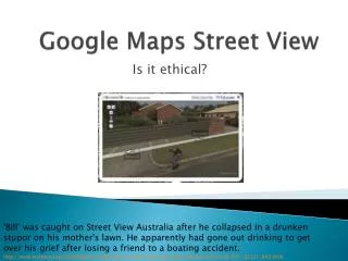
Street View http://StreetViewGallery.corank.com/tech/framed/one-brief-moment-of-sunshine
THE END Go explore the world with Google!