Download
1 / 1
10 likes | 181 Views
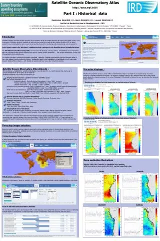
Satellite Oceanic Observatory Atlas http://aoos.mpl.ird.fr / Part I : Historical data . Dominique DAGORNE (1) - Hervé DEMARCQ (2) - Laurent DRAPEAU (2) Institut de Recherche pour le Développement – IRD

E N D
Satellite Oceanic Observatory Atlas http://aoos.mpl.ird.fr/ Part I : Historical data Dominique DAGORNE (1) - Hervé DEMARCQ (2) - Laurent DRAPEAU (2) Institut de Recherche pour le Développement – IRD (1) US IMAGO-191, Instrumentation, Moyens Analytiques , Observations en géophysique et Océanographie Centre de Bretagne – BP70 29280 – Plouzané – France (2) UR ECO-UP 097 Structuration et fonctionnement des écosystèmes d'upwelling exploités : analyses comparatives pour une approche écosystémique des pêcheries Centre de Recherche Halieutique Méditerranéenne et Tropicale , 1 Avenue Jean Monnet, BP 171, 34203 Sète – France Introduction Satellites imagery provides valuable synoptic views needed to study ecosystem dynamics at regional and global scales. Long time series of satellites products, available at high temporal resolution as well as high spatial resolution (for the latest sensors) , have contributed to make remote sensing a key element for monitoring and characterizing marine ecosystem. Use of these products by “end users” communities hasn’t reached its full potential due to accessibility issues. The Satellite Oceanic Observatory Atlas was developed to structure, process, archive, and distribute via an interactive web site, valuable remote sensing historical data sets of oceanic surface parameters : Sea Surface temperature, Ocean color (Chorophylle), Wind and Altimetry. The eastern boundary upwellings ecosystems (Benguela, California, Canaries and Humboldt) are main targeted areas of many IRD research teams conducted projects : comparative atlas, model validations, climatologically trend, meso-scale research (eddies, filament),etc .. , with studies at regional and local areas and long term duration. Satellite Oceanic Observatory Atlas data sets : All the criterias are available for selection, individually or combined, with no predefined priorities, leading to an optimal determination of the series to be displayed . Quicklook images or data (binary) are identified by : Geophysical parameters :(spatial resolution and time span) Sea Surface temperature (SST) : Analyzed products : Reynolds optimal interpolation (1 deg / 1982 - present), Thermal Infra-Red sensors : Pathfinder, MODIS (9 and 4km / 1985 (2002) - present) Passive micro-wave : TMI (1/4 deg / 1998 - present ) Chlorophyll (CHL) standard products (case 1) obtained from “color” processing Visible channels measurements : SeaWIFS, MODIS ( 9 and 4 km / 1998 (2002) – present) Wind modulus and direction by active Micro-Wave (radar) scaterometer techniques. ERS 1-2 (1 deg / 1992:2000) and QuickScat (½ deg / 2000 - present) Sea Level Anomaly (SLA) and Surface Height (SSH) from altimetry programs (1/3 deg from 1992). Sources sensors and/or program distribution : Reynolds, Pathfinder (AVHRR), Meteosat, Modis, Seawifs, Quickscat, Meteosat, Aviso,…. Temporal resolution : 1 day, 7 days, 8 days, 1 month, and climatology Spatial resolution : 1 km, 4km, 9km, 25km,35km,50km, 1deg… Geographical area of extraction : Currently 35 areas are being monitored at regional ( Atlantic ocean, Atlantic Tropical, Benguela, Canary, Humboldt,.. ) or local scale ( Marocco, South Benguela, Peru, Senegal, Freench West Indies, . ) The “Historical or “Delayed time” data set encompasses remote sensing products available from the beginning of accessible data, regulary updated from several providers ( NASA, NOAA, EUMETSAT, RSS,..). These products are "composite" based on large period (week, 8 days, month, climatology) and for use on long term climatic retrospective analysis. • The series displayer : • Whether for a full time series, a series within a restricted time range or multiple full or ranged series, the series visualiser is displayed allowing animations. The visualiser displays image of each selected series side by side, giving details about the selected coverage of the series (Metadata). A Download link allows the user to download the displayed image and data. • - Simultaneous display of a single parameter on various areas of interest : • - Simultaneous display of various parameters on a single areas of interest : • Three step images selection : • Access to specific remote sensing images is eased with intuitive cascading series of criteria/values selections. Lists displaying areas, parameters, satellites sources, temporal and spatial resolutions can be used independently or combined until there are no criterion left. • Interactive areas of interest selection • A global interactive map, provides the main navigation tools (zoom, pan, selection) which helps the determination of the areas of interest of end users. • Multi-criterias selection : • Choose any combination ( single or multiple) of possible criteria : area, parameter, source, spatial resolution, time range • List of matching series with GANTT diagram: • The resulting matching series are displayed with a Gantt diagram, showing the time span of each time series and allowing multiple display (comparisons) of series according to their compatibilities (temporal resolution and time span). Some application illustrations TRENDS 1985-2002 from SST « PathFinder V4 » monthly , with time series on some points for the 4 regional upwelling areas. CanaryBenguela HumboldtCalifornia