Gravity Modelling for Excess Mass & Density Contrast Estimation
Learn how to model gravity, estimate excess mass, and density contrast using Newton's law and bulk density calculations. Explore complex models and interpretation methods for gravity prospecting.

Gravity Modelling for Excess Mass & Density Contrast Estimation
E N D
Presentation Transcript
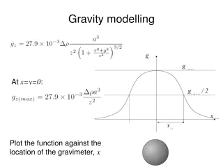
At x=y=0: Gravity modelling Plot the function against the location of the gravimeter, x
Re-arrange Newton’s law: Substitute the depth estimate (from half-width): Note: this is excess mass. To compute actual mass use: (ρ1 is the bulk density of the target, ρ2 is the bulk density of the host rock). Excess mass estimation
Density contrast estimation • density contrast, Δρcannot be determined uniquely from the data • we can put a limit on the smallest contrast that could explain the data • the largest possible sphere for a given depth extends to the surface: • here the same mass is distributed over the largest possible volume • this represents the smallest possible density contrast
Complex models • modelling may be carried out analytically (for standard shapes) • more commonly today modelling is carried out numerically • relationship between gravity profile, depth, shape, density contrast is always non-unique • concept of a “limiting depth” is usually helpful: narrow, short wavelength features cannot come from deep models • excess mass can always be uniquely determined • for gridded data, we can use
Density • Bulk density is easily defined: mass per unit volume (g/cm3), • BUT: • What is the relevant scale length? (hand sample, ore body?) • Is this in-situ (at higher temperature and pressure)? • Is the rock fluid-saturated or dry? Are we only interested in the solid matrix? • Why do we want density? • For the Bouguer correction • To explain an anomaly • Typically we are interested in density anomalies:
Densities of rocks and minerals • Density of a rock assemblage depends on • Composition • Maturity, metamorphic grade • Porosity • Fracture density • Pore fluid content, etc • Generally sedimentary rocks are less dense than igneous, metamorphic rocks (with exceptions) • Generally evaporites are high density (with exceptions) • Generally metamorphic grade increases density • Generally acidic igneous rocks are less dense than basic igneous rocks • Mineral deposits often are associated with gravity anomalies, especially metalliferous minerals
Measurement and estimation of bulk density • Direct sample measurements, for which Density = weight in air / (weight in air – weight in water) • BUT: • Difficulties in displacing air • Is porosity fluid filled? • Are in-situ conditions reached? • In-situ measurement from boreholes • Downhole gravimeter – provides an estimate of mean density between observation levels • Density logging using a radioactive source – backscattering of gamma rays (empirical correction factors, must know rock composition)
Measurement and estimation of bulk density Interpretation based method (“Nettleton’s method”)
Prairie Creek, Arkansas Gravity anomaly map P – peridotite (kimberlite pipe) B- intrusives T – tuff, sedimentary cover
Prairie Creek, Arkansas Magnetic field anomaly map P – peridotite (kimberlite pipe) B- intrusives T – tuff, sedimentary cover