Download
1 / 3
30 likes | 146 Views
National Childhood Obesity GIS Infrastructure National Level Database Inventory PHASE 1. WORKING DRAFT: JULY 15, 2010.

E N D
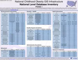
National Childhood Obesity GIS Infrastructure National Level Database Inventory PHASE 1 WORKING DRAFT: JULY 15, 2010 This is a work-in-progress list of National-level data layers prepared for inclusion in the first phase of the National Childhood Obesity GIS database. The list is organized in tables as they relate to main research categories. Each table includes layer name, data provider, mapping unit and original source format. Some layers are to be determined (TBD) based on national relevance and availability. Lists for State- and Local-level data layers are separate and can be found at HealthyKidsGIS.org Socioeconomic Environment Genetics - Health Built Environment Health Programs & Policies Administrative Boundaries Behavioral Natural Environment The purpose of the National Childhood Obesity GIS Infrastructure is to provide a comprehensive National GIS database and a web-based interactive mapping and analytical system to support the efforts of Robert Wood Johnson Foundation grantees and eventually the broader community aiming to reverse childhood obesity. The project is being conducted by the University of Florida with assistance from Practicable Legacy Strategies. Support for this project was provided by a grant from RWJF. For more information about the project or if you wish to become a pilot partner, please visit www.HealthyKidsGIS.org or contact the Project Director, Dr. Ilir Bejleri at ilir@ufl.edu. This poster is the property of the University of Florida. Any reproduction of this poster without the written consent of the University of Florida is strictly prohibited.
National Childhood Obesity GIS Infrastructure State Level Database Inventory PHASE 1 WORKING DRAFT: JULY 15, 2010 This is a work-in-progress list of State-level data layers prepared for inclusion in the first phase of the National Childhood Obesity GIS database. The list is organized in tables as they relate to main research categories. Each table includes layer name, data provider, mapping unit and original source format. Some layers are to be determined (TBD) based on state relevance and availability. Lists for National- and Local-level data layers are separate and can be found at HealthyKidsGIS.org Socioeconomic Environment Genetics - Health Built Environment Health Programs & Policies Behavioral Policies - Regulations Administrative Boundaries Natural Environment The purpose of the National Childhood Obesity GIS Infrastructure is to provide a comprehensive National GIS database and a web-based interactive mapping and analytical system to support the efforts of Robert Wood Johnson Foundation grantees and eventually the broader community aiming to reverse childhood obesity. The project is being conducted by the University of Florida with assistance from Practicable Legacy Strategies. Support for this project was provided by a grant from RWJF. For more information about the project or if you wish to become a pilot partner, please visit www.HealthyKidsGIS.org or contact the Project Director, Dr. Ilir Bejleri at ilir@ufl.edu. This poster is the property of the University of Florida. Any reproduction of this poster without the written consent of the University of Florida is strictly prohibited.
National Childhood Obesity GIS Infrastructure Local Level Database Inventory PHASE 1 WORKING DRAFT: JULY 15, 2010 This is a work-in-progress list of Local-level data layers prepared for inclusion in the first phase of the National Childhood Obesity GIS database. The list is organized in tables as they relate to main research categories. Each table includes layer name, data provider, mapping unit and original source format. Some layers are to be determined (TBD) based on local relevance and availability. Lists for National- and State-level data layers are separate and can be found at HealthyKidsGIS.org Socioeconomic Environment Genetics - Health Built Environment Behavioral Administrative Boundaries Health Programs & Policies Policies - Regulations Natural Environment The purpose of the National Childhood Obesity GIS Infrastructure is to provide a comprehensive National GIS database and a web-based interactive mapping and analytical system to support the efforts of Robert Wood Johnson Foundation grantees and eventually the broader community aiming to reverse childhood obesity. The project is being conducted by the University of Florida with assistance from Practicable Legacy Strategies. Support for this project was providedby a grant from RWJF. For more information about the project or if you wish to become a pilot partner, please visit www.HealthyKidsGIS.org or contact the Project Director, Dr. Ilir Bejleri at ilir@ufl.edu. This poster is the property of the University of Florida. Any reproduction of this poster without the written consent of the University of Florida is strictly prohibited.