Using data from Digimap in MapInfo
Using data from Digimap in MapInfo. Wednesday 3 March 2010 James Crone Vivienne Carr. Meeting content. Considerations in use of data Unzip data Data formats Data conversion Desktop sharing: Using data in MapInfo- converting data, importing data Resources Q&A.


Using data from Digimap in MapInfo
E N D
Presentation Transcript
Using data from Digimap in MapInfo Wednesday 3 March 2010 James Crone Vivienne Carr
Meeting content • Considerations in use of data • Unzip data • Data formats • Data conversion • Desktop sharing: Using data in MapInfo- converting data, importing data • Resources • Q&A
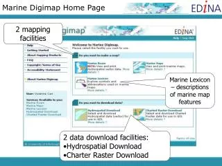
Downloading data from Digimap Collections I’ll login to one of the Data Download services EDINA servers – hold data for 4 Digimap Collections 1. Search Returns a data.zip file Download data file
Onward use of data: considerations Process the data Import data to software Analyse data / Create map Download data file • Unzip the Digimap data file • Convert the data to an appropriate format if necessary – consider formats and conversion options E.g. ArcGIS or MapInfo, CAD or Image software
Meeting content • Considerations in use of data • Unzip data • Data formats • Data conversion • Desktop sharing: Using data in MapInfo -converting data, adding data • Resources • Q&A
Unzip Digimap data.zip files Data download: 1. Data.zip 2. Unzip data.zip: Contents.txt, Conditions.txt, Data files
Unzip OS MasterMap data files 2. Unzip data.zip: 1. Contents.txt 2. Conditions.txt 3. TOID list.txt 4. How to use the data .html 5.GZip data file 1. Data.zip 3. Unzip GZip data file: GML data file
GZip files Windows standard unzip will not work – try: • Gzip, 7Zip, WinZip • May not be necessary to unzip the GZip file, depending on conversion requirements.
Meeting content • Considerations in use of data • Unzip data • Data formats • Data conversion • Desktop sharing: Using data in MapInfo -converting data, adding data • Resources • Q&A
Raster data format • Digimap raster data are supplied as TIFF files. • TFW files also supplied. • Most GIS or CAD software will accept TIFF image files, with no need for conversion. • Remember to keep the supplied TIFF files and the TFW files in the same folder! Otherwise your GIS software cannot locate the TIFF geographically.
Vector data formats GML format TIFF, SHP, NTF, MID/MIF, DXF, CSV format SHP, NTF, CSV, MID/MIF format CSV, XML, TAB format • Note that not every product is available in every format • Some data formats may be incompatible with software e.g. NTF, GML, DXF
Vector data formats • NTF (National Transfer Format) • GML (Geography Mark-up Language) • DXF (Drawing Exchange Format) • SHP (ArcView Shapefile) • MID/MIF (MapInfo export format)
Meeting content • Considerations in use of data • Unzip data • Data formats • Data conversion • Desktop sharing: Using data in MapInfo - converting data, adding data • Resources • Q&A
MID/MIF format MID/MIF is the MapInfo Interchange Format. It is one of the most commonly used geographic formats and well supported by almost every GIS product. A MID/MIF file physically consists of two files: a .mif which contains the geometry and a .mid which contains the attribute data. Both are in ascii format so they can be viewed with any text editor. The .mid is actually a comma-separated value file. The link between them is rather simple: the first line in the .mid file contains the attributes for the first geometry object in the .mif file. Source: http://www.fmepedia.com/index.php/MapInfo_MIF/MID February 2010
MID/MIF format • Code Point Polygons, downloaded from Digimap’s Ordnance Survey Collection, in MID/MIF format. • On Windows systems, the .mid file is often recognized as a midi (music) file and doubleclicking on it usually opens some application like SoundRecorder or WinAmp.
TAB format • MapInfo works with TAB (table) files; it is MapInfo’s native format. • MID/MIF files are imported to MapInfo as TAB format. Necessary to name and specify a location for the new TAB file, when importing MID/MIF. • Several component files are required to view a data set in MapInfo.
TAB component files • .DAT (The file which stores the attribute data. This usually a dBase III DBF file) • .ID (Stores information linking graphic data to the database information) • .MAP (Stores the graphic and geographic information needed to display a map on the users screen) • .IND (Optional index files for tabular data. This is present if any fields are indexed) • .TAB (The ASCII file which is the link between all other files and holds information about the type of data file)
NTF data • Convert to MID/MIF format, using NTF2MIF
NTF2MIF http://www.bodley.ox.ac.uk/users/nnj/translat.htm
GML (MasterMap) data 2 options: • Convert to MIF/MID format, using OSM2MIF convertor • Convert to TAB format using InterpOse Note: Necessary to unzip the GZip file for the OSM2MIF conversion! This step not required for InterpOse.
OSM2MIF http://www.bodley.ox.ac.uk/users/nnj/translat.htm
InterpOse • InterpOse Digimap edition - free download for GML data: http://www.dottedeyes.co.uk/spatial_data_loading/interpose/digimap.php
Meeting content • Considerations in use of data • Unzip data • Data formats • Data conversion • Desktop sharing: Using data in MapInfo - converting data, adding data • Resources • Q&A
Meeting content • Considerations in use of data • Unzip data • Data formats • Data conversion • Desktop sharing: Using data in MapInfo - converting data, adding data • Resources • Q&A
Resources EDINA Training guides: http://edina.ac.uk/digimap/support/training/
Resources • Ordnance Survey website: • General product information: http://www.ordnancesurvey.co.uk/oswebsite/products/ • Guidance on software for use with OS MasterMap: http://www.ordnancesurvey.co.uk/oswebsite/products/osmastermap/information/technical/software.html
Meeting content • Considerations in use of data • Unzip data • Data formats • Data conversion • Desktop sharing: Using data in MapInfo: converting data, adding data • Resources • Q&A