Download
1 / 51
510 likes | 690 Views
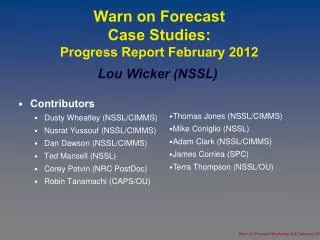
Warn on Forecast Case Studies: Progress Report February 2012. Lou Wicker (NSSL). Contributors Dusty Wheatley (NSSL/CIMMS) Nusrat Yussouf (NSSL/CIMMS) Dan Dawson (NSSL/CIMMS) Ted Mansell (NSSL) Corey Potvin (NRC PostDoc) Robin Tanamachi (CAPS/OU). Thomas Jones (NSSL/CIMMS)

E N D
Warn on Forecast Case Studies:Progress Report February 2012 Lou Wicker (NSSL) • Contributors • Dusty Wheatley (NSSL/CIMMS) • Nusrat Yussouf (NSSL/CIMMS) • Dan Dawson (NSSL/CIMMS) • Ted Mansell (NSSL) • Corey Potvin (NRC PostDoc) • Robin Tanamachi (CAPS/OU) • Thomas Jones (NSSL/CIMMS) • Mike Coniglio (NSSL) • Adam Clark (NSSL/CIMMS) • James Corriea (SPC) • Terra Thompson (NSSL/OU) Warn on Forecast Workshop 8-9 February 2012
PurposeTo test storm-scale NWP in a variety of severe weather situations • Two basic classes of events • isolated cells • mesoscale convective systems • Basic questions to be answered: • core sets of observations needed • accuracy needed of background analysis for convective scale forecasts • analysis versus prediction • predictability (0-1, 0-3, 0-6 hours?) Warn on Forecast Workshop 8-9 February 2012
Cases • Isolated Cells • Tornadic supercells • 8 May 2003 OKC F4 tornado • 4 May 2007 Greensburg KS EF5 tornado • 27 April 2011 MS/AL/TN superoutbreak • 10 May 2010 Central OK outbreak • Downburst • 14 June 2011 Norman macroburst • Mesoscale convective systems • 4 July 2004 IN/OH/KY derecho (BAMEX) • 14 June 2010 W TX tornado / flash flood (VORTEX2) Warn on Forecast Workshop 8-9 February 2012
May 8, 2003 Oklahoma City Tornadic Supercell HPC Synoptic Scale Surface Analyses at 18:00 UTC Damage Path of OKC Tornado Hu and Xue (2007) KOUN Radar Observations at 22:10 UTC Nusrat Yussouf Warn on Forecast Workshop 8-9 February 2012
8 May 2003: Multiscale experiment EnKF used at multiple scales • Mesoscale Ensemble • 45 member WRF mesoscale ensemble at 18 km horizontal grid spacing • over CONUS initialized from GFS • 3 day cycling with assimilation of routinely available observations from metar, marine, radiosondes and ACARS using DART system • Physics options used: MYJ, Thompson, Kain-Fritsch, Noah, Dudhia and RRTM • Storm-scale Ensemble • 45 member storm-scale ensemble nested down from • the 45 member mesoscale ensemble data system • 2-km horizontal grid spacing, 225 x 180 x 50 grid points • Assimilates KTLX radar radial velocity and reflectivity observations every 3-min for a one-hour period T - 3 days 8 May Nusrat Yussouf Warn on Forecast Workshop 8-9 February 2012
mesocyclone mesocyclone Reflectivity, Vorticity and Horizontal Winds at 1 km AGL Ensemble Member #9 30 min Forecast at 22:30 UTC Final Analyses at 22:00 UTC 15 min Forecast at 22:15 UTC Nusrat Yussouf Vorticity contours: 0.005 to 0.01 by 0.001 KTLX Reflectivity at 22:31 UTC KTLX Reflectivity at 22:01 UTC KTLX Reflectivity at 22:16 Warn on Forecast Workshop 8-9 February 2012
Probability of Vorticity During 45-min Forecast Period 22:00 – 22:45 UTC z ≥ 0.003 s-1 at 1 km z ≥ 0.005 s-1 at 3 km ~22:38 ~22:38 ~22:38 Observed damage track and times Observed damage track and times ~22:06 ~22:06 Probability (%) Nusrat Yussouf Warn on Forecast Workshop 8-9 February 2012
Greensburg KS (2007) • EnKF analysis and prediction of the significant tornadic storm on 5 May 2007 storm near Greensburg, KS • Single radar retrieval using DDC Vr & dBz • Homogeneous initial environment • Examined sensitivity to low-level wind profile and (to a lesser extent) microphysics Dan Dawson Warn on Forecast Workshop 8-9 February 2012
0130 0200 0230 Probabilistic Vorticity Forecast (All 9 experiments) Background VAD Profile (UTC) Used 60 min forecasts 45 min forecasts Dan Dawson Warn on Forecast Workshop 8-9 February 2012
Experiment 1: 1900-2000 UTC initialization Radar DA Experiment 2: 2100-2200 UTC initialization Radar DA KHTX KGWX KBMX KDGX observed tornado tracks 27 April 2011 Tornado Outbreak:EnKF Radar DA and Ensemble Forecasts 45-member WRF-ARW ensembles (Δx=3 km) initialized from Rapid- Refresh model (Δx=13 km) at two times (1900 and 2100 UTC) Data from 4 radars assimilated every 3 min for 1 h KBMX, KDGX, KGWX, KHTX additive noise only source of ensemble spread Ensemble forecasts produced after radar DA 19Z 20Z 21Z 22Z 23Z ensemble forecast 21Z 22Z 23Z ensemble forecast David Dowell Warn on Forecast Workshop 8-9 February 2012
Two Ensemble Forecasts:initialized at different times, valid at same time Ensemble-Based Probabilities of Rotating Updrafts 2200-2300 UTC 27 April 2011 northern swath of high probability changed relatively little southern swath moved significantly based on recent radar data and/or RR mesoscale analysis 2-3 h forecast initialized at 2000 UTC 0-1 h forecast initialized at 2200 UTC David Dowell Warn on Forecast Workshop 8-9 February 2012
0-1 h ForecastEnsemble Member 1 observed tornado tracks model maintains long-lived storms initialized in Tuscaloosa County and Cullman/Blount County observed composite reflectivity NSSL/Q2 Mosaic3D 2200 UTC 2-5 km AGL Max Updraft Helicity 2200-2300 UTC David Dowell Warn on Forecast Workshop 8-9 February 2012
dBZ 0030 UTC June 14 Macroburst http://www.srh.noaa.gov/oun/?n=events-20110614 • Measured wind gusts > 36 m/s (130 km/hr) • Wind-driven golf ball or larger hail • 33,000 residents without power for over a day • Residential damage took > 4 months to repair Downburst Lou Wicker Warn on Forecast Workshop 8-9 February 2012
CAPE~200 Weak elevated convection ongoing for hours Cold Front 2245 Vis deep convection initiates ~2330 UTC Mesoscale Environment CAPE~3200 LCL~730 mb CAPE~2200 LCL~730 mb Moderate shear Lou Wicker Warn on Forecast Workshop 8-9 February 2012
Model Analysis vs Radar Obs at 0010 UTC KOUN Location 35 min of radar DA 8 radar volumes Lou Wicker Warn on Forecast Workshop 8-9 February 2012
Ensemble Forecast Output of Severe Wind Probability Vectors Wind speed > 20 m/s Color at least 33% of members have 25 m/s < wind speed < 40 m/s 20 minute Ensemble Forecasts of Svr Wind (0030 UTC) 3DVAR SFC WIND FIELD Verification Wind Plot Vectors: Wind speed > 10 m/s Color: 20 m/s < wind speed < 40 m/s Ensemble Prediction for SVR SFC WINDS Lou Wicker Warn on Forecast Workshop 8-9 February 2012
The 4-5 July 2003 MCS event - Observed during BAMEX - Produced 100+ wind reports across Indiana and Ohio - Contributed to record flooding across north-central Indiana - Not captured in NWP models of the day (including the WRF model) 2130 UTC 2300 UTC 0030 UTC 0200 UTC Dusty Wheatley Warn on Forecast Workshop 8-9 February 2012
Sensitivity to previous convection Depicts movement of two earlier systems 4 July 2003 MCS Gravity wave Outflow boundary From Davis et al. 2005 Satellite imagery from 4 July 2003 Dusty Wheatley Warn on Forecast Workshop 8-9 February 2012
EnKF analyses at 2300 UTC Surface data DA needed on storm-scale grid OBS Better cold pool analysis Radar + Sfc DA Radar DA only • 1.5-km AGL simulated reflectivity • 2-m temperature (deg C) • 10-m winds (full barb = 10 ms-1) Sub-hourly surface data Dusty Wheatley Warn on Forecast Workshop 8-9 February 2012
Simulated reflectivity from sample members at 0030 UTC 5 July Dusty Wheatley Warn on Forecast Workshop 8-9 February 2012
EnKF analyses of 2-m temperature 2300 UTC 4 Jul 30 min fcst 60 min fcst 90 min fcst Radar DA only Inc. sub-hourly surface DA With the assimilation of sub-hourly surface data, the mesoscale cold pool is better developed at the last analysis time (2300 UTC) and subsequent forecast times. Dusty Wheatley Warn on Forecast Workshop 8-9 February 2012
June 14, 2010 west-TX VORTEX2 event 1. Severe weather: x LBB • HP supercell with weakly tornadic mesocyclone along gust front/pre-existing boundary intersection • Severe wind gusts (34 – 37 m s-1 measured by VORTEX2) and strong cold pool (ΔT 15 - 18 K) Focus area 1937 UTC 6-h QPEs ending 00Z 15 June 2010 2. Flash flood: NSSL Q2 Stage IV x LBB x LBB 6”+ max 3”+ max 100 km 100 km Mike Coniglio Warn on Forecast Workshop 8-9 February 2012
Initial mesoscale assimilation tests: Final analysis valid 18 UTC RUC analysis EnKF mean EnKF mean reduces analysis errors vs. RUC 2-m T RMSD = 1.90 ME = 0.19 RMSD = 2.35 ME = 0.47 But moist bias remains (MYJ PBL scheme) 2-m Td RMSD = 2.10 ME = 0.54 RMSD = 1.70 ME = 0.51 Mike Coniglio Warn on Forecast Workshop 8-9 February 2012
1 Hour Radar Assimilation Experiments: Final analysis valid 19Z Mike Coniglio Warn on Forecast Workshop 8-9 February 2012
Total 3-h accumulated precipitation 19-22 UTCNMQ QPE (color shading) and ensemble raw probabilities > 10 mm (contours) 1-radar 4-radars Little to no backbuilding, convection moves too fast to east More backbuilding, slower eastward movement, but still too far east overall Accumulation too low in most runs Mike Coniglio Warn on Forecast Workshop 8-9 February 2012
GOES Cloud Property Assimilation using WRF-DART • Initial Implementation: convert NASA Langley retrieval algorithm cloud properties into proxy WRF state variables • Use Cloud Top Pressure (CTP) and Cloud Base Pressure (CBP) to determine 3-D location of cloud • Create QCLOUD, QICE, QGRAUPEL, QRAIN, Relative Humidity • Proxy columns on GOES horizontal grid with ~50 hPA vertical resolution Thomas Jones Warn on Forecast Workshop 8-9 February 2012
GOES Visible & CTP/CBP2045 UTC Cirrus Outflow • Convection initiating ahead of dryline in OK • Low-level clouds present in eastern OK Developing Convection Low-level clouds CTP ~200 hPa CTP ~800 hPa Thomas Jones Warn on Forecast Workshop 8-9 February 2012
WRF-DART Characteristics 15 km Domain • WRF-DART • ARW, version 3.2.1 • EnKF assimilation using 36 members • Use 15 km CONUS and 3 km one-way nested grid domains • Mesoscale assimilation window from 1200 UTC – 2100 UTC 10 May • 1 hour intervals • Nested grid assimilation 1800 – 2100 UTC • 15 minute intervals • Create 2 runs: • One assimilating derived cloud and humidity variables (CLD) • One with variables set to evaluate-mode only (NOCLD) 3 km Domain Thomas Jones Warn on Forecast Workshop 8-9 February 2012
QCLOUD Differences2045 UTC • Large areas of differences at 900 and 850 hPa • Magnitude ~ 0.1 g kg-1 • Greatest differences near developing cumulus and in low-level clouds fields further east • Interesting wave-like pattern in QCLOUD differences at 850 hPa RED = CLD Greater BLUE – NOCLD Greater • Differences at 700 hPa and above have limited coverage • Only significant differences occur along dryline • Also see differences in model IWP (black shading) • Hard to ascertain physical significance of these differences Thomas Jones Warn on Forecast Workshop 8-9 February 2012
1 hour reflectivity forecast • Probability of simulated reflectivity > 25 dBZ changes between NOCLD and CLD ensembles • Neither shows much skill relative to the other Thomas Jones Warn on Forecast Workshop 8-9 February 2012
Summary • Two supercell cases: SS-NWP can predict the track of the strongest rotation with some accuracy in 0-1 hour time frame. • Using tornado proxy for track - less skill with genesis/decay • Microphysical parameterization strongly impacts the forecast at these scales. • Need to test cases from environments with more marginal tornado parameters • Initial macroburst forecast is promising Warn on Forecast Workshop 8-9 February 2012
Summary • Mesoscale convective systems • accurate depiction of mesoscale environment critical • Multi-radar improved QPF predictions • Satellite case • Takes 2 hours of assimilation of cloud properties to start making a difference • GOES-R should reduce this time by providing 5 – 10 minute resolution data. • Results likely very sensitive to microphysics Warn on Forecast Workshop 8-9 February 2012
Take Aways.. • Prediction of isolated severe convection shows promise • MCS’s appears to have more challenges • Everything matters? • success with isolated cells: getting the (enough) details right over a small area? • MCS problem may require getting the details right over a much larger area... • Its the boundary layer.... • much of forecast error can be traced (we think) to errors in boundary layer structure of humidity and temperature • all phases of convective evolution (initiation, intensification, decay) are impacted by these errors (even tornadogenesis?) Warn on Forecast Workshop 8-9 February 2012
Thanks Questions? Warn on Forecast Workshop 8-9 February 2012
Verification Warn on Forecast Workshop 8-9 February 2012
Establishing metrics of success Spatial location CA Timing Verification with Tornado reports Obs cell density axes (30 min) # members # storms -# storms verified UH Model proxy Tornado Members shifted and focused more north than observed with minimal members co-located with TOR
Which DA verifies best? Being storm specific next hour Percent severePercent model severe 25 50 75 100% C A B Storm Severe Storm • No threat now • Tornado threat in 30 min • Decaying threat (storm ongoing) • Explicit forecast of which storms will be severe and which won’t
Microphysical ParameterizationDevelopment(T. Mansell, D. Dawson, Y. Jung, M. Xue) • Development of 3-moment microphysical scheme suitable for deep convection • Testing of 3-moment scheme within EnKF framework • Verification of microphysical parameterizations • using dual-polarization radar data • forward operator from Y. Jung and M. Xue • collaboration with CAPS Warn on Forecast Workshop 8-9 February 2012
Microphysical Sensitivity Observations 8 May 2003 22:10 (tornadogenesis) 22 minute ensemble mean forecast with multi-moment microphysics valid 22:10 22 minute ensemble mean forecast with single-moment microphysics valid 22:10 Warn on Forecast Workshop 8-9 February 2012
Microphysical SensitivityGreensburg KS ForecastsSingle vs. Two Moment Microphysics Single Two Warn on Forecast Workshop 8-9 February 2012
GOES Cloud Property Assimilation • GOAL: Provide model analysis information on the location and vertical distribution of clouds • Need high spatial and temporal resolution data • 1 km, 30 minute cloud property retrievals available from GOES-13 data • Uses NASA Langley retrieval algorithm • Products include: • Cloud top pressure (CTP) • Cloud base pressure (CBP) • Cloud liquid water path (CLWP) • Cloud ice water path (CIWP) • Cloud phase • These variables are not suitable for direct assimilation into WRF-DART • Must convert to something it understands Warn on Forecast Workshop 8-9 February 2012
Observation Diagnostics • QCLOUD • No difference in bias or RMSE between 18-2000 UTC • Some reduction in bias and RMSE after 2000 UTC • Reduction increases with time • Max reduction ~0.05 g kg-1 • RH • Differences small at all times • Posterior bias and RMSE at 2100 are smaller by ~0.5% • Sample size • ~800 Q* data points assimilated at each time interval • Total possible: ~1300 • ~300 for RH • Saw-tooth pattern a result lower sample size at interpolated times (00, 30) Warn on Forecast Workshop 8-9 February 2012
QCloud and RH Data at 2045 UTC • Where low clouds exist, RH=100% assimilated • Above 850 hPa, few clouds resulting in QCLOUD = 0 being assimilated 1800 – 2100 UTC Sample size QCloud data RH data 50 Thomas Jones Warn on Forecast Workshop 8-9 February 2012
Cross Sections QCLOUD IWP • Small differences in location of QCLOUD peaks • 5-10 km offset • Magnitude of IWP also differs Warn on Forecast Workshop 8-9 February 2012
Issues/Challenges to Explore Low-level moist bias in the warm sector- will multiple PBL/land-surface schemes help? Only using MYJ currently. TTU SND 1732 • Case-specific challenges/questions: • Event has multiple convective modes and a strong cold pool. Can Δ=3 km simulations produce a strong cold pool while still restraining its eastward propagation, as was observed? 2011 CAPS 4-km runs Currently trying experiment with MYNN Bnd LYR scheme Environment from MYNN (MYJ) run from 2011 CAPS ensemble one of the best (worst) fits to observed soundings (see poster for more info). EnKF meanT, Td 1800 Mike Coniglio Warn on Forecast Workshop 8-9 February 2012
Ensemble Forecast Output of Severe Wind Probability Vectors Wind speed > 20 m/s Color at least 33% of members have 25 m/s < wind speed < 40 m/s 10 minute Ensemble Forecasts of Svr Wind (0020 UTC) 3DVAR SFC WIND FIELD Verification Wind Plot Vectors: Wind speed > 10 m/s Color: 20 m/s < wind speed < 40 m/s Ensemble Prediction for SVR SFC WINDS Lou Wicker Warn on Forecast Workshop 8-9 February 2012
Ensemble Forecast Output of Severe Wind Probability Vectors Wind speed > 20 m/s Color at least 33% of members have 25 m/s < wind speed < 40 m/s 15 minute Ensemble Forecasts of Svr Wind (0025 UTC) 3DVAR SFC WIND FIELD Verification Wind Plot Vectors: Wind speed > 10 m/s Color: 20 m/s < wind speed < 40 m/s Ensemble Prediction for SVR SFC WINDS Lou Wicker Warn on Forecast Workshop 8-9 February 2012