Download
1 / 58
1.11k likes | 2.53k Views
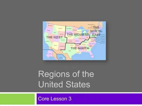
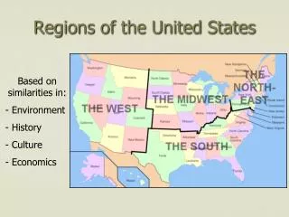
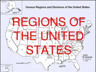
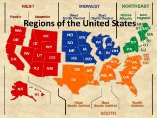
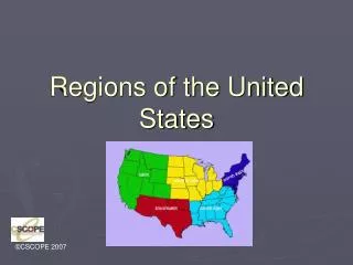
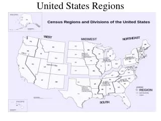
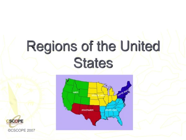
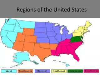
Regions of the United States. Class Outline. Northeast South Midwest &Great Plains Rocky Mountains/Basin States, including Southwest Pacific Coast . Topics discussed for each Region. Physical Geography Historical Geography Population Geography Economic Geography Cultural Geography.

E N D
Class Outline • Northeast • South • Midwest &Great Plains • Rocky Mountains/Basin States, including Southwest • Pacific Coast
Topics discussed for each Region • Physical Geography • Historical Geography • Population Geography • Economic Geography • Cultural Geography
The Northeast • Northeast • Maine, New Hampshire, Vermont, Massachusetts, Connecticut, Rhode Island, New York, New Jersey, Pennsylvania, Delaware, Maryland, and the District of Columbia • The Northeast can be subdivided into two smaller regions: 1) New England, and 2) Mid-Atlantic States.
Physical Geography of Northeast • Northern Appalachian mountains run through most of the northeastern states, causing little farmland, except in valley areas. • Coastal plain is narrow, with an area between the mountains and coast called the fall line. • Deep bays exist, allowing for port towns. • Jagged, rocky coastline in northern areas.
Climate and Vegetation of Northeast: Humid Continental • No Dry Season- this area receives precipitation throughout the year. • Cold, snowy winters and hot summers. • Moderate growing season that decreases as you go north. • Vegetation is mixed forests with deciduous and coniferous trees. World Geography, Unit 3, Lesson 1
Historical Geography of the Northeast • The Northeast has the longest history of European settlement . • Historically, the Northeast has been the gateway to immigrants. • Established itself as the financial and manufacturing hub early in the industrial revolution.
Population Geography of the Northeast • Population is concentrated in the Megalopolis that runs from Boston to Washington (AKA Boswash). • This is the most densely populated region in the United States.
Boston – Washington: Washington/Baltimore – Philadelphia = 1.5 hrs Philadelphia-New York = 1.25 hrs New York – Boston = 3.5 hrs *estimated driving times, faster if by train BB
Economic Geography of the Northeast • The New England states have a long history of maritime industry, although forestry exists inland with little farming. • The Mid-Atlantic states dominate the financial sector of the U.S., advertising, manufacturing. • This region is the home to most major corporations in the United States.
Land Use in the Northeast • Dairy Farming (think Vermont…) • Farming • Timber • Maritime Activity • Some mining • Note: As you go north, the growing season shortens, which limits farming. In part of the Northeast, timber is a primary economic activity.
Economic Geography • Northeast is the heart of the manufacturing core, but lately has been termed the RUST BELT. This extends into the Midwest. • Why do you think it’s called the Rust belt? Where have industries relocated? Why?
Cultural Geography of Northeast: Mid-Atlantic • South of New England, the Mid-Atlantic states enjoy warmer weather and a longer growing season. • The economy has more farming activity and has less maritime activity, although major shipping waterways are present. • Major cities are located on these major waterways: New York is on the Hudson R., Philly is on the Delaware, and Baltimore is located on Chesapeake Bay.
More on the Mid-Atlantic States • This area is a transition zone between the Northeast (New England in particular) and the South, especially the states of Virginia and W. Virginia. • Heritage is also centered on colonial times and the American Revolution, although less so than in New England. • Home to Washington D.C., the political center of the U.S.
The South • States included: North Carolina, South Carolina, Florida, Georgia, Alabama, Mississippi, Tennessee, Arkansas, and Louisiana • Transition States: Virginia, W. Virginia, Kentucky, Missouri, Oklahoma, and Texas
Variations on the South • Deep South- consists of the six founding members of the Confederacy: S. Carolina, Mississippi, Georgia, Alabama, Florida, and Louisiana • Appalachia Region: Virginia, W. Virginia, Tennessee, Kentucky, and parts of N. Carolina, Georgia and Alabama • Cajun South: Louisiana and East Texas • Gulf Coast States: Florida, Alabama, Mississippi, Louisiana, Texas
Notes about Transition States • Southern Louisiana is influenced by French, Caribbean, and Latin American history. • Texas is divided into the South, Great Plains and Southwest regions. • Oklahoma is also included in the Great Plains region for two reasons: Climate and “Indian territory”.
Physical Geography of the South • Dominated by a wide coastal plain, and meandering river basins • What is the most prominent river basin in this region? • Where is its delta?
Climate and Vegetation of the South • Humid subtropical, with hot, humid summers and long growing season. Winters are mild, seldom with snow. There is no dry season. • Vegetation: Mixed forests. The South is known for plants such as live oaks, magnolia trees, flowering dogwoods.
Historical Geography of the South • The South was settled as an agricultural region, with slavery and cash crops as its driving force. The climate and physical landscape were well suited for an agricultural society. • Historically, the South was settled by many different cultures, although the Anglo Protestant plantation farmers were the dominant group. • Other cultures included: Spanish, Caribbean, Creole, Cajun
Population Geography of the South • The South’s population is evenly distributed, except increase in density around urban centers. • Examples: Atlanta, New Orleans, Mobile, Miami
Economic Geography of the South • Historically based on agriculture, with tobacco and cotton being the first cash crops. • Although agriculture has dominated the economy, service industry, manufacturing, and high tech industries are also located in the South. • Fishing is a common activity in Gulf Coast States. • Tourism along the Gulf Coast, especially Florida. • Oil Industry is located in the Gulf and in cities like Houston and Beaumont, close to continental shelf drilling.
Cultural Geography of the South • Deep South • Appalachians • Gulf Coast region • Florida • Cajun South and East Texas
Music of the South • The South is the origin all these types of music: • Rhythm and Blues • Jazz • Bluegrass • Appalachian Folk Music • Gospel • Country music • Zydeco • Rock n Roll (Elvis/Memphis)
Midwest • Included States: Michigan, Ohio, Indiana, Illinois, Wisconsin, Minnesota, and Iowa • Transition States: Pennsylvania, Missouri
Physical Geography of Midwest Flat landscape, with river basins. Distinctive Great Lakes, which provide for shipping.
Climate of the Midwest: Humid Continental • No Dry Season- this area receives precipitation throughout the year. • Cold, snowy winters and hot summers. • Moderate growing season that decreases as you go north. • Vegetation is mixed forests with deciduous and coniferous trees.
Historical Geography of the Midwest • The Mid-west was considered the “Western Frontier” early in American History, hence the name. • Historically known as the breadbasket of the U.S., as this is also an agricultural region that produces a lot of grain as well as other crops. • Also known as a manufacturing, blue-collar hub of the U.S.
The Midwest as a Cultural Crossroads • Immigrant groups: • Scots Presbyterians settled in Pennsylvania. • Dutch Amish and Quakers settled in Ohio and Indiana. • German Lutherans settled in Ohio, Wisconsin, Illinois and Eastern Missouri. • Swedes and Norwegians settled in Wisconsin and Minnesota. • Polish, Hungarians, German Catholics, and Jews settled in Midwestern cities.
Population • Large cities include Chicago and Detroit • The region is evenly distributed. • Population is dense along the Great Lakes.
Economic Geography • Dairy Farming in Wisconsin and Minnesota • Fruit Orchards in Michigan • Corn in Indiana, Illinois, and Iowa • Manufacturing in urban cities along Great Lakes, like Pittsburgh, Cleveland, Detroit and Chicago (Steel Towns).
Breadbasket of the USA • Corn is most notably grown, but soybeans, wheat, and fruits orchards are also commonly found throughout the Midwest. • Dairy products are famous in which state in the Midwest?
Cultural Geography • Home to various immigrant groups, which causes ethnic, racial, and religious diversity in the cities. • Cuisine reflects the cultural and physical diversity: Chicago style pizza, Polish bakeries, Wisconsin cheese, and Michigan’s apple cider mills and fruit orchards.
Great Plains Region • Strip of States through the center of the country • Includes: Kansas, Nebraska, South Dakota, and North Dakota • Transition States: Oklahoma, Panhandle of Texas, Eastern Colorado, Wyoming and Montana
Physical Geography of the Great Plains • The Great Plains are also called the High Plains, as the elevation increases gradually as you go west. • Generally flat with some rolling hills • Major River Basins: Red R., Arkansas River, Platte River, and the Missouri River
Climate of the Great Plains • Generally the Great Plains is Steppe climate (Grasslands). Some of the eastern areas have Humid Continental climate. • This area receives little rainfall (less than 18 in. a year on average). • Cold winters, especially in the northern areas
Historical Geography of the Great Plains • Before Americans settled the frontier, the Great Plains was home to several indigenous cultures, most notably the Sioux, the Cheyenne, and the Arapaho. • During the 19th century, the Great Plains became the staging point of war between the native people and the American settlers.
More on Historical Geography • The Great Plains were also used for cattle grazing and cattle drives. • Many of the cities in this area were founded as railroad hubs for cattle.
Homestead Act of 1862 • This act provided each settler with 160 acres of land, as long as he cultivated the land. • This caused a rush of settlers to the Great Plains region in the 1800s. • Ironically, the Great Plains has lost a third of its population since 1920. Kansas has 6,000 ghost towns.
Population of the Great Plains Two words: Rural and declining Why do you think the population is declining in these areas?
Economic Activity • Wheat – another important crop (the Dakotas) • spring wheat major crop in the north • winter wheat (Kansas) • Associated with wheat are sorghums, barley, and livestock production • Cattle are also a primary economic activity in the Great Plains.
Ogallala (High Plains) Aquifer • Because there is little rainfall, farmers use the aquifers to irrigate crops. The Ogallala is one of the largest in the U.S., but it is being depleted at a high rate. • The Aquifer runs from the Texas Panhandle to Nebraska. Almost the entire state of Nebraska lies on top of the Aquifer.
Mountain and Basin States • States included: New Mexico, Colorado, Wyoming, Montana, Idaho, Utah, Nevada, Arizona • Transitions: Colorado, Wyoming and Montana are also Great Plains States. Texas • Southwest: Texas, New Mexico, Arizona, Southern Utah/Nevada
Physical Geography • Characterized by the steep and jagged Rocky Mountain Range, foothills of the Rockies, High Deserts and Intermountain Basins • Diverse physical region, including landforms and climates
Climates • Highland climate is found throughout the Rockies. • Desert and Steppe are found in the Southwest and Basin area. • In general, the area is arid. Farming is done with irrigation.
Historical Geography • Mining towns • Outlaws (Wild West) • Cattle/Sheep Grazing • Reservation Lands • Las Vegas and Reno- Gambling towns • National Park Service
Population Geography • Not densely populated • Major urban centers include: Denver, Salt Lake City, Phoenix
Economic Activity • Grazing • Mining • Tourism • Lumber