Download
1 / 25
250 likes | 361 Views
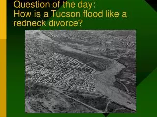
Question of the day: How is a Tucson flood like a redneck divorce?. Rainfall in southern Arizona A Case of Famine and Feast. Digital Elevation Map. Colorado Plateau. General airflow from Pacific. Mogollon Rim. Basin and Range. You are here. Annual Precipitation.

E N D
Question of the day: How is a Tucson flood like a redneck divorce?
Digital Elevation Map ColoradoPlateau General airflow from Pacific Mogollon Rim Basin and Range You are here.
Annual Precipitation Sky Islands of SE Arizona
Main channel is normal course of river. Floodplain is area covered during flood. Over geologic time, river meanders over floodplain. Anatomy of River Valley
Flow Gauge Records, Santa Cruz River 1983 1914 1965 1977 1983 flow = 53,000 cfs (Equivalent to 16 backyard swimming pools per second!) 25% above previous 100-year flood estimates. More frequent record flows post 1960
Bank erosion along the outside of a meander bend Rillito at First Avenue, Oct. 1983
Active river channel moves by bank erosion. This is principle flood hazard in Tucson. Rillito Creek at First Avenue, Tucson, 1983 October, 1983 flood: 8 deaths, ~1000 injuries; $250 million damage.
Increased frequency of record Santa Cruz flows since 1960.A. Climatic effect? Global warming? Enhanced El Nino?B. Urbanization? Urbanized desert increases runoff by four times compared to undeveloped desert.
Effects of Urbanization on Stream Flow Before After Urbanization decreases lag time and increases maximum flow.
Flood Forecasting 100-year flood projections depend on models of climate and hydrology.
Flood Control MeasuresA. StructuralDams Channelization Diversion channelsB. NonstructuralZoning and land-use restrictions Land acquisition programs Flood forecasting Public education Pima County
Soil cementing, Rillito @ Campbell Confine the flow. Move the water out of Tucson ASAP.
A: Sooner or later, someone’s going to loose a trailer. Q: How is a Tucson flood like a redneck divorce?