Download

1 / 21
210 likes | 229 Views
Explore the capabilities of dual-polarimetric radar in research and operations, focusing on its applications in the Tennessee Valley. Discover basic variables and innovative research methods for precipitation science. Learn how dual-pol radar provides unique insights into precipitation processes and enhances weather data collection. Benefit from improved hydrometeor identification and calibration techniques for better forecasting accuracy. Take advantage of advanced technology for severe weather monitoring and satellite data analysis.

E N D
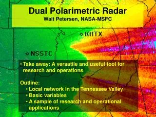
Take away: A versatile and useful tool for research and operations • Outline: • Local network in the Tennessee Valley • Basic variables • A sample of research and operational applications Dual Polarimetric Radar Walt Petersen, NASA-MSFC
Why does NASA care about ground-based dual-polarimetric radar? NASA Precipitation Science • Dual-pol radar provides the means to remotely sense precipitation processes over volumes of atmosphere not practically accessible by other means. • Advancement of physically-based satellite retrieval algorithm development.
Basic Polarimetric Radar Variables Zh, kh Variables…….. • Reflectivity factor Z at horizontal (Zh) or vertical (Zv) polarization [Conventional radar measure] • - Measure of drop size andconcentration; • Most sensitive to drop SIZE (D6) • 2. Differential reflectivity ZDR (Zh/Zv) • - Measure of median drop diameter→SIZE/SHAPE • - Useful for rain / hail / snow discrimination→SIZE/SHAPE • 3. Propagationdifferential phase KDPS(kh – kv) • - Measure of water content and drop size→NUMBER/SHAPE • - Immune to radar calibration, attenuation, partial beam blockage • 4. Correlation coefficient ρhv • - Indicator of mixed precipitation → SHAPE/PHASE/CANTING (Depolarization) • - Useful for identifying non-meteorological scatterers too! We need the measurement in H and V directions! Zv, kv • Advantages: Better description of various particle types/shapes in a given volume • Determine size distribution- more accurate rain rates (improved QPE) • Hydrometeor ID and non-meteorological scatterers (clutter!) • Consistent calibration Walter A. Petersen NASA MSFC VP-61
UAH/NSSTC THOR Center and Hazardous Weather Testbed MAX ? KHTX MIPS/NSSTC 68 km ARMOR RSA 75 KGWX ARMOR DD lobe 1 km Res. 1.5 km Res. LMA 100-500 m MAX MIPS Profiler LMA Antenna NEXRAD KBMX Some Tools: N. Alabama Dual-Pol Radars and Supporting Infrastructure • Instruments/Infrastructure • Radars: • C and X-band dual-polarimetric • VHF Lightning mapping array • Mobile Integrated Profiling System (MIPS) • Surface met./Sounding • Network of Disdrometers, Rain gauges • Model/Forecast R&D (NASA SPoRT) • Science/Application: • Operational: Severe weather, QPE, lightning, WRF model; NOAA-HWT, NWS-COMET, TVA • Basic/Applied Research: QPE, Cloud Physics and kinematics, cloud electrification, boundary Layer and convective initiation • Satellite: NASA satellite precipitation retrieval algorithms, NOAA-GLM risk reduction • Technology Transfer : • UAH: Graduate student education • NWS-Huntsville: Ops/Training • TVA: Radar applications • WHNT-TV (other markets): Dual-pol applications, public awareness RESEARCH + TECHNOLOGY TRANSFER Academic, Govt./Public, Private Sectors
Jumping right in with both feet………….. Microphysics: 25 July 2007 Heavy rain/hail mix,large drops Demonstrating the Microphysical sequence in a T-storm: Antiquity of application. rhv Z ZDR Vert. Develop/Mixed Phase Ext.Mixed phase Glaciating Glaciated
Using DP Variables for Thunderstorm /Lightning Remote Sensing Phase shifts due to vertically-aligned ice crystals E-field increase Vertical alignment Lightning E-field decrease Crystal relaxation • Project: NASA MSFC Support of launch operations at KSC/CCAFS • Question: Can we exploit the dual-pol characteristics for lightning initiation and cessation nowcasting/ Proprietary content: Walter A. Petersen NASA MSFC VP-61
Cool season applications: Melting level asymmetry………. Melting level ID is a big problem in traditional radar QPE Veering in a pre-frontal zone rhv VR Note asymmetries in ZDR and RHOHV “bright bands” ZDR Polarimetric variables, in particular RHOHV, are much more sensitive to presence of mixed phase Proprietary content: Walter A. Petersen NASA MSFC VP-61
ARMOR 1/29/2010: Cold Season Mixed Phase w/Complex FL height • Problem: • Temperatures around or just above freezing….. • Where is it liquid, freezing and frozen? • Z has only limited information • In this case, RHOHV adds considerable information • We could interpret individual variables (takes time/practice) • or..........?
Combine Pol variables into “easy to digest” information: Hydrometeor ID Originally (90’s) we used simple tables…. But boundaries between categories in nature are soft……move to “fuzzification” Vivekanandan et al. (1999, BAMS) Liu and Chandrasekar, 2001 Vivekanandan et al., 1999
ARMOR: 1/29/10 Cold Season Mixed Phase: Now add HID- easier to interpret
First IC 1655 Dual-Pol HID: N. AL Downburst Case and Lightning Ze • First precip echo 1639 UTC • Low level rain w/ strong development at T< 0oC • Mixed phase development 1648-1652 UTC • First Lightning 1655 UTC • Whole mixed phase core falls by 1702 UTC, last CG lightning 1703 UTC, last IC 1705 First CG 1702
QPE: Dual-Pol Selling point- Hybrid Polarimetric Rainfall Algorithms Premise: Combined variables account for clutter, DSD variability, and phase ID
Application for TVA : ARMOR Distributed Rainfall Products (AREPS) Accumulated and Generated Every 5-minutes 1-hr Accum. 6-hr Basin Mosaic Operational Products: Image and Text Text file for 6-hour accumulation 6-hr Accum. • Also transmitted to TVA: • Basin 1-hour accumulations • Gauge-location max, min and mean Walter A. Petersen NASA MSFC VP-61
AREPS QPE Product Verification: ARMOR vs. TVA rain gauges (October 2007 – June 2008) Point Comparisons Bias = -10% (-0.99 mm) Error = 12% Critical: For operational applications a constant monitoring of calibration maintains precision and accuracy of product. Walter A. Petersen NASA MSFC VP-61
CHILL: Rainfall Accumulation Optimization Algorithm CHILL: Rainfall Accumulation NEXRAD Z-R Algorithm Colorado CSU-CHILL Radar ICE-Algorithm (R. Cifelli)
Tropical Cyclone Rita Tornadoes KDP, RHOVH used to map debris trace Size sorting and spatial separation of drops-microphysics feedbacks on dynamics? Tornado Debris (2/6/2008)
Dual Pol radar is an outstanding tool for exploring and detecting many different manifestations of weather. When implemented in network form, it will be the next leap in both research and operational applications. Having said that…………….
We should also admit that dual-pol radar is not the “pot of gold at the end of the precip remote sensing rainbow”……
It won’t completely replace our best rain gauges…………
It won’t solve all of our rainfall-related issues………….
In the end…..it will be the combination of Dual-pol radar with other observations and our ability to assimilate that ensemble of information into human and automated analysis/modeling systems that will be the key! DSD Particle types/phase Rain rate 3-D Precip structure and evolution Microphysical feedbacks to dynamics Hydrology and water budgets And more………. W. Petersen, NASA-MSFC