Traversing Techniques in Land Surveying
Learn how to establish a traverse for accurate mapping, compute coordinates, and handle errors in angular and linear measurements.


Traversing Techniques in Land Surveying
E N D
Presentation Transcript
Traversing • Definition: • A traverse is a series of consecutive lines whose lengths and directions have been measured. • Why? • The purpose of establishing a traverse is to extend the horizontal control. A survey usually begins with one given vertical control and two ( or one and direction) given in horizontal • You need more than two points to control the project, have enough known points to map any point, and set-out any object any where in a large project.
Traversing • Definition: • A traverse is a series of consecutive lines whose lengths and directions have been measured. • Why? • The purpose of establishing a traverse is to extend the horizontal control. A survey usually begins with one given vertical control and two ( or one and direction) given in horizontal • You need more than two points to control the project, have enough known points to map any point, and set-out any object any where in a large project.
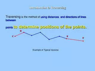
Procedure N (mag) A E D B Grass C Assume that you wanted to map “calculate coordinates of the building, trees, and the fence in the drawing, you are given points A and B only, cannot measure angle and distance to corner F or the trees!! • You need to construct new control points “points of known precise coordinates” such as C, D, and E to measure from. • You do that with a traverse F
Procedure N (mag) A E D B Grass C • Walk around and decide which are the best locations to have new control points • Construct the points, nails on asphalt, concrete and bolts, etc. • Measure all the angles and all the lengths of the traverse • Check if the angles and lengths are accepted • If rejected, re-do the work • If accepted, adjust the errors and compute coordinates.
Coordinate Computations • Assume that we were given a site to map, and the coordinates of one point (A), and the azimuth of the line (AB), we need more known (control stations) • We marked three more points around the site, the four points make rectangle (or a square). • We then measured all the internal angles and the length of all the sides (lines). • Using the given azimuth of AB and all angles, we computed the azimuth of all the sides, we get the following table:
Questions Note that the coordinates of A when computed at the bottom of the table, are not the same as given coordinates. Also note the relationship between that error and the sum of Northings and Eastings. How do you explain that? Assume that the traverse was a perfect square of 100 m side length and oriented towards the north, what you notice in our measurements, and how can you relate that to the error in A?
B c ΔN=0.1 D A ΔE=0.3 The concept of Linear Closing Error Closing error = 0.32m Notice that if the corrections are ignored, the value of the errors will Appear when you re-compute the coordinates of the first point (A).
B c D A The concept of Angular Closing Error • Now let us assume the same perfect square of 90° angles and 100 m sides. When measured all lengths were correct, while the angle at B was in error by 10° when measured, the surveyor reported 100°. What happens? Here is the perfect traverse that we are trying to measure:
B c D A A’ The concept of Angle Misclosure • Here is how the measured traverse will look: Line AB was correct Line BC was correct, but angle A was wrong The rest of the lines and angles are correct
The concept of Closing Error • Error in angles OR error in distances will result in a closing error: last point will not be at the first point. • The problem is that we do not know where the errors are and how much each error? • Measurements are never exact, we always assume that we have errors in angles and distances. • Before we learn how to compute the errors and how to adjust for them, let us learn some issues with traverse
Closed and Open Traverses • A closed traverse is the one that starts and ends at known points and directions, whether the shape is closed or not • A closed traverse can be a polygon {closed shape} or Link {closed geometry-open shape
Closed (polygon or link) traverses Link Polygon
Open TRAVERSE True Location Observed Location ∆X=XB-XA A L1 L2 L3 L4 ∆Y=YB-YA L5 ∑∆YObserved B MX MY MXY ∑∆XObserved • Open Traverses are not used in engineering control applications, why? • The problem: there is no way to check the for the errors; you will have to accept whatever coordinates computed.
Traverse Notations • We will only cover the closed Traverse with interior angles measured.
T1 T3 B T4 T2 A Traverse Stations • Successive stations should be inter visible. • Stations are chosen in safe, easy to access places. • Lines should be as long as possible • To reduce the number of lines • Short lines will produce less accurate angles, the traverse gets distorted as shown below.
Traverse Stations • Angles should be as equal as possible and better be 30 to 150°, why???? • Lines should be and as equal as possible, Why? • Stations must be referenced to retrieve them if lost. We produce a “descriptive card” for each point Descriptive card for a traverse point
Traversing by Interior Angles • All internal angles and all horizontal distances are measured • Each angle is measured in direct and reverse, • Each angle is observed at least three times. • A line of known direction should either be given or assumed, what is a line with known direction? • If the line of known direction is not a member of the traverse, the angle to a traverse member should be measured. Why?
Closing Error In Traverses • We measure two values: angles and distances • Because of errors in both measurements, we get angle misclosure and linear misclosure ( closing error). • Both types of errors result in error in closure, we need a way to separate the error of angles from the error in distances to check and adjust them separately
B c D A A’ The concept of Angle Misclosure • Here is how the measured traverse will look: Line AB was correct Line BC was correct, but angle A was wrong The rest of the lines and angles are correct
Computations and Adjustments of Angle Misclosure • The sum of internal angles of a polygon of (n) points = (n - 2) * 180o • Angle misclosure = difference between the sum of the measured angles and the geometrically correct total for the polygon. • The misclosure is divided equally among the readings keeping in mind the measuring accuracy, and should be done at the beginning of the adjustment.
Judging The Angle Misclosure • Usually the standards give an equation of the form: • Max allowed angle misclosure c = k * n where (n) is the number of points and K is a constant defined according to which standards used • If angles are accepted, correct by dividing the error equally among the angles • For example: The Federal Geodetic Control Subcommittee: 1.7, 3, 4.5, 10, and 12” for first-order, second-order class I, second-order class II, third-order class I, third-order class II
B c ΔN D A ΔE The concept of Linear Closing Error Assume that the traverse in reallity was a perfect square. Assume that there was an error in measuring the length AB only, all other lengths and angles were correct A’ - A will close at A’, - AA’ is the linear closing error
ECD EDA EAB EBC N - ve - ve D C A B E If the traverse is closed, then ΔE = 0 and ΔN = 0 + ve + ve
ECD EDA EAB EBC N - ve - ve D ΔN C ΔE If the traverse is closed, then ΔE = 0 and ΔN = 0 A’ A B E If the traverse is not closed, + ve + ve Then ΔE = Ec and ΔN = Nc
Computations of Linear Closing Error • If he closing error is (W) then Ew = ΔE and Nw = ΔN, W = length of closing error = Ew2 + Nw2 Fractional Closing error = traverse precision = W / L Direction of the error = Azimuth = tan-1 (Ew / Nw) = tan-1 (ΔE / ΔN)
Adjustment of Linear Misclosure • Compute and adjust the angle misclosure • Compute the linear misclosure: • Compute the azimuth of a traverse side • Compute the azimuth of all the sides • Compute the departure and latitude of all the sides • Compute the Misclosure in (E) direction = sum of the departures. • Compute the Misclosure in (N) direction = sum of the latitudes. • Compute the linear misclosure • If accepted, use the Compass (Bowditch) rule to adjust:
Correction in departure for AB = -( Correction in latitude for AB = -( )(LAB) )(LAB) ΔE ΔN L L Compass (Bowditch) Rule • Where: • L is the length of a line, and ( L) is the perimeter. • - Advantages and disadvantages of this method
Computations of Coordinates • Add the corrections to the departure or the latitude of each line to get the adjusted departure or latitude (maintain signs) • Compute the adjusted point coordinates using the corrected departure or latitude: Ei = E i-1 + ΔE Ni = N i-1 + ΔN • Check that the misclosure is zero.
Example of Standards Horizontal Control Accuracy Standards For Traverse (By The Federal Geodetic Control Subcommittee (FGCS))
=(0.54/2466.06)x285.1 =(0.72/2466.06)x285.1
Other Methods • There are several methods that are used to adjust or balance traverses; • Arbitrary method • Transit rule • Least-Squares method
Traverse Area C D B E A Traverse area = 1 S { Ei (Ni+1 - Ni-1)} 2 • Multiply the X coordinate of each point by the difference • in Y between the following and the preceding points, half the sum • is the area • The formula will work for traverses lettered in a clockwise direction, but it will give a correct area with a negative sign. • The formula should work if you switch the N and the E.
Example • Calculate the area of a traverse whose corners are (100,100), (300,100), (300,300), (100,300).