Download
1 / 7
270 likes | 1.46k Views
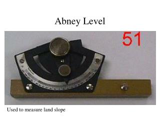
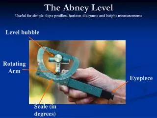
Level bubble. Rotating Arm. Eyepiece. Scale (in degrees). The Abney Level Useful for simple slope profiles, horizon diagrams and height measurements. Viewing side. Rotate arm to align Level bubble. Align bubble with this line. Target eg staff. Mirror side.

E N D
Level bubble Rotating Arm Eyepiece Scale (in degrees) The Abney LevelUseful for simple slope profiles, horizon diagrams and height measurements
Viewing side Rotate arm to align Level bubble Align bubble with this line Target eg staff Mirror side The Abney LevelView Through The Eyepiece
Measured angle Equal length poles Slope Profiling Abney level Slope distance
Useful Notes For Profiling • Take measurements at changes in slope and at points of interest (eg swampy areas, erosion sites etc) • Follow the line of steepest slope (this will mean your line is not straight) – but do avoid dangerous slopes or cliffs • Try to keep the staffs vertical when measuring • Take care when winding the tape measures or they will jam or break • Use tape to measure slope distance • Use Trig to calculate horizontal and vertical distances for plotting cross sections
Horizon Diagrams • Used at specific sites to quantify the shape of the horizon • When matched with sun path, gives indication of possible light levels at a site (therefore susceptibility to frost, suitable plants for a site etc) • Can be a useful way of considering how topography may affect wind patterns
Centre rep. Straight up, ie 90o elevation Outer ring rep. horizon Azimuth = 270 Elevation = 030 Horizon Diagrams 000o 315o 045o 270o 090o 225o 135o 180o
Measured angle Abney level Ht hpole Measuring the height of a tree Measured distance (d) eg 20m Hint: use a larger distance for a taller tree to make things easier Htree = hpole + (tanθ.d)