Download
1 / 16
160 likes | 251 Views
This study delves into the hydrological results from the Asu catchment, looking at factors like rainfall, groundwater storage, and soil moisture. Detailed measurements and key features of the catchment are examined in various contexts. The findings offer insights into the dynamics of this permeable catchment and its relation to storm flow and base flow. Conclusions highlight the significance of catchment characteristics in determining water balance.

E N D
Looking at the hydrological results from the Asu catchment in a wider contextHodnett, M.G1., Tomasella, J2., Cuartas, L.A2., Waterloo, M.W1., Nobre, A.D3, Mota de Oliveira, S3. and Múnera, J.C31 VU, Amsterdam, 2CPTEC, INPE3INPA, Manaus
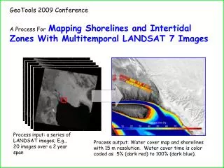
Asu catchment results examined in a wider context Location (Landsat)
Asu catchment results examined in a wider context Catchment information
Asu catchment results examined in a wider contextMeasurements • Rainfall • Runoff • Groundwater storage • Soil moisture storage • Interception • Evaporation fluxes • CO2 fluxes • In streamflow, groundwater, throughfall • DOC • POC • Nutrients • CWD (coarse woody debris)
Asu catchment results examined in a wider context Cross-section along hydrological transect
Asu catchment results examined in a wider contextSchematic diagram showing processes In very large events only - possible return flow & surface runoff (in convex areas) Throttle layer Clay cap 50% clay Variable contributing area 50m Main (perm. saturated) contributing area Deep drainage/recharge Phreatic surface Sand Groundwater discharge to stream Year Rain Baseflow % Stormflow % (mm) (mm) (mm) 2002 2975 744 55 618 45 2003 2054 540 69 241 31
Asu catchment results examined in a wider contextKey features of Bacia Asu • Deeply weathered and permeable catchment • Large storage in deep unsaturated zone (up to 36 m deep) • Large storage in saturated zone • Long time constant of drainage from this storage • Valley floor area ~35% • kept near saturation by ground water discharge • main source of storm runoff (& DOC) • Baseflow has very little DOC • Some evidence of contribution from slopes (in v. large events)
Asu catchment results examined in a wider contextMoisture storage changes beneath the plateau
Asu catchment results examined in a wider contextStorage in saturated zone -Groundwater levels at different distances from the stream 0 – 230m - valley floor 272 m - foot of slope 403 – 780m - plateau
Asu catchment results examined in a wider contextRelation of stormflow to catchment area for studies near Manaus
Asu catchment results examined in a wider context Figure modified from Lesack (1993)
Asu catchment results examined in a wider context Figure from Chauvel et al.(1987)
Asu catchment results examined in a wider contextCatchment form – DEMs from map and shuttle radar Digitised topog. map MI 517/2 Shuttle X-SAR Radar E E W W
Bacia Modelo Asu
Asu catchment results examined in a wider context Conclusions • Results apply to deeply weathered permeable catchments • Balance between storm flow and baseflow depends on proportion of catchment area which is valley floor with a shallow watertable • Results from very small catchments cannot be scaled up directly without taking this into account • Interflow / return flow on slopes may depend on presence of “clay cap” – not known how widespread this is • Much geomorphological variation on the Barreiras sediments N of Manaus – range of valley forms in different areas.
Asu catchment results examined in a wider contextResults continued • In areas with a shallow depth of weathering: • much less storage • less baseflow (quantity and duration) • soil / weathered zone may fill to the surface creating very large contributing areas