Download
1 / 13
150 likes | 396 Views
Using Landsat Satellite Imagery to Calculate a Vegetation Index in ArcGIS. Eric Rafn and Bill Kramber Idaho Department of Water Resources October 20 th 2011. Presentation Overview. What is NDVI? NDVI uses. ET calculation. NDVI tool. Download free Landsat imagery. What is NDVI?.

E N D
Using Landsat Satellite Imagery to Calculate a Vegetation Index in ArcGIS. Eric Rafn and Bill Kramber Idaho Department of Water Resources October 20th 2011
Presentation Overview. • What is NDVI? • NDVI uses. • ET calculation. • NDVI tool. • Download free Landsat imagery.
What is NDVI? • What is NDVI? • Normalized Difference Vegetation Index • Uses visible red and near-infrared wavelengths. • How does NDVI work? • Chlorophyll strongly absorbs visible red wavelength. • Plant structure strongly reflects near-infrared wavelength.
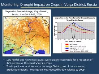
NDVI Uses. • Why use NDVI? • Characterize land cover. • Observe plant health. • Classify land as irrigated or not. • Estimate evapotranspiration.
ET Calculation. • Crop coefficient (Kc) = fraction of climatic demand of the atmosphere that is actually used to evaporate and transpire water. • Kc calculated using NDVI is a: • valid, • rapid, and • low cost method to calculate ET when energy balance methods are not available (i.e. SEBAL and METRIC). • Large spatial area. • Full season irrigation. For example: Kc = 1.1875 * NDVI + 0.05
ET calculation, cont’d. • Reference ET (ETref) = an index of climatic demand. • Meteorological data needed to calculate ETref. • ETcrop = ETref * Kc
Development of NDVI tool. • Developed NDVI tool using Python and ArcGIS 10. • Calculates top-of-atmosphere reflectance (Chander et.al 2009). • spectral radiance, and • top-of-atmosphere reflectance. • NDVI = (NIR – Red) / (NIR + Red).
NDVI tool. • Inputs. • Landsat band 4 and band 3. • Metadata • satellite name, • date, • sun elevation, • value ranges (LMIN and LMAX, Qcalmin and Qcalmax). (Note: downloaded satellite imagery only. Also, ArcGIS 10, ArcInfo license level, and Spatial Analyst extension are required.)
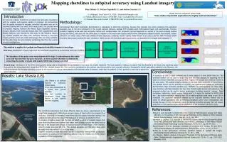
Compare NDVI. • Compare NDVI tool against METRIC NDVI. • Subtracted NDVI rasters (difference raster), • Performed Zonal Statistics with slope raster and difference raster, • Similar NDVI values on flat agricultural lands.
Download Landsat imagery, cont’d. • USGS Global Visualization Viewer (recommended website). • Simple. • User-friendly. • USGS EarthExplorer (alternative website). • Detailed search. • Download. • No processing - Some satellite scenes are ready for immediate download. • Pre-processing - Some satellite scenes require a free order submission and download (~1-3 days).
Download Landsat imagery, cont’d. • Unzip the downloaded file. • Unzip twice (*.tar.gz & *.tar). • Contains Landsat bands and metadata file. • Obtain and add ArcToolbox • Obtain “z_NDVI.tbx” and “How To” document.
Thank You! Eric.Rafn@idwr.idaho.gov