Download
1 / 14
140 likes | 416 Views
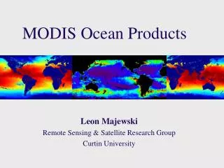
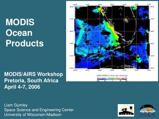
MODIS Ocean Products. MODIS/AIRS Workshop Pretoria, South Africa April 4-7, 2006 Liam Gumley Space Science and Engineering Center University of Wisconsin-Madison. MODIS Ocean Standard Products. MODIS Atmospheric Correction for Ocean Bands Statement of the problem:

E N D
MODIS Ocean Products MODIS/AIRS Workshop Pretoria, South Africa April 4-7, 2006 Liam Gumley Space Science and Engineering Center University of Wisconsin-Madison
MODIS Atmospheric Correction for Ocean Bands Statement of the problem: Total radiance observed by the satellite is composed of 5-10% ocean signal and 90-95% atmosphere signal. The atmospheric and ocean surface scattering effects must be accurately modelled and removed. Desired parameter is normalized water leaving radiance (nLw) for MODIS bands 8, 9, 10, 11, 12, 13 (0.412, 0.443, 0.488, 0.531, 0.551, 0.667 microns) Aerosol model selection: Assume zero (or negligible) water leaving radiance in the NIR bands (15 and 16; 0.750 and 0.865 microns); remainder is from aerosols. This is extrapolated to visible wavelengths using aerosol models. For case 1 waters, NIR bands are used to select aerosol model. Where this assumption is not valid, water-leaving radiance in NIR bands is estimated and removed prior to aerosol model selection.
Clouds Clouds Atmospheric correction is critical for ocean color retrievals • Lw is only 5-10% of signal reaching satellite: rest due to Lp • Lp components: molecular (Rayleigh) & aerosols
MODIS Chlorophyll Algorithm (OC3) Semi-analytical algorithm(1) Chl_a = 10**(0.283 - 2.753*R + 1.457*R2 + 0.659*R3 - 1.403*R4) where: R = log10((Rrs443 > Rrs488) / Rrs551) Rrs = nLw / F0; remote sensing reflectance F0 = extraterrestrial solar irradiance nLw = water leaving radiance at 443, 488, 551 (1) Performance of the MODIS Semi-analytical Ocean Color Algorithm for Chlorophyll-a Carder, K.L.; Chen, F.R.; Cannizzaro, J.P.; Campbell, J.W.; Mitchell, B.G. Advances in Space Research. Vol. 33, no. 7, pp. 1152-1159. 2004
MODIS Shortwave Infrared Sea Surface Temperature (c5) sst4 = a0 + a1 * BT39 + a2 * dBT + a3 * (1.0/mu - 1.0 ) where: dBT = BT39 - BT40 BT39 = brightness temperature at 3.959 um, in deg-C BT40 = brightness temperature at 4.050 um, in deg-C mu = cosine of sensor zenith angle a0, a1, a2, and a3 are time dependent coefficients derived from match-ups between observed MODIS brightness temperature and field measurements of SST. Note: sst4 is not valid during daytime because of solar reflection.
MODIS Longwave Infrared Sea Surface Temperature (c5) dBT <= 0.5 sst = a00 + a01*BT11 + a02*dBT*bsst + a03*dBT*(1.0/mu - 1.0) dBT >= 0.9 sst = a10 + a11*BT11 + a12*dBT*bsst + a13*dBT*(1.0/mu - 1.0) 0.5 < dBt < 0.9 sstlo = a00 + a01*BT11 + a02*dBT*bsst + a03*dBT*(1.0/mu - 1.0) ssthi = a10 + a11*BT11 + a12*dBT*bsst + a13*dBT*(1.0/mu - 1.0) sst = sstlo + (dBT - 0.5)/(0.9 - 0.5)*(ssthi - sstlo) where: dBT = BT11 - BT12 BT11 = brightness temperature at 11 um, in deg-C BT12 = brightness temperature at 12 um, in deg-C bsst = Either sst4 (if valid) or sstref (from Reynolds OISST) mu = cosine of sensor zenith angle a00, a01, a02, a03, a10, a11, a12, a13 derived from match-ups
The official NASA MODIS ocean processing algorithms are implemented in the SeaWIFS Data Analysis System (SeaDAS). SeaDAS is a comprehensive freely available software package for the processing, display, analysis, and quality control of ocean color and SST data. http://oceancolor.gsfc.nasa.gov/seadas/
SeaDAS MODIS Features: • L0 to L1A Direct Broadcast (DB) processing • L1A and Geolocation processing (DB or DAAC) • L1A to L1B processing • L1B to L2 processing (ocean color and SST) • L2 and L3 binning • SMI (Standard Mapped Image) creation
SeaDAS General Features: · User-controlled display scaling · Multiple frame buffers for image display · Interactive annotation generation · Histogram and color bar · Color manipulation, multiple concurrent color tables, density slicing · Cursor location and data displaying · Image data spreadsheet for raw and/or geophysical values · Image looping/movie · Scatter plot/contour plot/profile plot · Data display across multiple bands · Bathymetry generation · Arithmetic band functions · X-Y shifting · User-defined band operations · Postscript, PNG output image formats. · ASCII, HDF SD, and binary flat file output data formats.