Download
1 / 13
130 likes | 205 Views
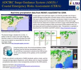
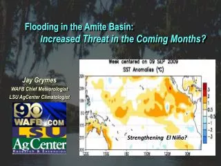
Explore the potential threat of increased flooding in the upcoming months in the Amite Basin due to climatic signals like El Niño. Analysis of historical rainfall data, flood events, and river stage data suggests a possible heightened risk, especially near Denham Springs.

E N D
Flooding in the Amite Basin: Increased Threat in the Coming Months? Jay Grymes WAFB Chief Meteorologist LSU AgCenter Climatologist Strengthening El Niño?
Flooding in the Amite Basin: Increased Threat in the Coming Months? -- reviewed daily mean stage for ‘Amite nr Denham Springs’ for the period Oct 1974 – present . . . data courtesy of USGS, Louisiana -- “flood events” defined as at least one day with daily mean stage ≥ 29.0 ft -- “moderate flood” defined as at least one day with daily mean stage ≥ 35.0 ft -- “major flood” defined as instantaneous stage ≥ 39.0 ft
Nov-to-Mar Rainfall: Departure from Normal El Nino Winter/Springs: 1950 - 1995 Rainfall Below Normal Rainfall Above Normal
El Niño ‘Signature’ along the Gulf Coast: ‘Active’ Sub-Tropical Jet Sub-Tropical Jet More Frequent Gulf Lows “Warm” SSTs
December-thru-May Rainfall: Louisiana EC Climate Division 1974-75 thru 2009-10 El Niño La Nada “Neutral” El Niño/Southern Oscillation (ENSO) Ranking La Niña Series Median 6-mo. Rainfall (in.) Seasonal rainfall tends to be greater during El Niño events Rainfall Data: NOAA/National Climatic Data Center ENSO Ranks: NOAA/NWS Climate Prediction Center
Amite River near Denham Springs Flood Events: Oct 1974 – Present by Month 51 Events -- 4 as ‘tropical’ -- 3 in summer/fall ‘Babe’ (1977) ‘Juan’ (1985) ‘Allison’ (2001) ‘Gustav’ (2008) River Stage Data: USGS, Louisiana
Amite River near Denham Springs Flood Events: Oct 1974 – Present by Month 51 Events Apr 1977 & Apr 1983 . . . ‘major’ floods . . . both during El Niños 1983 1977 1990 ‘Major’ Floods: > 39 ft River Stage Data: USGS, Louisiana
Amite River near Denham Springs Flood Events by Year: 1974 – Present (All Months) River Stage Data: USGS, Louisiana
Amite River near Denham Springs Flood Events by Year: 1974 – Present (December thru May) ‘Major’ Floods: > 39 ft River Stage Data: USGS, Louisiana
NWS/CPC ENSO ONI Index: Jan-Feb-Mar Index Score 35 Seasons: 9 El Niños & 9 La Niñas El Niño La Niña ONI Index: NWS Climate Prediction Center
NWS/CPC ENSO ONI Index: Jan-Feb-Mar Index Score & Occurrences of Winter/Spring Floods 5 El Niños: 16 floods in 9 seasons 1 El Niño 1 2 3 1 1 0 2 La Niñas: 5 floods in 9 seasons 0 1 1 0 0 1 0 0 2 La Niña No ‘moderate’ to ‘major’ floods La Nadas: 23 floods in 17 seasons ONI Index: NWS Climate Prediction Center
Flooding in the Amite Basin: Increased Threat in the Coming Months? While flooding in the coming months is not a certainty, climatic signals (El Niño) point to an elevated threat of ‘high water’ along the Amite near Denham Springs . . . and therefore much of the greater Amite Basin.