Download
1 / 23
230 likes | 312 Views
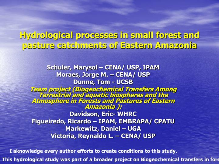
Hydrological processes in small forest and pasture catchments of Eastern Amazonia. Schuler, Marysol – CENA/ USP, IPAM Moraes, Jorge M. – CENA/ USP Dunne, Tom - UCSB

E N D
Hydrological processes in small forest and pasture catchments of Eastern Amazonia Schuler, Marysol – CENA/ USP, IPAM Moraes, Jorge M. – CENA/ USP Dunne, Tom - UCSB Team project (Biogeochemical Transfers Among Terrestrial and aquatic biospheresand the Atmosphere in Forests and Pastures of Eastern Amazonia): Davidson, Eric- WHRC Figueiredo, Ricardo – IPAM, EMBRAPA/ CPATU Markewitz, Daniel – UGA Victoria, Reynaldo L. – CENA/ USP I aknowledge every author efforts to create conditions to this study. This hydrological study was part of a broader project on Biogeochemical transfers in forest and pastures.
How land use change will affect hydrological processes at small catchment scale? These are springs located in a forested catchment and in a pastured one in Paragominas.
Hypothesis Land use change (forest/pasture) effects on hydrological fluxes processes at small catchment scale are: • Root zone soil permeability is reduced. • Increment in overland flow and subsurface flow. • Decrease of pasture evapotranspiration, and increment of soil water storage. • Water balance partitioning among different processes is altered. In order to verify these hypothesis, we selected 2 catchments: one forested and the other pasture covered. Both catchments are located at Paragominas county, state of Pará, Eastern Amazonia.
Paragominas (Fazenda Vitória) Igarapé 54 60 0 60 meters contour (0.5 m) stream weir in pasture 20 0 20 meters weir in forest contour (0.5 m) wells IKONOS satellite imagery: Fazenda Vitória, Paragominas, PA. In two selected catchments we installed equipments to measure flow of their ephemeral streams. We used wells to observe water table depth and collect samples to water chemistry analysis. Water table is deep enough to have no influence on the ephemeral streams flow.
Forest Forest catchment TDR and Ksat 6 m-depth soil pits Capoeira Fallow Plot Pasture 8 - 10 m 45 m Plynthite layer Pasture catchment 1 - 2 m Water Table Deep percolation Igarapé 54 (stream) . Schematic of hillslope and catchments location. The soil has a plynthite layer and its depth variesfrom8-10 m, on the top of hillslope, to few centimeters or surface, at footslope.
pluviometer wood boundary (2x2 m) surface runoff collector reservoir Ksat transects well meteorological station water table OVF + SSF collectors OVF collector weir surface runoff collector hillslope soil plastic cover gravel 90cm plastic plate subsurface flow collector Schematic of monitored catchment: met station, hydraulic conductivity transects, outlet weir, wells, overland flow and subsurface flow collectors. Let’s see each equipment.
We had a met station, pluviometers next to each catchment and throughfall collectors. Weirs were equipped with pressure transducer water level and Ksat measured using Guelph permeater.
Forest Pasture • Subsurface flow • Overland Flow Four overland flow collectors at 2 m x 2 m plots installed in each catchment. A 2 m-length pit (0.9m-depth) was located downslope a 12 m slope in each catchment, These pits had a subsurface flow collector at 0.9 m-depth (plynthite layer) and an overland flow collector.
Pe = P - I gs ET OVF S i+1 sat cc w D DS = P- I- ET- OVF - D Water Balance Equation Model • Evapotranspiration • Penman- Monteith • Stomatal Conductance - Jarvis-type model(1976) • Soil water storage • Van Genuchten Equation • Water balance equation A bucket model based on water balance equation, with evapotranspiration estimated by Penman-Monteith formula, with surface conductance from a Jarvis-type model estimate. Soil water storage was calculated by water balance and compared to estimates from tensiometers measurements. Tension was related to soil moisture applying Van Genuchten equation on soil retention curves.
Soil texture along the hillslope Soil texture and classification showed 4 different types of soil along the hillslope. Forest and pasture catchmentswere located in different positions in the hillslope. Forest one is upslope and pasture is on lower mid-slope. Footslope has gleissolo.
Forest – Latossolo with Plynthite signs at 1 m depth Pasture - Plintossolo Forest site was on Latossolo (Oxyssol), with a plynthite layer around 0.90 m-depth. Pasture, in a lower position in the hillslope, is on Plintossolo (Ultissol) with pliynthite signs since 0.40 m-depth.
Box-plot results of Ksat as a function of depth, under forest (a) pasture (b) and (c) capoeira. The length of the box represents the sample interquartile range, the cross bar in the box the sample median, the notch its 95% interval and the circles the outlying data points defined as being larger than 1.5 times the interquartile range. Saturated hydraulic conductivity (Ksat) presents high variability. In forest, Ksat on surface reached high values (23 mm h-1, median). In pasture, we observed the lowest values for Ksat. In capoeira, intermediate values at surface Ksat showed soil physical properties restoration signs only at surface. Note the different graph scales.
Overland flow and Subsurface flow Pasture Forest Results of overland flow shows ratio OVF: total precipitation around 0.04 (4%) while ratio for pasture is 14%. In both land cover, SSF measured was ~1% precipitation.
Pastagem Floresta Tension data set for different depths (0.15, 0.3, 0.6 and 0.9m) during wet season, shows that most of the days soil is near saturation. This is markedly observed in pasture, while in the forest tensions reach lower values due to free drainage.
Mean soil water content for wet season in the pasture (blue diamonds) were higher than water content in the forest soil plots (circles). This difference is markedly observed near surface (0.15 and 0.30 m).
P P ET ET I I Pe Pe OVF OVF qv qv Plant water uptake Plant water uptake SSF SSF S S qv qv R R Water Balance Changes Forest Pasture Changes inWater balance components: Interception decreases, while there are increments in Evapotranspiration, Overland Flow and Soil water Storage increase. Although we did not measure Recharge,it should increase due to larger soil water Storage.
Conclusions Land use change (forest/pasture) effects on hydrological fluxes processes at catchment scale are: • Root zone soil permeability is reduced. • Increment of overland flow and possibly subsurface flow. • Decrease of pasture evapotranspiration, and increment of soil water storage. • Water balance partitioning is altered within different components.
Observations for future studies Besides soil class, the presence and depth of hydraulic impeding layers is related to the position in landscape (hillslope height). The presence of an impeding layer (plinthite, e.g.) may increase forest-pasture conversion effects on hydrological processes, as ET reduction or OVF increment. Could soil hydraulic properties as driving forces on hydrological changes related to forest conversion be modelled from landscape features?
Relations to Biogeochemistry Higher cations and anions concentrations in stream water during wet season are related to Overland Flow, that increases after forest conversion. How much is nutrients exports in these areas? Forest conversion should have different soil responses according to landscape position and hydraulic properties. How can we model these influences on nutrient exports? For example, rivers with large floodplains and others with steeper mid-slope have different hydrological processes driving geochemistry fluxes.
Vertical and Subsurface Flow Veg: Forest Overland flow Hortonian OVF- pasture return flow - forest Overland flow on saturated areas Well Drained plinthite Draining impeded plynthite layer No drainage, saturated area Water table Latossolo Amarelo Plintossolos Gleissolo