Analysis of Ocean Currents and Transport in Pacific Region: Kuroshio and Taiwan Strait
This research evaluates the seasonal transport and currents within the Kuroshio Current and Taiwan Strait, utilizing ship ADCP data and comparisons with satellite observations. It investigates mean values and standard deviations through various transects and aims to identify significant transport features, including seasonal variations and the dynamics of upper and lower water columns. The findings will support PhD entrance requirements and contribute to the broader understanding of oceanic transport patterns impacting the Luzon Strait and the South China Sea.

Analysis of Ocean Currents and Transport in Pacific Region: Kuroshio and Taiwan Strait
E N D
Presentation Transcript
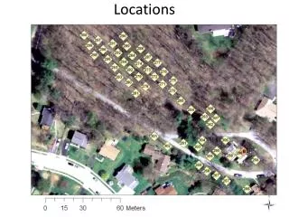
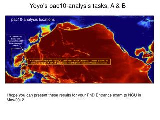
Yoyo’s pac10-analysis tasks, A & B pac10-analysis locations B. Compare in details with Taiwan ship-ADCP Data: seasonal means. A. Compare in details with satellite in Luzon Strait & South China Sea: 1. means & StdDs: xy-contours (maps) both SSHA & geostrophic currents (mean+variance ellipses); 2. seasonal I hope you can present these results for your PhD Entrance exam to NCU in May/2012
Alu’s pac10-analysis STCC pac10-STCC analysis Means, eddies + PV etc: is there an STCC in the model? Alu, you have read many papers – so now you can apply what you have learned. BTW, I still want you to finish up your idealized case – do that first for OSM!! Write a DRAFT paper based on what you have.
pac10-analysis: transects A-G G. Tsushima Strait transport D. Transport through the Taiwan Strait – mean & seasonal: ship ADCP H. JMA-Section (137oE,3-34oN) E. Kuroshio Transport at PN-line, mean & seasonal B. Compare in details with ADCP’s: means & StdDs: 1. xz-contours; 2. Transport time-ser + mean & StdD; Johns, W.E., T.N. Lee, D. Zhang and R. Zantopp, 2001: The Kuroshio east of Taiwan: moored transport observations from the WOCE PCM-1 array. J.Phys.Oceanogr., 31, 1031–1053. C. Flows across the Luzon Strait – upper & lower & whole, mean & seasonal A. Kuroshio Transport off Luzon at ~18N, mean & seasonal – see Sheu, Wu & Oey (2010) F. Karimatan Strait: transport
pac10-analysis: transects A-G G. Tsushima Strait transport D. Transport through the Taiwan Strait – mean & seasonal: ship ADCP E. Kuroshio Transport at PN-line, mean & seasonal B. Compare in details with ADCP’s: means & StdDs: 1. xz-contours; 2. Transport time-ser + mean & StdD; Johns, W.E., T.N. Lee, D. Zhang and R. Zantopp, 2001: The Kuroshio east of Taiwan: moored transport observations from the WOCE PCM-1 array. J.Phys.Oceanogr., 31, 1031–1053. C. Flows across the Luzon Strait – upper & lower & whole, mean & seasonal A. Kuroshio Transport off Luzon at ~18N, mean & seasonal – see Sheu, Wu & Oey (2010) F. Karimatan Strait: transport
IHOS - Taiwan Ocean Prediction (TOP) Research Highlights; Oct/20/2011; by L.Oey. • IHOS is developing an ocean current and wave prediction model: the Taiwan Ocean Prediction (TOP) system that eventually will include also air-sea (with typhoons) and air-sea-ice coupling, as well as biogeochemical processes. Three recent publications and an example of the simulated SST over the entire North Pacific Ocean are given below. • Chang, Y.-L. & L.-Y. Oey, 2011: The Philippines-Taiwan Oscillation: Monsoon-Like Interannual Oscillation of the Subtropical-Tropical Western North Pacific Wind System and Its Impact on the Ocean. J. Climate, in press. PDF Format. Download PTO Data (text file) here. • Chang, Y.-L., and L.-Y. Oey, 2011: Interannual and seasonal variations of Kuroshio transport east of Taiwan inferred from 29 years of tide-gauge data, Geophys. Res. Lett., 38, L08603, doi:10.1029/2011GL047062 • Fujisaki, A. and L.‐Y. Oey, 2011: Formation of ice bands by winds, J. Geophys. Res., 116, C10015, doi:10.1029/2010JC006655. TOP sea-surface temperature (SST) on Jun/06/1988 during the developing stage of the strong 88-89 La Niña when waters as cold as 19oC is simulated in the eastern equatorial Pacific in excellent agreement with observation (http://www.pmel.noaa.gov/tao/elnino/la-nina-story.html#). TOP also simulates a beautiful meandering Kuroshio that separates off the eastern coast of Japan, as well as the intrusion of very warm waters (SST≈31oC) into the South China Sea through the Luzon Strait. (From Lu, H.-F. & L.-Y. Oey, 2011: Instability waves and eddies of the Subtropical Counter Current in the North Pacific Ocean, Manuscript in preparation).
pac10-analysis locations B. Compare in details with Taiwan ship-ADCP Data: seasonal means. C. Compare in details with ADCP’s: means & StdDs: 1. xz-contours; 2. Transport time-ser + mean & StdD; Johns, W.E., T.N. Lee, D. Zhang and R. Zantopp, 2001: The Kuroshio east of Taiwan: moored transport observations from the WOCE PCM-1 array. J.Phys.Oceanogr., 31, 1031–1053. A. Compare in details with satellite in Luzon Strait & South China Sea: 1. means & StdDs: xy-contours (maps) both SSHA & geostrophic currents (mean+variance ellipses); 2. seasonal