Download
1 / 13
130 likes | 248 Views
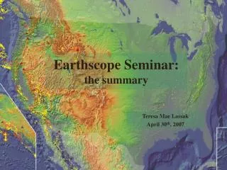
Earthscope Seminar: the summary. Teresa Mae Lassak April 30 th , 2007. Earthscope. Use arrays of data (geologic, seismic, exploration) to: Understand the structure, evolution and dynamics of North America. Enhance understanding of SAF. Better understand seismic and natural hazards.

E N D
Earthscope Seminar: the summary Teresa Mae Lassak April 30th, 2007
Earthscope • Use arrays of data (geologic, seismic, exploration) to: • Understand the structure, evolution and dynamics of North America. • Enhance understanding of SAF. • Better understand seismic and natural hazards. • “Investigate the relationship between mantle structure and dynamics, and crustal tectonics, and between tectonics and fluids in the crust.”
Focus regions • Cascadia • San Andreas Fault System • Colorado Plateau
Data/Techniques Used • Broadband seismic stations (Ambient noise) • Surface deformation data • Receiver functions • S-Wave triplications • Interferometric synthetic aperature radar (InSAR) • Magnetotelluric electrical resistivity data (MT) • Seismic reflection • Drilling • Gravity measurements
Cascadia • Geometry of subducted plate? • Earthquake prediction? • Papers: • Episodic Tremor and slip on the Cascadia subduction zone: The chatter of silent slip • G. Rogers and H. Dragert • High-Resolution Surface-Wave Tomography from Ambient Seismic Noise • N.M. Shapiro,M. Campillo, L. Stehly, and M.H. Ritzwoller • Low-Velocity Zone Atop the 410-km Seismic Discontinuity in the Northwestern United States • T.-R.A. Song, D.V. Helmberger, and S.P. Grand
Cascadia: Lingering Questions • Yellowstone: what is it? • plume? • or some thing else? • What is a mechanism for the flattening of a slab, and subsequent detachment? • How does a dehydrated slab detach and sink, and how does it affect the flow field in the mantle? • How could a plume could break through a slab?
San Andreas Fault System • Geology of SAF • Use both geology and seismology • SAFOD • Fluids? • Papers: • Fine-scale structure of the San Andreas fault zone and location of the SAFOD target earthquakes • Thurber, C., S. Roecker, H. Zhang, S. Baher, and W. Ellsworth • Internal structure of the San Andreas fault at Parkfield, California • Unsworth, M.J., P.E. Malin, G.D. Egbert, and J.R. Booker
SAF: Lingering Questions • Has SAFOD looked at fluids present in the rocks at depth. • Have there been porosity/permeability studies in the borehole? • Fluids… • Data shows a greater apparent resistivity measured parallel to SAF • Interpreted as a high porosity region with saline fluids in fault zone • Does that make sense? • How important is the source of fluids potentially present in SAF? • Fluids may be crustal, mantle, or meteoric. • Would fluid from different sources be more or less likely to assist in rupture?
Colorado Plateau • Origin of Colorado plateau thickening? • Injection of new material? • Other causes? • Farallon slab affect the uplift? • Papers: • Upper mantle structure beneath the eastern Colorado Plateau and Rio Grande rift revealed by Bouguer gravity, seismic velocities, and xenolith data • Roy, M., J.K. MacCarthy, and J. Selverstone • Raising the Colorado Plateau • McQuarrie, N., and C.G. Chase
CP: Lingering Questions • What is our best guess as to what caused the thickening of the Colorado Plateau? • How would basalt extraction from peridotite (which may leave a lower-density residuum) affect uplift?
Remaining questions… • Are surface deformations a manifestation of mantle influence on the lithosphere? If so where and how? • What types of integrated studies would help begin addressing problems related to our understanding of the crust and mantle within a system? • Detailed structure of the Moho, 410-, and 660-km discontinuities beneath the western US ? • What implications/relationship does boundary layer structure have for the surface tectonics of North America? • Are joint inversions utilizing the vast array of EarthScope data planned/in progress?
Remaining questions… • Does the group think that other nationwide geophysical exploration projects used in conjunction with Earthscope data would be beneficial to studying the NA continent? • a nation-wide gravity survey, • nation-wide EM survey, • etc… • How far will Earthscope go?