Download
1 / 30
360 likes | 1.03k Views
German scientist Alfred Wegener proposed the continental drift theory in 1912. Pangaea means “all Earth”. 225 million years ago 200 million years ago 135 million years ago. 65 million years ago Present day. 300 million years ago Pangaea video.

E N D
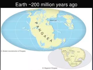
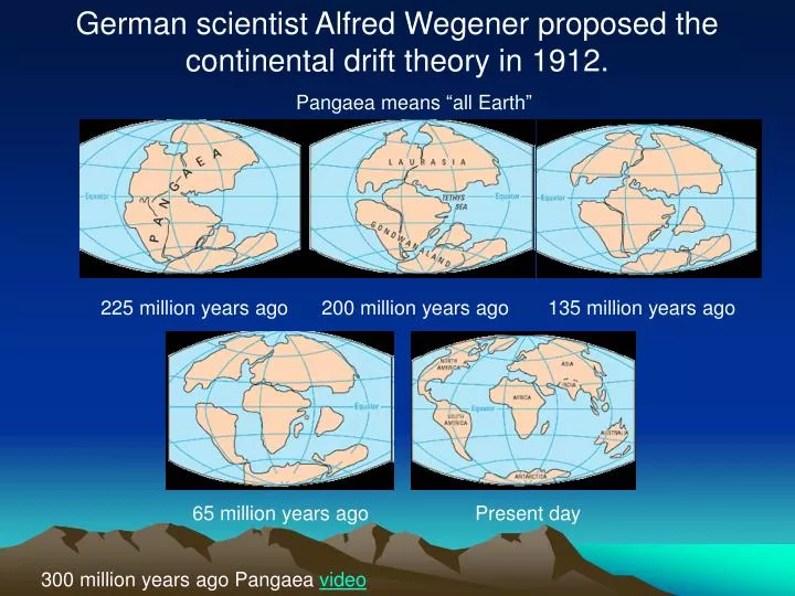
German scientist Alfred Wegener proposed the continental drift theory in 1912. Pangaea means “all Earth” 225 million years ago 200 million years ago 135 million years ago 65 million years ago Present day 300 million years ago Pangaea video
The World’s GeographyLesson 1 • What is geography? • The study of Earth and its people. • What does a geographer do? • Geographers study the Earth and its people.
The Continents 1. North America 2. South America 3. Europe 4. Asia 5. Africa 6. Australia 7. Antarctica
Landforms island • Naturally formed feature on the Earth’s surface. • Islands, mountains, plateaus, and plains are all examples of landforms. mountain plateau plains
The Oceans 1. Pacific Ocean 2. Atlantic Ocean 3. Indian Ocean 4. Arctic Ocean Water covers ¾’sof the Earth’s surface.
Climate • Climate is the weather • conditions in a place over • a long period of time. • Climate has a big • impact on vegetation. For example: In a jungle, plants grow well due to heavy rainfall and a tropical climate. However, crops may have a difficult time growing in a hot dry climate such as a desert. Jungle Desert
The Five Themes of GeographyGeographers are guided by two questions when studying the Earth: “Where are things located?” and “Why are they there?” so they use 5 themes to organize information. • Location (Relative & Absolute) • Place (Human and Physical features) • Region • Movement • Human-Environmental Interaction
Location - “Where are we?” Absolute Location – a place’s exact position on the Earth. • Local – street address Example: 6700 Auburn Road Painesville, Ohio 44077 (You’ve located LaMuth Middle School) • Global – latitude and longitude Example: 55 degrees north and 10 degrees east (You’ve located Hamburg, Germany) Relative Location – describes where a place is by describing places near it; described by landmarks, time, direction, or distance from one place to another. • Cleveland, Ohio is southwest of LaMuth Middle School. • Cleveland, Ohio is 45 minutesaway from LaMuth Middle School. • Cleveland, Ohio is 30 milesaway from LaMuth Middle School. • Cleveland Browns Stadium is directly behind the Science Center.
Place“What type of place is it?” Physical features: • Is the land hilly or flat? • Is the climate hot or cold? • What wildlife lives here? • Are there any bodies of water? Human features: • What types of buildings are built here? • Are their any roads? • What type of clothing do people wear here? • What type of food do people eat here?
RegionsAn area that has a unifying characteristic which is used for comparison Regions are created by people to more easily define places that share similar characteristics, such as: - Climate, Land, Population, History • Examples: • The Midwest, the South and New England • Riverside Local School District, zip code • The Rocky Mountains, the Great Lake States, the United States of America
Movement“How do people, goods, and ideas get from one place to another?” • The world interacts through travel, trade, information (media) and political events. • Helps explain cultural changes. • Do we depend on people in other places? • How do we move from placeto place? • How would our life change if we traveled by horse? • How do we actually get food?
Human / Environmental Interaction“How do humans and the environment affect each other?” How people affect their environment, the physical characteristics of their natural surroundings, and how their environment affects people. PEOPLE • Create dams or irrigation canals due to little rainfall • Build sprinkler systems • Cut down trees to create a neighborhood or road to travel ENVIRONMENT • Hurricanes in Florida • Earthquakes in California • Tornadoes in Kansas
The Five Themes of Geography“What are they again?” • Location (Relative & Absolute) • Place (Human and Physical features) • Region • Movement • Human-Environmental Interaction
The Geographer’s ToolsLesson 2 Globes: A circular representation of the Earth’s surface. It shows true shapes, locations, and relative sizes of the Earth’s landforms and bodies of water. Maps: A flat representation of the Earth’s surface. It can be drawn to any size. Advantages to Maps: • Measure distances • See the world at a glance • Easy to use -You can pick it up and carry it around!!
Mapmaking •Cartography - the art and practice of making maps •Cartographers - a person who makes maps, deciding which information to include and how it is to be displayed
Basic Issues in Map Design 1. Considering the purpose ofand audience forthe map: A cartographer must identify these things to determine how data are displayed, what map elements are included, and the general layoutand format of the entire map. Example: A map designed to be a teaching tool for third graders will obviously look different than a map designed to be included in a report for senators. 2. Choosing a map type: Cartographers must decide which map type (reference or thematic) will best show the map’s purpose. The type of data, audience, and geographic areaaffect this decision. Example: A map showing average rainfall over a region does not need to be cluttered by showing all roadways in the region
Basic Issues in Map Design 3. Selecting a title that represents what is shown: The title of the map should tell map readers, in a few words, what is important about the map. 4. Selecting and placing text: Text should be readable and easily locatedbut not interfere with the map’s data or design. Different font types, styles, sizes, and colors can be used to help. 5. Designing an overall layout for easy understanding: Cartographers have to consider the layout of all map elements to create a final product that is informative, accurate, and visually nice to look at. Example: A map showing average temperatures may use different colors to show the temperatures, with red representing the warmest areas
Reading a MapSymbol Video Seattle, WA
Mercator Map ProjectionMercator– shows most of the continents as they look on a globe. However, it stretches out lands at the north and south poles.
Homolosine Map ProjectionHomolosine – divides the ocean, is fairly accurate in showing landmasses, but distances are not correct.
Robinson ProjectionRobinson – often used in textbooks, are nearly true to size and shape. However, landforms at the north and south poles appear flat.
Which map projection stretches the continents the most? • Mercator projection • Homolosine projection • Robinson projection
Hemispheres • The earth is divided into equal halves. • The equator divides the north from the south and the prime meridiandivides the east from the west.
The Geographic Grid • Latitude and Longitude lines identify absolute location. • This absolute location uses a set of “coordinates” or numbers. • The coordinates are measured in degrees. Latitude Longitude
What two hemispheres is the United States located on? • Southern and Western • Northern and Western • Northern and Eastern • Southern and Eastern
What part of the geographic grid measures the directions east and west? • Longitude • Latitude
Maps for Different Purposes Political Mapsshow the features people have created, such as cities, states, provinces, territories, and countries.
Physical mapsshow landforms and bodies of water found in particular areas.
Thematic Mapsinclude certain information about a place or region.
What map shows landforms? • Thematic map • Political map • Physical map