Download
1 / 14
140 likes | 243 Views
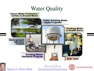
Water Quality. Water Quality . John Haines, USGS, Pixie Hamilton, USGS, Ru Morrison, NERACOOS, Mario Tamburri, ACT, Jawed Hameedi, NOAA NCOOS. Ru Morrison, NERACOOS Pixie Hamilton, USGS. Types of RA activities related to Water Quality . Data Services - simplifying access to data for users.

E N D
Water Quality Water Quality John Haines, USGS, Pixie Hamilton, USGS, Ru Morrison, NERACOOS, Mario Tamburri, ACT, Jawed Hameedi, NOAA NCOOS Ru Morrison, NERACOOS Pixie Hamilton, USGS
Types of RA activities related to Water Quality Data Services - simplifying access to data for users Observations, including support for partners Plume Tracking Customized Products
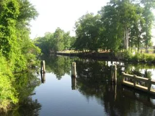
Beach Water Quality Assessment and Modeling Activities Issue: Exposure to beach swimming waters with elevated bacterial levels is a public health concern. Goal: Develop and implement scientifically-justified decision-support tools to for accurate and defensible preemptive advisory issuance decisions. Process: 1.) Data integration 3.) Model validation 4.) Operational decision-support tool 2.) Model development Who is doing it: Related work is taking place within 6 of the RAs.
Drinking Water Quality:Huron Erie Corridor Waterways Forecast System (HECWFS) • Goal: • Reduce health risks and costs associated with pollutant spills in the Lake Huron to Lake Erie Corridor • Major Elements: • Link 2d model for corridor to NOAA Great Lakes Forecasting System • Generate 3d public domain model • Use 3d model to support water intake risk assessment work
Water Quality and Ecosystems • Buoys: Capture high resolution temporal features • Unraveled controls of light penetration in Great Bay Estuary, NH helping protect critical eelgrass habitat through developing Nutrient Criteria DO light Chl & TSM nutrients • Unraveled causes and help predict low DO in the Long Island Sound • Gliders: Capture spatial features • DO Part of NJ water quality monitoring NJDEP, EPA, Rutgers, MARACOOS
Harmful Algal BloomsRapid Detection/Timely Forecasts Range of Observations Lifeguards w/smart phones, Shore stations, Moorings, Gliders , fluid imaging, Satellites Technology Development ACT workshops New sensors Analysis and Modelilng NOAA Forecasts
Bottom Water Dissolved Oxygen in the Gulf of Mexico Data source: N.N. Rabalais, Louisiana Universities Marine Consortium, R.E. Turner, Louisiana State University Funded by: NOAA, Center for Sponsored Coastal Research
Yield delivered to estuary from watershed, kg/yr/ha Eutrophic, influenced by nitrogen input
Technology to Meet User Needs • Technology Trends: • Affordable and accurate physical and chemical sensors • Sensors deployed on multiple fixed and moving platforms • Real-time data and communications • Technology Needs: • Improved spatial and temporal coverage • Reliable/robust sensors (e.g., antifouling) that are easy to use • Bio- and geno-sensors (from marine mammals to microbes) • ACT supports IOOS by: • Independent third-party testing for technology developers/manufacturers and users • Forum for communication and consensus on state of technology and user needs • Coastal and ocean technology information clearinghouse
Northeast Data Management and Portal (http://odpdx.neracoos.org)
NOS/National Centers for Coastal Ocean ScienceWater Quality-Related Portfolio Status Trends Modeling ecol. impacts Invasive species Source attribution Research/ discovery Weather & Climate Assessments Forecasting Volunteer monitoring
National Water Quality Monitoring Network for U.S. Coastal Waters and Their Tributaries (“Network”) • Continuum of observations in: • Estuaries • Near-shore waters • Off-shore waters • Great Lakes • Coastal beaches • Wetlands • Flow and flux from streams, groundwater, atmosphere
Discussion Questions • There are successes (in new technology and observation capabilities, data integration and interoperability, scientific analysis and modeling and decision support tools) around the country – at the regional and national levels. How do we transform these successes into a sustained national effort? What’s working that can be expanded right now? What are the gaps/challenges that is preventing a national effort. • 2. Data management provides a vehicle for the multitude of WQ providers to share data. How do we continue the progress made to date? How do we fund data management efforts? How to engage the broader interagency community and the larger community?