Download
1 / 59
590 likes | 619 Views
Learn about the LAPS system's high-resolution, portable design used globally in meteorology. Explore advanced data analysis and forecasting methods.

E N D
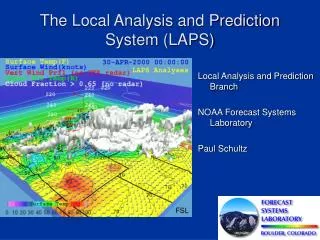
Local Analysis and Prediction System (LAPS) Update Steve Albers, Dan Birkenheuer, Isidora Jankov, Paula McCaslin Paul Schultz, Ed Szoke, Zoltan Toth, Yuanfu Xie, Linda Wharton LAPS Workshop October 25, 2010
LAPS Motivation • High Resolution (500m – 20km), rapid update (10-60min) • Highly portable system – about 150 users world wide • Federal Gov’t – NWS, RSA, PADS, FAA, DHS • State Gov’t – California Dept of Water Resoures • International – Finnish Met. Inst., China Heavy Rain Inst. • Global analysis – used by SOS • Wide variety • of data sources: OAR/ESRL/GSD/Forecast Applications Branch 2
LAPS DA-Ensemble System Data Data Ingest Intermediate data files Error Covariance Trans Traditional GSI Analysis Scheme STMAS3D Trans Post proc1 Post proc2 Post proc3 Model prep WRF-ARW MM5 WRF-NMM Probabilistic Post Processing Ensemble Forecast OAR/ESRL/GSD/Forecast Applications Branch 3
Wind Analysis using Doppler radial velocities Doppler Wind Obs
LAPS Cloud analysis C&V / Icing METAR METAR METAR OAR/ESRL/GSD/Forecast Applications Branch 6
FH FL LAPS HOT START INITIALIZATION Three-Dimensional Cloud Analysis METAR + FIRST GUESS
Satellite use in LAPS (GOES / SEVIRI*) • 11 micron IR • 3.9 micron data • Visible (with terrain albedo database) • CO2-Slicing method (Cloud-top pressure) • *2010 Paper with Italian Collaborators • Cloud-Drift Winds • Retrieved Soundings (T, Td) Cloud Analysis OAR/ESRL/GSD/Forecast Applications Branch 8
6-hr Diabatically (LAPS) initialized WRF-ARW forecast Analysis 13 June 2002 OAR/ESRL/GSD/Forecast Applications Branch 11
850 mb Analyzed and Simulated Reflectivity Analysis 2hr HOT Fcst 2hr NO-HOT Fcst 16 June 2002
LAPS 1km Grid Spacing 15 min. Wind Analysis with Observations and the Terrain included
LAPS 1km Grid Spacing 15 min. Fire Weather Index and Wind Analysis
Future DA Development - 1 • Higher Resolution Space / Time • 2km – 5 to 15min national analysis for FAA/COSPA • 1km or less for AWIPS-II WFO domain • 20-50 meter analysis for fire weather • Initialize WRF at high resolution for WFO domain • Develop forward models for all data sources being used to more fully implement a 4DVAR approach • Incorporate clouds/precipitation variationally into STMAS • subsequently feed into GSI • Dynamical Downscaling • consider hi-res terrain dependent flow in variational cost function • Use ensemble covariances in STMAS • Share methodologies between LAPS / STMAS / HRRR OAR/ESRL/GSD/Forecast Applications Branch 16
STMAS 2km CONUS 15-min update OAR/ESRL/GSD/Forecast Applications Branch 17
Future DA Development - 2 • Implement LAPS in AWIPS-II, transitioning to STMAS • Consider new data sources (e.g. GPS, radiometer, Level-II radar) • Some are available in “full” LAPS, so can be included for AWIPS as well • Acquire global geostationary & polar orbiter satellite radiances / imager data • Improve quality control (in LAPS/STMAS and upstream in MADIS) • More efficient net enabled data access (e.g. NNEW) • Full dynamic constraints in STMAS toward a multigrid 4DVAR analysis system with WRF adjoint system. OAR/ESRL/GSD/Forecast Applications Branch 19
Thanks! • More info at: http://laps.noaa.gov • Questions / Comments? OAR/ESRL/GSD/Forecast Applications Branch
Software Development • LAPS Workshop Oct 25-27, 2010 • More info (including Forum) at: http://laps.noaa.gov OAR/ESRL/GSD/Forecast Applications Branch
2.1 3.1 3.2 2.2 3.3 2.3 3.4 OAR/ESRL/GSD/Forecast Applications Branch 4.0 5.0
NOWRAD netCDF (Low-level Reflectivity) Level-II Broadcast Data (IRADS Network) Level-III AWIPS LAPS script (LapsRadar.pl) calls WFO program (tfrNarrowband2netCDF) GSD Central Facility Processing vrc_driver.x LAPS Radar Ingest Polar netCDF File (GSD “NIMBUS” Format) Remap_polar_netcdf.exe 2-D LAPS Grid Reflectivity (VRC) 3-D LAPS Grid Ref + Vel (VXX) Mosaic_radar.x (multiple radar input) 2-D LAPS Grid Reflectivity (VRC) 3-D LAPS Grid Reflectivity (VRZ)
Cloud Analysis (cloud.exe) Flow Chart Cloud Fraction 3-D Isosurface
Microphysics, Vertical Motion and Hot-Start (deriv.exe + accum.exe) LAPS hot-start scheme Dramatically improves Very short-range forecast, Importance to terminal Scale forecasts The hot-start scheme will be adapted into STMAS, a multi-grid variational data assimilation system with satellite, radar, conventional obs and model dynamic constraint applied simultaneously.
Analyzed Cloud Liquid vs WISP Aircraft measurements Envelope Indicates Good POD Scatter (FAR) due to unresolved small-scale LWC variability, otherwise good analysis of icing potential OAR/ESRL/GSD/Forecast Applications Branch 26
Balance Package Hatted quantities: solution increment Primed quantities: pre-balanced increment OAR/ESRL/GSD/Forecast Applications Branch 27
Future Cloud Analysis Development • Higher Resolution Time/Space • Develop forward models for all data sources being used to more fully implement a variational approach • Incorporate methodologies into STMAS & GSI • Consider new data sources (e.g. airborne radar) • Improve rain gauge / radar / model first guess blending for QPE OAR/ESRL/GSD/Forecast Applications Branch 28
Web Products • NCL/NCAR graphics based • Pre-Generated NCAR graphics • “Sched.pl –f” runs followup_ncarg.sh to generate GIF images • “On-the-fly” page • “nph-laps.cgi” script (etc/www) directory • Can be run on a web server • Publication quality imagery • Horizontal, vertical cross sections, soundings • Verify/overlay model forecasts with analyses and observations • Difference plots (e.g. analysis vs. first guess) • Animations (animated GIF / Java) • Montages (e.g. ensemble display through time) OAR/ESRL/GSD/Forecast Applications Branch
“On-The-Fly” Page OAR/ESRL/GSD/Forecast Applications Branch
“On-the-fly” Page Montage • “On-The-Fly” Page OAR/ESRL/GSD/Forecast Applications Branch
LAPS / STMAS Forum Discussion Forum OAR/ESRL/GSD/Forecast Applications Branch
Analysis software plans • Portability • Intel/ifort • GFORTRAN • Mac (Linux) • Parallelization • MPI works with Traditional LAPS wind analysis • STMAS minimization routine is next • GPU technology • Optimize & Vectorize serial code • Sub-Kilometer resolution • Hi-res Terrain / Land Use (incorporated in balancing constraints) OAR/ESRL/GSD/Forecast Applications Branch
Thanks! • More info at: http://laps.noaa.gov • Questions / Comments? OAR/ESRL/GSD/Forecast Applications Branch
Breakout Session – New Products OAR/ESRL/GSD/Forecast Applications Branch
Planning Categories • Traditional LAPS Analysis • LAPS Analysis (Traditional / STMAS) • LAPS Forecast / WRF OAR/ESRL/GSD/Forecast Applications Branch
Traditional Analysis Plans - 1 • Gauge Radar Blended Analysis(Steve) • Requested by FMI, Ed Tollerud • Domain wide radar/gauge bias option • Spatially varying bias option • Compare to NCEP (CPC and/or Stage IV), Steve Mullen techniques • Split off Cloud type from Precip Type(Steve, Dan) • Add GOES 13 capability in LVD code Adrianne, Dan, Steve • Add comments about present GOES13 workaround in LVD and humidity namelists (Steve, Dan) OAR/ESRL/GSD/Forecast Applications Branch
Traditional Analysis Plans - 2 OAR/ESRL/GSD/Forecast Applications Branch http://esrl.noaa.gov/gsd/fab • AWIPS / NWS GPS support(Dan, Linda, Paul)? • NOAAPORT netCDF format (closer to current LAPS ingest software) • also contained in MADIS mesonet surface data • read above format(s) via Dan’s routine (src/humid), Yuanfu’s (src/lib), or obs_driver.x / LSO • GLAPS • add GPS and polar orbiting satellites in comparison run? (Kirk/Seth) • improve humidity efficiency (also reduce log file size) Dan? • Switch build scripts from ‘toro’ to ‘pinky’ (Steve,Scott)
Analysis software plans - 1 • CRTM development • Install library on ‘pinky’ (/usr/nfs/lapb/builds or /usr/local) • Sigma-P code in LGA & STMAS (Steve, Brad) • Hook up to sub-kilometer terrain data (Wes, Brad, Steve) • Read topo-grabber tile output with ‘gridgen_model’ (GGM) software? • GGM currently used in LAPS/STMAS localization to reproject USGS ‘topo_30s’ tiles and other static data onto domain map projection • Writes out static file in netCDF format • Combine 1 sec terrain, land use with other static data (e.g. albedo, soil type, green fraction) • GGM software does post processing (land/water fraction, sub-grid roughness, etc.) • GPU tests on Mac Machines with NVIDIA cards (or Titan?) OAR/ESRL/GSD/Forecast Applications Branch
Analysis software plans - 2 OAR/ESRL/GSD/Forecast Applications Branch http://esrl.noaa.gov/gsd/fab • AWIPS wish list (see http://laps.noaa.gov/LAPB/AWIPS_WFO_page.htm) • Example is NST parameter (Ed Szoke, Steve) • Improve LGA efficiency (Steve) • Do calculations/subroutine calls with 2D arrays (e.g. wind rotation) • Eliminate wrapping check for regional backgrounds • Eliminate redundant lgb file processing • Try bilinear interpolation for 3D fields projected to the sfc
Analysis software plans - 3 OAR/ESRL/GSD/Forecast Applications Branch http://esrl.noaa.gov/gsd/fab • Incorporate cloud/radar related forward models that mimics what LAPS does into STMAS, then GSI (CRTM and other techniques) (Steve, Yuanfu, Paul, Dan, Tomoko) • Radar reflectivity / microphysics • METAR cloud observations • Pilot reports of cloud layers (and maybe icing) • Weak constraint between clouds/reflectivity and omega for hot-start • Visible satellite (possibly via CRTM) • SFMR (Step Frequency Microwave Radiometer) • Airborne radar (velocity and reflectivity)
Analysis software plans - 4 • NNEW access • Start with satellite (present weak link?) • recent email thread (Dan, Paul, Kirk) • Parallelize slower code sections (MPI, SMS, GPUs) • LAPS wind analysis (maybe temp/sfc) (Steve, Jacques) • Model first guess interpolation (LGA)? • STMAS minimization routine • Clean up Linux compiler Warnings in library C code (Linda,Dan)? • XML for scheduling on JET? (Steve) • Set up improved Web Forum (Wes) • Improved verification OAR/ESRL/GSD/Forecast Applications Branch
Analysis software plans - 5 • Quality control of surface obs (temporal checks) • Read MADIS statistics from separate files for more detailed info? • Allows improvement over thresholds used for statistical spatial consistency check • Use internal LAPS history statistics to do MADIS-like QC checks (Steve) • Useful at CWB as they are independent of MADIS • We could implement our own “stuck-sensor” check OAR/ESRL/GSD/Forecast Applications Branch
LAPS / WRF software plans - 1 • Improve initialization / hot-start (match between analysis and zero hour forecast) • Discrepancies noticed in Windsor and HMT runs • WRF now installed on FAB machine for testing / debugging • Synthetic Forecast Satellite Images • a package that can be run in real-time • helps visualize and compare model forecasts • Bob Rabin OLR? • Isidora’s work with Louis Grasso? • CRTM? OAR/ESRL/GSD/Forecast Applications Branch
LAPS / WRF software Plans - 2 • Reliability of forecast products • ITS can monitor end-to-end of run via web product continuity • decide on domains to be monitored (currently DWR/HMT) • Increase grid resolution of ROC operational domain to ~3km? • in support of nowcasting and forecast comparisons • to address related Doppler radial velocity data timing constraint • improve radar “thinning” • run on WJET using MPI • turn radial velocity off for now OAR/ESRL/GSD/Forecast Applications Branch
Cloud Liquid Analysis OAR/ESRL/GSD/Forecast Applications Branch 46
Some LAPS History 1989 - Wind Analysis Developed, Radar remapping of V,Z 1991 - Cloud Analysis / hot start developed and tested in the WISP experiment (with NCAR) 1992 - T-LAPS installed at 40 ITWS sites using Doppler Winds 2000s - Cloud analysis / hot start elements incorporated into RUC running at NCEP 2006 - STMAS surface analysis developed & tested at MIT/LL for CoSPA 2009 - STMAS 3-D analysis developed 2-km resolution every 5-min by 1998 Compare with national 2-km by ~2013 STMAS (state vars + clouds) → GSI → HRRR in future? OAR/ESRL/GSD/Forecast Applications Branch 47
Satellite use in Cloud Analysis (GOES / SEVIRI) • 11 micron IR • 3.9 micron data • Visible (with terrain albedo database) • CO2-Slicing method (Cloud-top pressure) OAR/ESRL/GSD/Forecast Applications Branch 48
Satellite Fog Dissipation • Relies on satellite visible imagery input to 4DVAR assimilation system • Useful for daylight determination of early morning “burnoff” of fog • IFR to VFR forecast timing • Can interface with the new CRTM visible channel satellite forward radiance model OAR/ESRL/GSD/Forecast Applications Branch 49
Temporal gradient assimilation with 4DVAR Fog t1 4DVAR assimilation Fog t2 Fog t3 Prior observations Fog t4 Forecast OAR/ESRL/GSD/Forecast Applications Branch 50