Download
1 / 20
210 likes | 366 Views
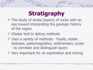
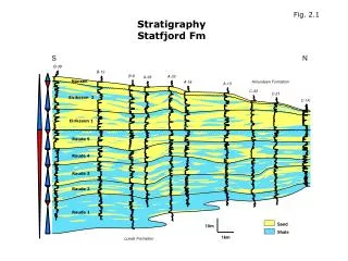
Nansen. Eiriksson 2. Eiriksson 1. Raude 5. Raude 4. Raude 3. Raude 2. Raude 1. Stratigraphy Statfjord Fm. Fig. 2.1. S. N. B-38. B-13. B-8. A-33. A-38. Amundsen Formation. A-18. A-13. C-33. C-21. C-1A. Sand. 10m. Shale. 1km. Lunde Formation. Transgression.

E N D
Nansen Eiriksson 2 Eiriksson 1 Raude 5 Raude 4 Raude 3 Raude 2 Raude 1 StratigraphyStatfjord Fm Fig. 2.1 S N B-38 B-13 B-8 A-33 A-38 Amundsen Formation A-18 A-13 C-33 C-21 C-1A Sand 10m Shale 1km Lunde Formation
Transgression Retrogradation Progradation Fig. 2.2 SOUTH NORTH Nansen Eiriksson 2 Eiriksson 1 Raude 5 Raude 4 Raude 3 Raude 2 Raude 1
Fluvial Channels3D model, Raude Fig. 2.3 sand sand shale shale Raude 1 Raude 5
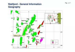
Paleogeography, Cook Fm. Fig. 2.4 StatfjordField StatfjordField
Fig. 2.5 Statfjord Field
Fig. 2.6 Brent Paleogeography Broom Rannoch
Fig. 2.7 Brent Paleogeography Etive (lower part) Etive (upper part)
Fig. 2.8 Brent Paleogeography Ness (lower part) Ness (middle part)
Fig. 2.9 Brent Paleogeography Ness (upper part) Tarbert
Fig. 2.11 Reservoir Zonation Ness Formation sand-shale subdivisions
Ness Sands Fig. 2.12
Fig. 2.13 bay K2, J2 delta (front), bay, fluvial J1 bay, shallow marine I1 bay H2 Tidal & Shallow Marin e fluvial H1 lagoon, bay, shallow marine, tidal G3, G2 bay, tidal bar, lagoon, fluvial, shallow G1 marine lagoon E2 fluvial, lagoon, shallow marine, tidal E1 Lagoon fluvial, shallow marine, lagoon, tidal D1 lagoon, fluvial, shallow marine C2 lagoon, shallow marine, tidal C1 lagoon, shallow marine B2 Fluvial lagoon A3 E1 Sand lagoon, fluvial A2
ETIVE SHORELINE SANDS ETIVE WASHOVERS / BARS Tidal & Shallow Marin e NESS RIVERS NESS LAGOON Lagoon Fluvial E1 Sand Ness (middle part) = C1 -> E2 tid Fig. 2.14
Depositional Environments Ness / Etive Fig. 2.15