Download
1 / 35
380 likes | 441 Views
Get insights into sequence stratigraphy, the study of rock successions in time, using cyclic nature for correlations. Discover parasequences, Walther’s Rule, Milankovich cycles, and basin margin architectures.

E N D
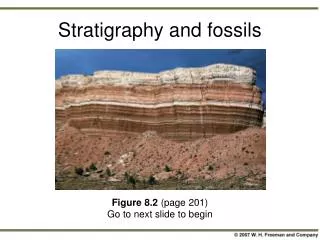
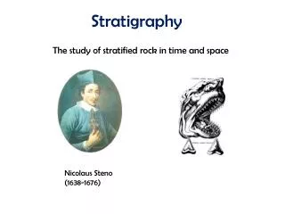
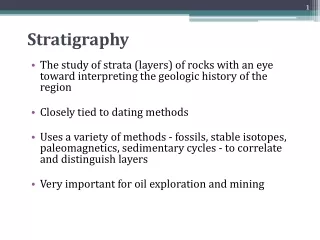
Stratigraphy Stratigraphy is the study of successions of stratified (layered) rocks in time and space. In its classical days, stratigraphy involved simply the study of litho-stratigraphy, that is the succession of rock types in stratigraphic sections. Strata were grouped according to lithologic affinity into the following litho-stratigraphic hierarchy: Supergroup Group Formation Member Bed Formations are the basic building block of litho-stratigraphy, in effect the unit that can be mapped in the field. They are vaguely defined as any unit that can be recognized according to its lithologic character. Over short distances, lithologic formations can commonly be correlated between stratigraphic sections. Distinctive units that occur over wide distances, such as isochronous volcanic ash beds, provide particularly useful correlations.
Correlation Problems Lithologic correlations work well, however, only over relatively short distances. When attempts are made to correlate spatially distant stratigraphic sections, it becomes apparent that lithologic beds are typically diachronous, and lithologic boundaries do not represent constant time lines. There are a number of resolutions to the correlation problem, including biostratigraphy, which uses fossils to correlate between sections, or the recognition of isochronous marker horizons such as bentonite (altered volcanic ash) layers. In recent years, however, attention has focused on sequence stratigraphy, which uses the cyclic nature of stratgraphic successions to correlate between sections.
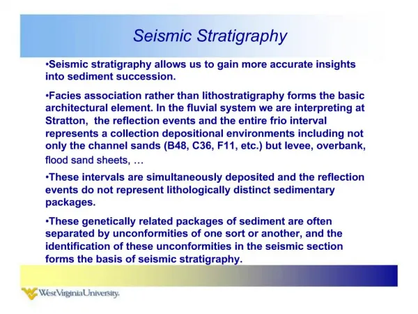
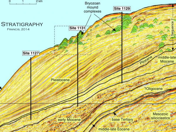
Sequence Stratigraphy Sequence stratigraphy uses the cyclic nature of stratgraphic successions to correlate between sections. The recognition of cycles, and cycles within cycles, has now become quite an art form, and today it is done largely using reflection seismic sections, and is becoming increasingly divorced from direct connection with actual rocks. Individual bands in these images do not correlate to specific rock types, but rather parasequences, thought to represent individual shallowing upward sequences.
Parasequence: The parasequence is the basic unit of sequence stratigraphy. A parasequence is an outcrop scale (meters to 10’s of meters) conformable succession of sedimentary rocks that typically represents a single shallowing upward cycle, bounded by marine flooding surfaces. A parasequence thus represents a single episode of sediment progradation (the seaward movement of shoreline), typically lasting 10’s to 100’s of thousands of years. Lithologic facies within a given parasequence may vary from section to section, and each section need not contain a full range of the lithologies of the shallowing upwards cycle, but the upward succession of lithologies is always the same and strictly obeys Walther’s Rule.
Walther’s Rule of Facies Succession: In a conformable sequence of sedimentary facies, vertically succeeding facies must laterally coexist in time with the facies they succeed. As an example, examine the schematic representation below of an idealized prograding continental margin, comparing what is observed in a single stratigraphic coarsening-upwards sequence, with what is actually happening on a regional scale.
Parasequence Parasequences are terminated by marine flooding events possibly associated with fluctuations in glaciation driven by external Milankovich cycles, but they could also reflect tectonic subsidence or autocyclic processes such as avulsion or simply lobe switching in an active depositional regime. Milankovich cycles: ~100,000 & 400,000 yrs - cycle of orbital eccentricity ~100,000 yrs - cycle of tilt of orbital plane to the ecliptic 41,000 yrs - cycle of tilt of rotation axis 21,000 yrs - chandler wobble of rotation axis
Parasequences occur in “sets” with consistent staking vectors.
Prograding basin margins have a consistent geometric architecture consisting of: • Topsets beds with very low dips (< 0.1o) comprised of relatively shallow water sediments transported by fluvial, tidal, and storm currents, as well as wave action. • Clinoforms beds with steeper dips (> 1.0o) comprised of deeper water facies transported by gravity flows such as debris flows and turbidity currents. The transition between these two is termed the offlap break that is not equivalent to the present continental shelf edge off eastern North America, which is a relict failure, not a depositional feature. The rate of progradation is a balance between sediment supply and the creation of accommodation space: accomodaton space = water depth + deposited sediment = Δ eustasy + Δ tectonic subsidence There are endless arguments about the relative important of eustasy and tectonics in sedimentary basins, which arise from the observation that great thicknesses of sediments appear to have been deposited over time in very shallow water depths and the basic postulate that you cannot sink a rowboat by filling it with sawdust.
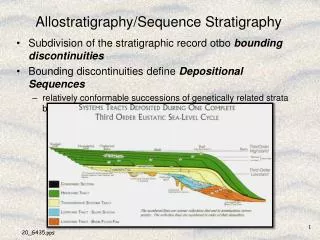
Sequences are stratigraphic successions bounded by surfaces of significant sub-aerial erosion, representing a major cycle of sedimentation lasting from ~ 5 to 15 Mys. They reflect sea level changes in response to major tectonic activity, such as changes in the volume of oceanic ridges and/or sense of sea floor spreading. They are typically comprised of a number of different parasequence sets that can be grouped into one of three “tracts”: low stand tract - sea level below offlap break, down and up transgressive systems tract - topset accommodation vol. > sediment supply maximum flooding surface high stand systems tract - topset accommodation < sediment supply
Sequence Boundary deep water sands and muds - turbidites shallow water carbonate
Role of Tectonic Subsidence now 169 Ma 17 Ma 12 Ma 6 Ma Development of the Queen Charlotte Basin
Sea Level Variations The complete melting of the Antarctic icecap will cause sea level to rise ~ 70 meters; Greenland’s icecap would cause an additional 7 meters of rise. The fact that sea level has been more than 200 meters higher than today requires higher temperatures and shallower ocean basins in the past.
Sea Level Variations Late-Tertiary : 12 Mys Phanerozoic : 500+ Mys sequence boundary
Stratigraphic Records of Climate Change Paleo-temperature variations can be obtained using the stratigraphic variation of oxygen isotopes 16O and 18O. Fractionation of 16O from 18O occurs when water evaporates or condenses, with liquid water always being more 18O-rich than coexisting water vapour. Relatively 16O-rich water vapour migrating from warm equatorial regions towards the colder poles becomes increasingly 16O enriched because of the distillation of 18O into rain. As a result, the polar icecaps are relatively enriched in 16O compared to the oceans. At times of thick ice caps, the oceans are relatively 18O rich because 16O is stored in the ice, while at times of low ice volumes, the oceans are relatively 18O poor because of added 16O from melted ice. Delta 18O = δ18O = ((18O/16O)sample / (18O/16O)standard – 1) × 1000%o
Analyses of the climate variation over the last few 100 thousand years reveals a strong inverse correlation between the concentration of CO2 in the atmosphere, δ18O, and the volume of polar ice. Present CO2 concentration ~ 387 ppm
PETM Marine Methane Clathrate De-Stabilisation? Initial Temperature increase due to CO2 released by the eruption of the Slave Provonce Kimberlite Field? Patterson & Francis, 2013
The Rise of Oxygen global glaciations
The future of Sedimentology : Mars Gale Crater Curiosity
Upper Mound Unit or Formation Aeolian Dust Rock? Boulders
Lower Mound Unit or Formation
Martian Climate Change Lower Mound Unit or Formation