Download
1 / 1
10 likes | 117 Views
This study presents historical trends and initial findings from a comprehensive collation of nitrate databases for surface and groundwater in the karst region of Southeastern Minnesota. By compiling data from the Minnesota Pollution Control Agency (MPCA), U.S. Geological Survey (USGS), and Minnesota Department of Health, the goal is to delineate time trends and understand mechanisms of nitrate pollution. The study includes various monitoring programs and citizen efforts for capturing nitrate data, providing a foundation for understanding and mitigating water quality issues in the region. ###

E N D
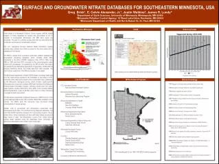
SURFACE AND GROUNDWATER NITRATE DATABASES FOR SOUTHEASTERN MINNESOTA, USA Greg Brick1, E. Calvin Alexander, Jr.1, Justin Watkins2, James R. Lundy3 1Department of Earth Sciences, University of Minnesota, Minneapolis, MN 55455 2Minnesota Pollution Control Agency, 18 Wood Lake Drive, Rochester, MN 55904 3Minnesota Department of Health, 625 North Robert St, St. Paul, MN 55164 Southeastern Minnesota USGS Abstract Historical Trends Initial results of a Minnesota Pollution Control Agency (MPCA) funded collation of nitrate databases for surface and groundwater of the 10 counties of southeastern Minnesota’s (SE MN) karst region are presented. The goal is to identify existing data that can help define time trends and mechanisms of nitrate water pollution. The U.S. Geological Survey’s National Water Information System contains data collected from 1889 to present for the entire nation and is available on the Internet. The MPCA created three successive state-wide ambient (background) groundwater monitoring programs, which includes nitrate data, maintained in the EPA’s STORET database: from 1978 to 1990, from 1992 to 1996, and from 2003 to present. In the current program, urban surface and groundwater are sampled by the MPCA while rural waters are sampled by the Minnesota Department of Agriculture. Another MPCA program, Milestone Rivers, has nitrate data from 1953 onwards. The Garvin Brook watershed of SE MN was studied in more detail. The Minnesota Department of Health (MDH) began recording nitrate data from the initial testing required for the installation of new wells in 1974. Eventually these data will be linked to the County Well Index, maintained by the Minnesota Geological Survey, which includes aquifer-specific information and unique well numbers. MDH also maintains the Minnesota Drinking Water Information System, collecting nitrate data from public water systems. Another MDH effort, since 2008, is the Voluntary Nitrate Monitoring Network, unique to SE MN, which relies on citizen volunteers to sample domestic well waters. The Minnesota Department of Natural Resources’ (DNR) Part B of the County Geologic Atlas series often includes nitrate data, available on the Internet. The DNR’s state fish hatcheries have monitored nitrate concentrations in source springs. Smaller units of government and independent researchers have accumulated much data. The Olmsted County Regional Laboratory has more than 36,000 well-water analyses from surrounding counties. County nitrate clinics, where individuals can have well-water tested, are another large source of data. The Metropolitan Council (Twin Cities) collects surface water samples along the Mississippi River. University of Minnesota dissertations also contain much nitrate data. Web interface for the USGS National Water Information System. Courtesy of Ron Spong. List of Databases MPCA Ambient Programs Nitrate Chronology • 1751Marggraf (Germany) detects nitrate in Berlin water wells. • 1785 Atmospheric nitrogen fixation by Cavendish sparking air. • 1790 Chaptal suggests the name nitrogen. • 1836Boussingault (France) detects nitrate in springwater. • 1887Warington (UK) publishes first time series of nitrate in Rothamsted groundwater. • 1898Crookes (UK) warns of world nitrogen shortage. • 1905 First nitrate analysis for the Mississippi River. • 1906Early use of the term “nitrogen cycle” (OED). • 1911 Nitrate detected in se MN groundwater but called “trace.” • 1913Haber-Bosch fixation of atmospheric nitrogen. • 1938 Agricultural nitrogen pollution not mentioned in USDA Yearbook. • 1944 Norman Borlaug arrives in Mexico to start the Green Revolution— heavy use of nitrate fertilizer. • 1945 Hunter Comly reports Blue Baby syndrome, proposes 10 ppm NO3-N standard. • 1962 US Public Health Service adopts10 ppm standard. • 1960s/1970sGroundwater nitrate rises steeply in the Big Spring Basin of Iowa and elsewhere. • 1970 Anthropogenic nitrogen fixation equal to all terrestrial ecosystems (Delwiche). • 1970s Marine dead zones first observed. • 2005 Anthropogenic nitrogen fixation double that of all natural processes on land combined (Townsend & Howarth). U.S. Geological Survey: National Water Information System Minnesota Pollution Control Agency: Ambient Programs Milestone River Monitoring Program Minnesota Department of Health: MNDWIS New Well Database Voluntary Nitrate Network Minnesota Department of Agriculture: Rural springs & streams Nitrate Clinics Minnesota Department of Natural Resources: County Geologic Atlas, Part B State Fish Hatcheries Minnesota Geological Survey: County Well Index Counties: Olmsted Regional Laboratory Dakota County AGQS Hastings Area Nitrate Study Nitrate clinics Metropolitan Council (Twin Cites): Mississippi River monitoring University of Minnesota (dissertations) Well sampling grid for the 1992-1996 MPCA ambient program. Lanesboro Fish Hatchery Spring