Download
1 / 18
180 likes | 341 Views
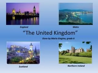
květen 2013 VY_32_INOVACE_AGJ_100102. The United Kingdom geography. Autorem materiálu a všech jeho částí, není-li uvedeno jinak, je Mgr. Olga Klimentová. Střední škola hotelnictví a služeb a Vyšší odborná škola, Opava, příspěvková organizace.

E N D
květen 2013 VY_32_INOVACE_AGJ_100102 The United Kingdomgeography Autorem materiálu a všech jeho částí, není-li uvedeno jinak, je Mgr. Olga Klimentová. Střední škola hotelnictví a služeb a Vyšší odborná škola, Opava, příspěvková organizace. Materiál byl vytvořen v rámci projektu OP VK 1.5 – EU peníze středním školám, registrační číslo CZ.1.07/1.5.00/34.0879.
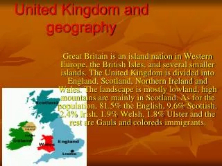
The British Isles • located northwest • of mainland Europe • the North Sea • the Irish Sea • the Atlantic Ocean • the Celtic Sea • the English Channel • (La Manche) • 2 major islands • and more than • 5000 small ones obr. 1
The United Kingdom The British Isles Islands • the Shetland Islands • the Orkney Islands • the Hebride Islands • the Island of Skye • the Isle of Man • Great Britain • Ireland • the Isle of Wight • the Isles of Scilly • the Channel Islands obr. 1
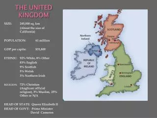
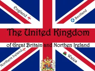
The United Kingdom The United Kingdom geographical and historical parts with their capitals: Scotland – Edinburgh Northern Ireland – Belfast Wales – Cardiff England – London obr. 2
Highland Britain • the Scottish Highlands • the highest peak • Ben Nevis (1,343 m) • in the Grampians • the Pennines • called the backbone • of England • Snowdonia • the highest peak • Snowdon (1,085) • the Cumbrian • mountains obr. 1
Highland Britain Highlands of Scotland Carn Eige and Mam Sodhail obr. 3
Highland Britain Ben Nevis • the highest peak in the Grampians • a part of the Scottish Highlands (1,343 m) obr. 4
Highland Britain Cumbrian Mountains • known as the LakeDistrict • very old rocky mountains • and hilly regions obr. 5
Highland Britain Snowdon (1,085) the highest peak in Snowdonia (just in the cloud on the right) obr. 6
Lowland Britain generally flat with limestone or chalk hills obr. 7
Lowland Britain Cotswolds south-west England chalk cliffs facing the European mainland obr. 8
The United Kingdom Lowland Britain The Strait of Dover the narrowest part of the English Channel view from France over the English Channel to the cliffs of Dover obr. 9 white cliffs form a part of the British coastline (facing towards France– ContinentalEurope)
The United Kingdom The United Kingdom Rivers the Thames (London) the Severn (the longest river) the Trent (Nottingham) the Clyde (Glasgow) the Cam (Cambridge) the Avon (Stratford) the Lagan (Belfast) obr. 10
The United Kingdom The United Kingdom Lakes Loch Ness the most famous lake (a legendary monster called Nessie) Loch Fyne the longest sea loch (65 km inland) Loch Lomond the largest Scottish lake Lake Windermere in the Lake District (the largest of the lakes there) Lough Neagh the largest lake in the UK obr. 11
METODICKÝ POKYN • Jednotlivé snímky prezentace jsou animovány tak, aby se žák mohl do výkladu aktivně zapojit. Nejprve se zobrazí fotografie, po kliknutí pak název dané tematické oblasti, památky či zajímavého místa, a teprve poté se žák postupně seznámí s jednotlivými fakty a doplňujícími informacemi, nejčastěji ve formě stručných odrážek.
POUŽITÁ LITERATURA • KINDERSLEY, Dorling. Velká Británie. Praha: Euromedia Group - Ikar, 2001. ISBN 80-7202-710-7. • LOCKE, Tim, Richard CAVENDISH a Barnaby ROGERSON. Britain: explorer. 2. vydání. Basingstoke: AA Publishing Maps, 1996. ISBN 0-7495-1269-5. • SOMERVILLE, Christopher. Velký průvodce National Geographic: Irsko.Brno: Computer Press, a.s., 2004. ISBN 80-251-1170-9.
CITACE ZDROJŮ • obr. 1: NOTUNCURIOUS. File:Grossbritannien Topographie Jlorenz1 [online]. 2007 [cit. 2013-05-04]. Dostupné pod licencí Creative Commonsz: http://commons.wikimedia.org/wiki/File:Grossbritannien_Topographie_Staedte.jpeg • obr. 2: EDDO. File:Flag-map of the United Kingdom (subdivisions).svg - Wikimedia Commons [online]. 2011 [cit. 2013-05-04]. Dostupné pod licencí Creative Commonsz: http://commons.wikimedia.org/wiki/File:Flag-map_of_the_United_Kingdom_(subdivisions).svg • obr. 3: BARTON, Jim. File:Carn Eige and Mam Sodhail - geograph.org.uk - 1727369.jpg - Wikimedia Commons [online]. 1980 [cit. 2013-05-04]. Dostupné pod licencí Creative Commonsz: http://commons.wikimedia.org/wiki/File:Carn_Eige_and_Mam_Sodhail_-_geograph.org.uk_-_1727369.jpg • obr. 4: BLISCO. File:Ben Nevis south face.jpg - Wikimedia Commons [online]. 2005 [cit. 2013-05-04]. Dostupné pod licencí Creative Commonsz: http://commons.wikimedia.org/wiki/File:Ben_Nevis_south_face.jpg • obr. 5: BIGGLESBEAR. File:Wast Water Lake District.JPG - Wikimedia Commons [online]. 2005[cit. 2013-05-04]. Dostupné pod licencí Creative Commonsz: http://commons.wikimedia.org/wiki/File:Wast_Water_Lake_District.JPG • obr. 6: BLISCO. File:Snowdon-P8060404.JPG - Wikimedia Commons [online]. 2006 [cit. 2013-05-04]. Dostupné pod licencí Creative Commons z: http://commons.wikimedia.org/wiki/File:Snowdon-P8060404.JPG • obr. 7: PARTRIDGE, Steve. File:Kintyre Lowlands. - geograph.org.uk - 555280.jpg - Wikimedia Commons [online]. 2007 [cit. 2013-05-04]. Dostupné pod licencí Creative Commonsz: http://commons.wikimedia.org/wiki/File:Kintyre_Lowlands._-_geograph.org.uk_-_555280.jpg • obr. 8: BEECROFT, Andy. File:Thornwick Bay - geograph.org.uk - 278522.jpg - Wikimedia Commons [online]. 2003 [cit. 2013-05-04]. Dostupné pod licencí Creative Commonsz: http://commons.wikimedia.org/wiki/File:Thornwick_Bay_-_geograph.org.uk_-_278522.jpg
CITACE ZDROJŮ • obr. 9: SÜSSBRICH, Rolf. File:FranceGrisNez2Dover.jpg - Wikimedia Commons [online]. 2010[cit. 2013-05-04]. Dostupné pod licencí Creative Commonsz: http://commons.wikimedia.org/wiki/File:FranceGrisNez2Dover.jpg • obr. 10: NOTUNCURIOUS. File:Major.rivers.of.England.jpg - Wikimedia Commons [online]. 2010[cit. 2013-05-04]. Dostupné pod licencí Creative Commonsz: http://commons.wikimedia.org/wiki/File:Major.rivers.of.England.jpg • obr. 11: ALEXRK2. File:United Kingdom relief location map.jpg - Wikimedia Commons [online]. 2012[cit. 2013-05-04]. Dostupné pod licencí Creative Commonsz: http://commons.wikimedia.org/wiki/File:United_Kingdom_relief_location_map.jpg