Download
1 / 19
200 likes | 369 Views
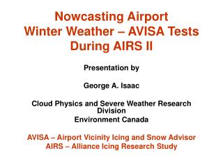
Nowcasting Airport Winter Weather – AVISA Tests During AIRS II. Presentation by George A. Isaac Cloud Physics and Severe Weather Research Division Environment Canada AVISA – Airport Vicinity Icing and Snow Advisor AIRS – Alliance Icing Research Study. Co-Authors & Funding Agencies.

E N D
Nowcasting Airport Winter Weather – AVISA Tests During AIRS II Presentation by George A. Isaac Cloud Physics and Severe Weather Research Division Environment Canada AVISA – Airport Vicinity Icing and Snow Advisor AIRS – Alliance Icing Research Study
Co-Authors & Funding Agencies • Monika Bailey, Stewart Cober, Norman Donaldson, Ismail Gultepe, Norbert Driedger, David Hudak, Anna Glazer, Janti Reid, Peter Rodriguez, and J. Walter StrappEnvironment Canada, Toronto • Alexei Korolev Skytech Research Inc, Richmond Hill • Frederic FabryMcGill University, Montreal • Funds from Transport Canada, FAA, SAR/NIF, NRC/IAR, CRC, McGill, CFCAS, NSERC
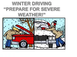
Problems Associated with Airport Winter Weather • Ice forming on wings of aircraft requiring de-icing • Reduced visibility • Low ceilings • Runway icing and snow removal • In-flight icing during takeoff and landing • Extreme cold temperatures
Hazardous Hours at Canadian Airports Stuart and Isaac, 1994: ICAO Journal
Alliance Icing Research Study II • A large international research program (participants from 25 organizations from N.A. and Europe, gov’t and university sectors) • Lead by MSC • Conducted in the Ottawa-Mirabel region 3 Nov 2003 to 13 Feb 2004 • Focus on aviation meteorology research, nowcasting, aircraft icing, cloud processes • Web site http://airs-icing.org/ (Science Plan, Data access, publications, etc) • Endorsed by Aircraft Icing Research Alliance (AIRA) and WWRP Aircraft In-Flight Icing Project (AIFI) • Five (5) research aircraft involved • Three (3) different Nowcasting systems (MSC, NASA, NCAR/NOAA) • Data currently being quality controlled and archived • Project Workshop was conducted at Mt. Tremblant, 9-10 November • Special Session at AIAA in Reno in January/05
AIRS II Precipitation & Flight Summary over Mirabel IOP1 IOP2
Radiometers HIMAP & GEM Models AVISA Input Parameters POSS, HP & Met Station GOES Satellite Vertically Pointing Radar (VPR)
ARE SKIES CLEAR? YES SLW IS ASSUMED FALSE FOR ALL HEIGHTS NO Supercooled Liquid Water (SLW) METHOD 1 DERIVE BEST GUESS CTH DERIVE BEST GUESS CBH YES IS THERE LIQUID PRECIPITATION? SLW IS INCONCLUSIVE FOR HEIGHTS BETWEEN BEST GUESS CT & CB NO IS THE RADIOMETER LWP > 0C AND GEM MODEL TEMP < 0C? NO SLW IS ASSUMED FALSE AT THAT HEIGHT YES SLW IS ASSUMED TRUE FOR THAT HEIGHT
Temperature [deg C] Altitude [km] LWC [g/m3] or [g/kg] for HIMAP LWC [g/m3] and Sphere Particle Fraction Case Study: February 6, 2004 1900-2210 UTC M+S Icing
HIMAP Total Precipitation Rate and Radar HIMAP Total Precipitation Rate and Radar HIMAP Supercooled LWP & GOES Icing 0.9 mm/hr 0.9 mm/hr 0.03 cm 0.03 cm 0.5 mm/hr 0.5 mm/hr YMX > 0.5 mm/hr > 0.5 mm/hr 0.04 cm 20 km 20 km GOES ICING @ 1902 February 6, 2004 - 19 UTC in the vicinity of YMX HIMAP Supercooled LWP & GOES Icing 0.03 cm 0.03 cm YMX YMX 0.04 cm GOES ICING @ 1902 LWP Observations & Forecast at YMX Precipitation Observations & Forecast at YMX
Liquid Water Paths Water Vapour Paths HIMAP LWP [cm] HIMAP WVP [cm] Profiling Radiometer LWP [cm] Profiling Radiometer WVP [cm] Model/Radiometer Comparison
November 4-5, 2003: Freezing Rain Event Orange marks when the YMX observerreported ZR Time series data contain a change in model runs at 00 Z POSS reports mainly rain type Wx
Conclusions • AIRS II produced an excellent data set to develop and test airport systems to detect winter weather, with emphasis on icing and snow. • Although weaknesses in some sensors and models were documented, a good system will use the strengths from various potential input components to produce reliable and accurate detection and forecast methods. • Other aspects such as SLD formation, aircraft response to icing, and cloud characterization measurements also studied but not reported here.
GLFE (Great Lakes Fleet Experiment) is a 12-month project started in Jan 2005 that is testing tropospheric AMDAR systems aboard 64 aircraft in the Great Lakes region TAMDARs also measure RH, icing and turbulence Graph shows TAMDAR icing and temperature data collected in the vicinity of Pearson on Aug 31 2005 TAMDAR Data