Topographic Maps
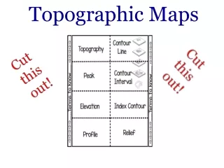
Topographic Maps. Important Terms Topography depression Contour line benchmark Contour interval Topography Topography means “ the __________ of the land”. Topographic maps show changes in elevation of the earth’s surface.

Topographic Maps
E N D
Presentation Transcript
Topographic Maps • Important Terms • Topography depression • Contour line benchmark • Contour interval • Topography • Topography means “ the __________ of the land”. • Topographic maps show changes in elevation of the earth’s surface. • They take 3 dimensional landforms and place them on a ___________ map. • Topographic maps show scale, width, length and height of the land above and below sea level. • Contour line • A line drawn on a topo map that connects all points that have ____________ elevation • Contour Lines follow certain rules • Every point on a contour line is the same elevation • Contour lines never cross or divide(split) • Widely spread con tour lines mean ________ slope • ___________ spread contour lines mean steep slope • __________ are shown in concentric closed contours • A contour line forms a “V” pointing __________(uphill) when crossing a river or stream. • Closed depressions on the land are shown with closed contours with hachure (_________) that point down slope • Contour Interval • The contour interval is the __________ in elevation between any two adjacent contour lines • Contour Interval • The contour interval is the __________ in elevation between any two adjacent contour lines • Contour lines are drawn in ________ of the contour interval. If the interval is 10 feet, then the elevations are marked every ______ feet. • Index contours • Index contours are ________ lines with the elevation marked on them. They occur every _______ contour lines • Benchmarks • Reference points of ________ elevation. They are marked on the earth’s surface with a round metal disk. • Topographic profiles • A topographic profile is used to change an overhead view on a topographic map to a profile (side) view. • How to construct a topographic profile • On the contour map, draw a line between two points along which the profile will be constructed. • Lay a sheet of paper along the line. Mark each place whew a contour line intersects the edge on the paper and write the elevation of the contour line by each mark • On a separate piece of paper draw a horizontal line slightly longer than the profile line • Draw a scale along the edge of the paper that corresponds to the contour intervals found in the profile. The starting elevation should be lower than the lowest elevation on the profile and higher that the highest elevation on the profile • Lay the marked edge of the other paper along the horizontal line. Place a dot on the vertical scale equal in elevation directly above each mark along the paper edge • Connect the dots to see the profile.
Map Reading Activity: Topography1. Color the elevations on the topographic map as follows. Red: 50m and higher, Orange: 40-50m, Yellow: 30-40m, Light green: 20-30m, Dark green: 10-20m, Purple: 0-10m. 2. Approximately how tall is Able Hill? ___________________________ 3. Approximately how tall is Baker Hill? ___________________________ 4. Which mountain is taller, and by about how much? ___________________________ 5. How many meters of elevation are there between contour lines on the topographic map? ___________________________ 6. Which mountain has steeper slopes? ___________________________ 7. Are the contour lines closer together on Able Hill or Baker Hill? ____
Contour Maps • How to recognize landform on a topographic map • Hill • Valley • Stream • Depression • Cliff • Steep slope • Gentle slope