Settlement Site and Settlement Situation
230 likes | 1.13k Views
Settlement Site Factors. Wet point site Where a settlement is near to a water supply.Dry point site Where a settlement is located in an area that will remain dry.Defence A settlement that was set up to make it easy to see your enemies coming.Bridging point A settlement located where a riv

Settlement Site and Settlement Situation
E N D
Presentation Transcript
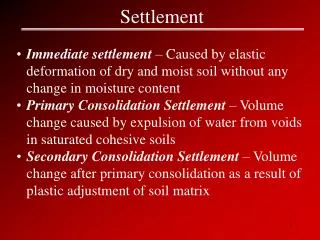
1. Settlement Site and Settlement Situation Settlement site is exactly where the settlement is located.
Settlement situation is what the area around the settlement is like.
2. Settlement Site Factors Wet point site � Where a settlement is near to a water supply.
Dry point site � Where a settlement is located in an area that will remain dry.
Defence � A settlement that was set up to make it easy to see your enemies coming.
Bridging point � A settlement located where a river or stream is bridged.
Resources � A settlement that is near to a food supply and other building materials.
Communications � Settlements often grew at bridging points, around a crossroads or gaps between hills.
3. Settlement Site Factors Today The majority of settlement site factors mean nothing today.
You no longer have to be near a water supply for example. You can bring nearly everything you need to the settlement.
An example of this is Las Vegas in the USA. Las Vegas is in the middle of a desert.
4. Settlement Hierarchy A settlement hierarchy arranges settlements in order of importance.
The higher up the hierarchy the bigger the settlement, the more services it has and the more urban it is.
5. Sphere of Influence The sphere of influence is the area served by a settlement. It is sometimes called the Catchment area or Hinterland.
Threshold Population � The smallest number of people a shop needs to make money.
Range of good � The largest distance people are prepared to travel to buy something.
6. Settlement Function The function of a settlement is its purpose, why its there.
Many large towns or cities are multi-functional, have more than one.
Functions of settlements change over time.
They change as residential zones grow, industry shuts down.
Most settlements started out with farming as their function and as the population grew the function changed to industry.
Settlement functions are Fishing, Mining, Quarrying, Engineering, Transport, Port and Holiday.
7. Settlement Shape Settlements usually develop in a particular pattern (but not always).
A nucleated settlement is where the buildings are clustered around a central point, e.g. a bridge or market square � E.g. Eastenders
A linear settlement is where the buildings are arranged in a line - usually along a river or road � E.g. Coronation Street
A dispersed settlement � E.g. Emmerdale
8. Urbanisation Urbanisation is the process of urban growth.
Urbanisation happens when people migrate from rural areas.
It causes problems such as traffic congestion, shanty towns may grow and rural areas can get worse.
It has benefits too � Improved services, boosts economy and can provide jobs.
9. Millionaire Cities These are cities with over 1 million people in them. E.g. Tokyo, Sao Paulo and London.
Most of these cities were located in the Northern Hemisphere and were MEDC�s
Today most are in the Southern Hemisphere and are LEDC�s.
This change has happened because most LEDC�s have poor access to contraception, need large numbers of workers in informal work sectors and population growth in MEDC�s has slowed down.
10. Urban Shape � Burgess� Model
11. Urban Shape � Hoyt�s Sector Model
12. What is the city like? The city can be split into four zones, the CBD, Inner � City, Suburbs and the Rural Urban Fringe.
CBD � Some housing, often refurbished flats.
Inner � City � High � rise flats and modern executive apartments and terraced housing often built in grid shapes.
Suburbs � Mostly semi-detached housing built in estates.
Rural Urban Fringe � Mostly detached housing, sometimes built in estates, very expensive.
13. Brownfield/Greenfield Sites Brownfield sites are old industrial sites that are no longer in use. They tend to be polluted and need cleaning up before development.
Greenfield sites are undeveloped areas that are usually outside of the city, sometimes on the Urban/Rual Fringe.
14. The Central Business District or CBD The CBD is the heart of the city where many of the shops and offices are to be found.
CBD�s change a lot over time.
Gloucester has seen many changes.
Pedestrainised streets, Europe's largest shopping centre, Docks decline and regeneration, the possible Donut effect due to shopping centre.
15. How the government is controlling Urban Growth - Green Belts Green Belts are areas of open land around cities where building is banned.
They were created to stop urban sprawl.
Urban sprawl is the uncontrolled growth of cities.
They were also created to stop the creation of Connurbations, which is when two settlements join together.
There is a Greenbelt around Gloucester
The government also control the town planning of a city.
16. Urban Problems in MEDC�s Pollution
Disease e.g. Asthma
Traffic Congestion
Crime
Urban/Inner city decline
Donut effect
17. Solving Urban Problems in MEDC�s Congestion charges
Car share schemes
Regeneration of old run down industrial areas. E.g. Gloucester Docks
Urban regeneration e.g. Glasgow
Use of voluntary police officers to reduce crime.
18. Urban Problems in LEDC�s Crime
Pollution
Traffic congestion
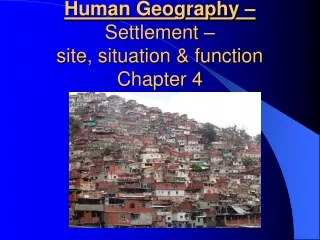
Shanty Towns
Disease e.g. Cholera
Unemployment
19. Glasgow Case Study Glasgow is located in Scotland
It had many urban problems.
In the 1950�s a programme of urban renewal and regeneration began.
Comprehensive Development Areas were identified and the old terraced tenemant buildings were knocked down.
In their place high rise flats were built.
These high rise flats were a mistake and made things worse as they encourage crime and created a dead heart.
The Govan Initiative created start up units for business�, landscaped local areas and reopened a ship yard.
The final idea was to refurbish the flats turning them into Japanese style Pagoda�s.
20. Sao Paulo Case Study Sao Paulo is in Brazil
It has a very large Favela or shanty town
Government is trying to solve the problem of the Shanty Town by-
Building Brasilia to stop people going there.
Improving transport networks to help create jobs
Improving the rural areas to reduce migration to urban areas
Self help schemes � giving people building materials
Improving sanitation