Download
1 / 21
210 likes | 356 Views
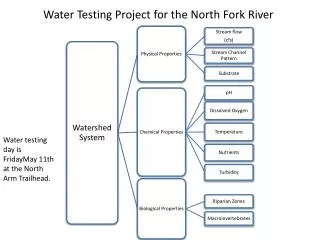
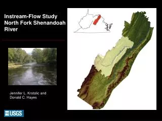
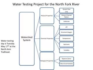
Water Testing Project for the North Fork River. Water testing day is Tuesday May 17 th at the North Arm Trailhead. Physical Properties of a Watershed System. Stream Shape. Stream Flow. Stream Flow. The amount of water that flows past a specific point in a stream over a period of time.

E N D
Water Testing Project for the North Fork River Water testing day is Tuesday May 17th at the North Arm Trailhead.
Physical Properties of a Watershed System Stream Shape Stream Flow
Stream Flow The amount of water that flows past a specific point in a stream over a period of time.
Natural Influences that affect Stream Flow • Climate • Season • Watershed • Meandering • Substrate • Groundwater • Vegetation
Human influences affecting stream flow Dams Channelization Land use
Why do we care about Stream Flow? • Water quality : affects turbidity (sediment load) and • dissolved oxygen • Aquatic life : creates different habitats for fish and bugs • Vegetation: needs overbank flooding for nutrients • Flooding: controlled for human structures • Water storage: determines how and when water • should be stored
Method to measure & calculate stream flow 1. Measure a 10 m section and mark it with rocks. 2. Throw a stick in above this section and use a stop watch to measure the time it takes the stick to travel the 10 m section 3 separate times. Average the times. 3. Divide the average time (sec) by the distance (10m) to get the velocity (m/s). 4. Measure the depth (m) & width(m) to find an area (m2). 5. Stream flow = velocity (m/sec) x area (m2)
What influences stream shape? • Substrate Type • Stream Channel Pattern • Riffle/ Run /Pool Ratio
Substrate Types Silt Cobble Sand Boulders Bedrock Gravel
Method for Recording observations of substrate • Step into the stream, without looking bend down and pick up some sediment. • Tell your partner the type of substrate you are holding, have them record the type with a tally mark. • Take 50 samples in and along the river section. • Tally your total number of observations for each type of substrate. • Multiply the number of observations of each type by 2. This will equal the % out of 100 for each substrate.
Top View of Stream Stream Channel Patterns Cross-section view meandering straight braided
Meandering Stream Found in valley bottoms without much slope. Slower Velocity. Big pools, some riffles and runs Mixture of sand bars & suspended silt particles.
Straight Stream Steep gradient, fast flowing Substrate is predominantly cobble and gravel Mostly runs some riffles
Braided Stream River continually splits and rejoins. River moves across broad flat plains. Slow and fast velocities. Mostly runs and riffles. Mixture of silt, Sand, and gravel.
Habitat areas of a Stream Channel Run Run run
Riffles have high oxygen amounts essential for macroinvertabrates (bugs) and spawning fish. Runs where fish feed and travel Pools where fish hide and rest from the current
Method for Recording Riffle Run Pool Ratios 1. Take one step next to your river section, look across the river. • Record a tally mark on your sheet that shows if you see a river, run, or pool 3. Make 50 observations. 4. Total the tally for each characteristic. 5. Multiply the totals by 2 to find the % riffle, run or pool that your river section contains.
Natural Influences affecting Stream Shape Friction created by substrate Velocity Vegetation
Human Influences affecting Stream Shape Development, logging, mining, grazing can destroy vegetation which causes more water and sediment to drain directly into a stream rather than being filter through groundwater. Channel alterations, ie. straightening of a stream along a highway or through a city center Dams prevent downstream flooding but then stream nutrients are not distributed throughout the floodplain to plants.
Why do we care about stream shape? • Stream shape affects water quality Straightening of a stream increases velocity, which results in higher erosion rates and more turbidity Darker streams impact temperature and amount of sunlight that reaches plant life. • Stream shape affects habitat. A straight stream does not have the variety of habitats found in a meandering stream • Stream shape impacts flooding
How will you interpret your results? Physical Characteristics of the river will be correlated to the chemical and biological parameters. Some Examples: Channel pattern and shape will effect velocity and erosion which will in turn effect temperature and oxygen and/or nutrients. Substrate will be related to velocity and oxygen which will determine how many bugs are in the river. Riffle/Run/Pool ratio will indicate the diversity of the aquatic habitats and in relation to this the diversity of life in the stream. High diversity correlates to high water quality.