Download

1 / 14
140 likes | 243 Views
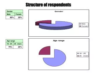
Parcel Survey Respondents - All. 67 Reponses http://batchgeo.com/map/29d8ca37c5d17e5dc702079872c91a57 56 in-state 11 out of state IP Based. Respondent Breakdown. 24 - State Government 8 - Federal Government 13 - Local Government 18 - Private Business 4 - Other 67 Total Repondents.

E N D
Parcel Survey Respondents - All • 67 Reponses • http://batchgeo.com/map/29d8ca37c5d17e5dc702079872c91a57 • 56 in-state • 11 out of state • IP Based
Respondent Breakdown • 24 - State Government • 8 - Federal Government • 13 - Local Government • 18 - Private Business • 4 - Other • 67 Total Repondents
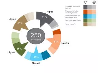
Respondent Profession • 67% of Respondents work in: • Information Technology (GIS) • Water Resource Planning • Natural Resource Mngt • Engineering and Construction • Planning / Zoning
Acquisition of Parcel Data • 57% of respondents get parcel data for free. • 27% have paid between 1k and 10k for parcel data • Private Sector • 15% of respondents are unsure about parcel dataset costs. • Bill SB400 Effective July 1st 2011, county parcel data requests by the State Demographer must be fulfilled free of charge. State agencies may request parcel data free of charge from State Demographer, if state agency is engaged in activities related to economic development or population estimate research .
Local Government Representation • Washoe County (3) • Eureka County(1) • Churchill County (1) • City of Henderson (2) • Clark County + Las Vegas (4) • Carson City and 3 Neighboring Counties (1)
Local Gov Parcel Sources and Cost • 77% Generate or share data parcel data locally (Q9 + Q16) and are happy with the sharing situation locally(Q19) • Data sharing is common locally • Interlocal Agreements Common - $8k per member • Basemap Committee, Washoe have a membership fee • Counties still charge consultants by section or county • Some localities make data freely available to government or non-profits • Maintenance costs are high for local agencies • (10,000 – 1 million) • Full-time employee’s responsibility
Future Parcel Impressions • A standardized parcel product is desired by 61.5% of respondents (Q13) • More that 50% are unsure or do not desire online parcel services over getting parcel data directly (Q14) • Future Parcel Data Acquisition Planning Unclear (Q15) • But respondents are interested or need more information about cost-sharing programs (Q20)
State Audience Breakdown • 5 - State of Nevada • 6 - Dept. of Transportation • 2 - Dept. of Conservation and Natural Resources • 3 - Division of Water Resources • 1 - Division of Forestry • 2 - Nevada DEP • 1 - Dept. of Wildlife • 1 - Nevada Bureau of Mines • 2 – California Interests • Planning and Conservancy
Department Representation in State Audience • 7 - Water Resources • 6 - IT (GIS) • 5 - Natural Resources • 4 - Engineering and Construction • 3 - Planning and Zoning • 3 - Administration
State Representative - Parcel Feedback • Locating Good State Parcel Data is a Challenge due to varying management • Parcel data is free for certain state projects (SB400) • State respondents are not maintaining parcel datasets • A standardized parcel data product is highly desired by state respondents • There is no state respondent consensus on the creation of an online parcel resource. • State experiences sharing data with local agencies vary greatly pre and post 7/1/2011 • State respondents do not share parcel dataset and are undecided on how a cost-sharing arrangement would benefit state organizations. • State respondents are currently evaluating the application of SB400. • State respondents are interested in being kept in the loop about parcel management developments.
Private Sector Representation • 6 - GIS / IT • 3 - Natural Resource Mngt • 2 – Engineering - Construction • 3 - Planning • 1 - Consulting • 3 - Other
Private Sector Feedback • Varied spatial focus: neighborhood to multi-state projects • Barriers to Data Use • 53.8% cannot afford the data • 38.5% complain the data doesn’t exist or is to inaccurate or outdated • 40% pay between 1k and 10k for data • 89% will continue to need data in the future
Private Sector Feedback • Large concerns about data accuracy and how current the data is. • Free access to data while under city of county contract is the desire of private companies.