Download
1 / 39
390 likes | 411 Views
This study investigates the impact of wildfires on the hydrologic response of watersheds in Southeast Arizona, specifically focusing on the magnitude and frequency of flash floods. It also explores the need for tools that can quickly estimate peak flow and flood potential from burned areas. The study documents the hydrologic recovery period after wildfires and provides empirical formulas to estimate peak discharge for up to 10 years post-burn.

E N D
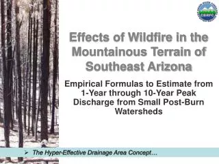
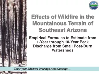
Effects of Wildfire in the Mountainous Terrain of Southeast Arizona Empirical Formulas to Estimate from 1-Year through 10-Year Peak Discharge from Small Post-Burn Watersheds • The Hyper-Effective Drainage Area Concept…
WHY • Southeast Arizona has recently been impacted by several wildfires. • In the desert southwest of the United States, wildfire alters the hydrologic response of watersheds greatly increasing the magnitudes and frequency of flash floods. • The NOAA National Weather Service is tasked with the issuance of flash flood warnings to save life and property. • Tools that allow the weather forecast offices to quickly access the peak flow magnitude and flood potential from burned areas is highly desirable. • Hydrologic recovery to near pre-burn conditions takes 3 to 5 years…
WHY • Southeast Arizona has recently been impacted by several wildfires. • In the desert southwest of the United States, wildfire alters the hydrologic response of watersheds greatly increasing the magnitudes and frequency of flash floods. • The NOAA National Weather Service is tasked with the issuance of flash flood warnings to save life and property. • Tools that allow the weather forecast offices to quickly access the peak flow magnitude and flood potential from burned areas is highly desirable. • Hydrologic recovery to near pre-burn conditions takes 3 to 5 years…
WHY • Southeast Arizona has recently been impacted by several wildfires. • In the desert southwest of the United States, wildfire alters the hydrologic response of watersheds greatly increasing the magnitudes and frequency of flash floods. • The NOAA National Weather Service is tasked with the issuance of flash flood warnings to save life and property. • Tools that allow the weather forecast offices to quickly access the peak flow magnitude and flood potential from burned areas is highly desirable. • Hydrologic recovery to near pre-burn conditions takes 3 to 5 years…
WHY • Southeast Arizona has recently been impacted by several wildfires. • In the desert southwest of the United States, wildfire alters the hydrologic response of watersheds greatly increasing the magnitudes and frequency of flash floods. • The NOAA National Weather Service is tasked with the issuance of flash flood warnings to save life and property. • Tools that allow the weather forecast offices to quickly access the peak flow magnitude and flood potential from burned areas is highly desirable. • Hydrologic recovery to near pre-burn conditions takes 3 to 5 years…
HOW Hydrologic response within the first two years after the occurrence of wildfire of ten watersheds in Southeast Arizona documented: Frye Canyon (USGS gage) Deadman Canyon (private consultant) Marijilda Canyon (USGS & NWS) Noon Creek (Schaffner & Reed) Wet Canyon (Schaffner & Reed) Upper Campo Bonito (USGS) Sabino Creek near Mount Lemmon (Pima Co. gage) Alder Canyon at Ventana Windmill (Schaffner & Reed) Madera Canyon (Schaffner & Reed) Romero Canyon(AZ Geological Survey) • Indirect measurement of peak flows…
Santa Catalina, Santa Rita, and Pinaleno Mountains in Southeast Arizona…
DATA REQUIREMENTSSpecifications • short-term thunderstorm with a duration approximately equal to or greater than the time of concentration for the burned basin at outlet • return interval of rainfall equal to or less than the 10-year return interval • storm core to have moved over at least a portion of the hyper-effective drainage area • documented flood was “first major flush” since watershed burned • burn occurred in mountainous terrain • small total basin size (less than 15 square miles) • uncontrolled basin (no dams or other hydraulic structures) • Flood occurred… Upper Campo Bonito
Steps for Calculating 5-Year Post-Burn Flows • calculate the basin average precipitation for events known to have caused floods from the burned basins (an attempt was made to use the first major flush after a burn) and document storm duration, • determine the return period of these rain events, • determine the peak flow of the flood event, • calculate the pre-burn peak flow for the corresponding return period of the precipitation event, • calculate the pre-burn 5-year peak flow, • calculate the ratio of pre-burn peak flow to post-burn peak flow1 and • multiply the pre-burn 5-year peak flow for a basin (determined in step 5) by the corresponding ratio (determined in step 6). 1This ratio is calculated by dividing the result of step 3 by the result of step 4 and is basin specific…
[1] Above Crippen and Bue (1977) value of 23,700. [2] Above Crippen and Bue (1977) value of 13,500. These y values are referred to as target values.
[1] Above Crippen and Bue (1977) value of 23,700. [2] Above Crippen and Bue (1977) value of 13,500.
Prepared by William B. Reed • Post-Burn Response up to 207 times greater than Pre-Burn…
MULTIVATIATE RUNOFF INDEX(mvi) • Variables: • Hyper-Effective Drainage Area (determined from burn severity) • Average Basin Elevation • Objective Southeast Arizona Specific — Modified Channel Relief Ratio • Return Interval of the Forecasted Rainfall Event • Basin and storm properties chosen after several tries… Noon Creek
hyper-effective drainage area • is the area of the high severity burn plus the area of the moderate severity burn (variable in square miles) • the remaining drainage area is not used in the calculations • therefore, the results of the post-burn envelope curve and a pre-burn equation should be compared and the higher result used • If in doubt, compare results with standard equations…
modified channel relief ratio • is the average slope of the basin along the first order channel measured from 1,250 feet (381 meters) below the ridge to the basin outlet ---(variable in feet/feet) Marijilda Canyon • Excludes reach without channels ~ Includes reach at outlet…
mvi • two types of equations • Fixed Flow Return Interval • Rainfall Return Interval a Variable and Flow Return Interval Not Assigned Alpha Psi Beta Phi Lambda
Fixed Flow Return Interval • Post-Burn 2-Year Flood (97%)* • Post-Burn 5-Year Flood (67%)* • Post-Burn 10-Year Flood (41%)* *Chance of one or more events in 5 years • Hydrologic recovery to near pre-burn conditions takes 3 to 5 years…
Prepared by William B. Reed • Ten data points (2-year target values)…
An Empirical 5-Year Post-Burn Runoff Equation for Southeast Arizona Watersheds 16000 Envelope Curve 0.653 y = 4113.6x 14000 12000 10000 Peak Flow (cfs) Best Fit Equation 8000 2 R = 0.96 adj Cross Validation Standard Error = 1757 cfs Cross Validation Adjusted Correlation Coefficient = 0.90 6000 2 Cross Validation R = 0.81 adj predictive equation: peak flow = 1993 times multivariate runoff index 4000 2nd year 1.0035 y = 1993.4x 2 R = 0.9747 2000 Prepared by William B. Reed 0 0 0.5 1 1.5 2 2.5 3 3.5 4 4.5 5 5.5 6 6.5 7 7.5 Multivariate Runoff Index • Ten data points (5-year target values)…
Prepared by William B. Reed • Ten data points (10-year target values)…
Fixed Flow Return IntervalConcerns • Developed by Assuming T-Year of Rainfall was equal to T-Year of Flow • Same Basin Specific Ratio Used for 2-Year, 5-Year, and 10-Year Flow Return Intervals • Not bad assumptions given the properties of the data set…
Flow Return Interval Not Assigned • Rainfall Return Interval a Variable…
? Prepared by William B. Reed Envelope Curve Defined to be Above Target Values Assuming T-Year of Flow is Equal to T-Year of Rainfall. Ten data points where Best Fit Curve is independent of target values….
This Envelope Curve is Equation 10. Looks better but is it? Prepared by William B. Reed • 40 data points includes 30 target values…
Question Can T-Year Equation and Return Interval Equations be Unified? • Duration of storm equal to or greater than time of concentration…
Paradigm Shift • Target Values Evaluated • Results Consistent with Expectations • Modified Values Used • Assuming t-year best fit equation is correct…
Modified Target Values Envelope Curve • 2-year unique target values were increased by 22%, • 5-year values were unchanged, and • 10-year unique target values were decreased by 38%. Preliminary Results = post-burn runoff for the t-year return intervals between 1 and 10 years (cfs) (mvi6) =
This Envelope Curve is Equation 12. Preliminary Results Prepared by William B. Reed • 34 data points includes 24 modified target values…
Preliminary Results Return interval increasing
Conclusions • The use of Hyper-Effective Drainage Area Concept has been demonstrated. • Two types of equations for Post-Burn Flows have been developed: • Fixed Flow Return Interval (2-Year, 5-Year, and 10-Year Equations) • Rainfall Return Interval a Variable and Flow Return Interval Not Assigned. • These equations provide similar results. • Use of modified target values recommended…
Acknowledgments • Chris Smith, Dan Evans, and Saeid Tadayonof the U.S. Geological Survey • Barry Scottof Arizona Division of Emergency Management • Robert Lefevreof U.S. Forest Service • Ann Youbergof the Arizona Geological Survey • Mike Schaffner, Ed Clark, Kevin Werner and Erik Pytlakof NOAA National Weather Service Madera Canyon
Selected References • Crippen, J. and C. Bue, 1977. Maximum Flood flows in the Conterminous United States. USGS Water Supply Paper 1887. • Reed, W. and M. Schaffner, 2007. Effects of Wildfire in the Mountainous Terrain of Southeast Arizona: An Empirical Formula to Estimate 5-Year Peak Discharge from Small Post-Burn Watersheds. NOAA Technical Memorandum NWS WR-279. Available online: http://www.wrh.noaa.gov/wrh/techMemos/TM-279.pdf. • Reed, W. and M. Schaffner, in review. Effects of Wildfire in the Mountainous Terrain of Southeast Arizona: Empirical Formulas to Estimate from 1-Year through 10-Year Peak Discharge from Small Post-Burn Watersheds. • Schaffner, M. and W. Reed, 2005a. Effects of Wildfire in the Mountainous Terrain of Southeast Arizona: Post-Burn Hydrologic Response of Nine Watersheds. NOAA National Weather Service Western Region Technical Attachment 05-01. Available online: http://www.wrh.noaa.gov/wrh/05TAs/ta0501.pdf. • Schaffner, M. and W. Reed, 2005b. Evaluation of Post-Burn Hydrologic Recovery of a Small Mountainous Watershed: Upper Campo Bonito Wash in Southern Arizona. NOAA National Weather Service Western Region Technical Attachment 05-06. Available online: http://www.wrh.noaa.gov/wrh/05TAs/ta0506.pdf. • Thomas, B., et. al., 1997. Methods for Estimating Magnitude and Frequency of Floods in the Southwestern United States. USGS Water-Supply Paper 2433. Available online: http://pubs.er.usgs.gov/pubs/wsp/wsp2433#viewdoc.
Thank You. Bill.Reed@noaa.gov Basin Conditions River Forecasts Water Supply