Download
1 / 14
140 likes | 315 Views
ON THE CALCULATION OF MAXIMAL OUTLETS OF SMALL MOUNTAINOUS RIVERS (in Armenian conditions). Boris Mnatcakanyan, Kamo Aghababyan, Levon Chilingaryan Institute of Water Problems and Hydrotechnics Yerevan, Armenia E-mail: Kaghabab@aua.am. Abstract:

E N D
ON THE CALCULATION OF MAXIMAL OUTLETS OF SMALL MOUNTAINOUS RIVERS(in Armenian conditions) Boris Mnatcakanyan, Kamo Aghababyan, Levon Chilingaryan Institute of Water Problems and Hydrotechnics Yerevan, Armenia E-mail: Kaghabab@aua.am
Abstract: In mountainous countries with complex physical geographical conditions, such as the territory of the Republic of Armenia, the calculation of the maximal outlets of small rivers has a very important practical meaning, since these rivers bring mudflows and cause serious damage to many branches of economy. The methods used to evaluate the maximal outlets are often not accurate enough. We have carried out a comparative research of the case study of the Marmarik river with application of a number of methods used in Soviet times and methods used abroad. The research shows that when calculating the maximal outlets of small rivers it is more efficient to use the formulae or the maps, so far as the values calculated with the use of these formulae and maps are close to the maximal outlets values defined by the rivers with long series of measurements.
For determination of the maximal flow parameters at present in Armenia the former Soviet Union norms are used. However these norms are not used in every complicate physical geographical Armenian conditions, particularly, in hydrologicaly uninvestigated mountain rivers and the acting waterfalls. For the last methodological indications and recommendations, taking into account local conditions of floworganizing are used. For the maximal flow calculation it is advisable to use regional methods of counting the flows, which are formed by intensive precipitations. These methods take into account identifically different ways physical, geographical, climatic and other factors, which influence on the maximal flows formation.
The working out and using methods in Armenian conditions are: 1. The method of determination of regional parameters and hydrological indicators of the maximal flows gives a chance to calculate the middle maximal flow for each region. In result of the regressional analysis the corresponding single formula has received by the method`s author.
2. The method of mudflow determination installs the connection between morphometrical parameters of the pond, flood precipitations and regional climatic factors. For determination of the flood consumtion in this method is used the known regional empirical formula. According to this formula the maximal modulus of mudflow diminishes with the increase of water catchment area. The use of this method is advisable for the water catchments area no more than 1000 km2.
3. The method of maximal intensity of flow used the connection between maximal flood parameters and rain intensity as well as connections between coefficient of flood and relief parameters. The method is recommended for the small water catchments area (less than 200 km2), belonging to the pond of the river Araks. 4. This method of a flood definition in water catchments area more than 200 km2 , seems to be most simple. The method uses linear connections between a freshet rain with 1% flow rate and maximal rate received by an empirical way. The coefficients of linear connections are received as a result of the observed data`s statistical analysis.
5. The method applied for water catchments area with the up to 50 km2 and belonging to the pond of river Kur establishes a connection between maximal flow and precipitations with the same provision. The method takes into account morphometric parameters, soil covering and the unisual intensity of flood. 6.The other method applied for the water catchments area more than 300 km2, establishes a connection between maximal consumtion of 5% provision and by the size of the catchments area, similarly a formula of reduction. Empirical coefficients of the formula are received as a result of statistical analysis.
Though the described methods are based on certain statistical analysis, they give no reliable results. The author’s group came to such conclusion after the work carried out by the order of World bank, on recalculation of inflow of 23 large reservoirs in Armenia.This method using in foreign countries, has given strongly overestimated results in comparison with CH uPom. For example, the calculated results for river Akhurian basin, the largest reservoir of Armenia, on the methods of PMP is higher than CH u N-y (10400 m3/cek) against (1220 m3/cek). For an estimation of applicabity the first best approach has been comparative analysis of the results of calculations, made on the basis of different normative methods. Of course, such calculations should be made for small and well investigated river ponds, where the applied compared methods are the same according to their recommendations. There is a such pond in Armenia and it is river Marmarik, inflow of river Razdan.
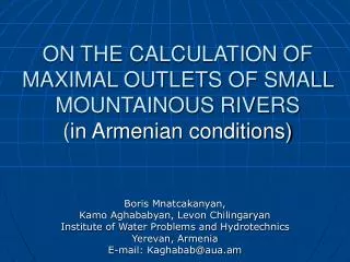
Map-Scheme of Marmarik River Basin 1- gauge line Marmarik-Hanqavan, 2 – gauge line Marmarik – Aghavnadzor, 3 – gauge line Gomur - Meghradzor
Actually, this pond hydrologically is rather well-investigated. The area of the pond is not so large, that why the regional method could be applied here. The consumption and hydrographs of maximal flow by P=0.01%, 0.1%, 1%, 5%, 50% provision are determined for the calculating river site. For the comparative estimation of the methods, beside the consumtion of Qp, and their statistical characteristics (Cv, Cs, RAUT), another important parameter (the reduction indicator n of the flow maximal modulus) choosen. The latter is defined by the relation Q2 / Q1 = ( F2 / F1)n, where Q1, Q2 are the quantity of consumtion; F1, F2 are the areas of reservoir, corresponding with two sequenced calculated sites of river.
The results of the calculations show, that the quantities of the consumtion with the same provisions, made by regional methods, are considerably more, than the results made by normative methods, admitted by hydrology. The difference of the parameters of reduction of flow maximal modulus, determined by this methods, is also considerable. This analysis, not detailed essentially, shows the way of improvement of regional methods and its difficulties.
Conclusions 1.The norms and methods of defining the parameters of maximal runoft need to be improved and regulated for their use under different conditions, scales and certain soluable issues. 2.The improvement of the regional methods is possible by means of application of comparatine analysis with tested normative methods, which are applied for rivers under study. 3.Alongside the improvement of regional methods it is crucial to select the structure of calculation formulae and reduction coefficient.