Download
1 / 1
10 likes | 158 Views
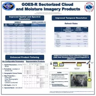
GOES-R Sectorized Cloud and Moisture Imagery Products. Bill Campbell, Brian Gockel , and Jim Heil (NOAA/NWS) Marge Ripley and Jean-Jacques Bedet (NOAA/NESDIS/GOES-R). Improved Spatial and Spectral Resolution. Improved Temporal Resolution. GOES-R. GOES-13/GOES-15. Refresh Rates.

E N D
GOES-R Sectorized Cloud and Moisture Imagery Products Bill Campbell, Brian Gockel, and Jim Heil (NOAA/NWS) Marge Ripley and Jean-Jacques Bedet (NOAA/NESDIS/GOES-R) Improved Spatial and Spectral Resolution Improved Temporal Resolution GOES-R GOES-13/GOES-15 Refresh Rates Satellite (MODIS) Schmitet al, 2005 Enhanced Product Tailoring GOES-R Sectorized Cloud & Moisture Imagery (CMI) Data Streaming from Ground Segment to AWIPS NCF Six Configurable Parameters Representative Products NOAAPort/ SBN Last Packet Product Distribution AWIPS NCF Product Generation 1. Spatial Resolution— 0.5 to 28 km 2. Periodicity—multiple of refresh rate 3. Geographic Corner Points 4. Map Projection— Fixed grid Polar Stereographic Mercator Lambert Conformal 5. Bit Depth— 8 to 14 6. Spectral Band— see above GOES-R Ground Segment (GS) NetCDF4 file (one tile, a partial image) GOES-R/AWIPS Demarcation • Key Points • Sectorized CMI data streaming from GOES-R Ground Segment (GS) into AWIPS. • Each netCDF4 file contains one tile. • Each tile is a subset of a complete satellite image. • Tile size will be configurable (e.g., 1024X1024 pixels). • Meets Latency Requirements*: • 23 seconds for Mesoscale Scan; • 50 seconds for Full Disk and CONUS scans This Image is an example only Decode AWIPS Field Nodes (WFOs, RFCs, Nat. Ctrs.) * 12 bits at all channels except 14 bits for the 3.9 Micrometer channel *Latency: Time between arrival of last data packet of an observation at the GOES-R GS and the arrival of the last bit of the corresponding GOES-R product at the AWIPS Demarcation Point.