Download
1 / 23
240 likes | 425 Views
Until recently, GIS professionals overlooked error management, but it is now crucial for database functionality. By being aware, scrutinizing, and planning carefully, errors can be minimized, enhancing decision-making. Definitions of accuracy and precision are vital, as they impact data quality and cost. Positional accuracy, attribute accuracy, and conceptual accuracy must be considered to maintain GIS integrity. Sources of error, including obvious sources and those from natural variations or processing, necessitate thorough understanding for effective error management. Various error types like numerical and topological errors pose challenges in GIS data accuracy. Successful GIS operation requires meticulous attention to error control and precision standards.

E N D
Managing Error, Accuracy, and Precision In GIS
Importance of Understanding Error *Until recently, most people involved with GIS paid little attention to error *That situation has now changed dramatically *Error management is a vital role to the proper functioning of a GIS database, and is subject to a large percentage of work in most GIS shops
Importance of Understanding Error *The key point is that through awareness, scrutiny, and careful planning can minimize these errors and their associated effects on management and decision-making
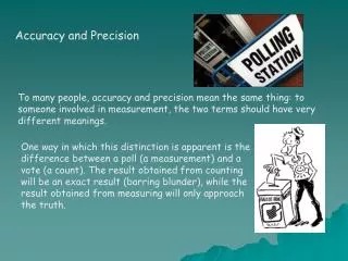
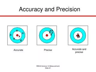
Definitions for Understanding Error *Accuracy: the degree to which information on a map or in a digital database matches the true or accepted values -can vary greatly amongst datasets -very high accuracy can be expensive *Precision: refers to the level of measurement and “exactness” of description
Definitions for Understanding Error *Precision: refers to the level of measurement and “exactness” of description in a GIS -again, precision requirements vary greatly depending on the dataset -highly precise data can be much more expensive to create
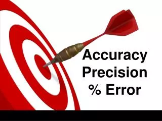
Definitions for Understanding Error Accuracy vs. Precision . . .
Types of Error Positional Accuracy and Precision *Refers to both horizontal and vertical positions *Don’t use/compute locational information at a level beyond which the data was intended Accuracy Standards for US NTS Maps 1:1,200 ± 3.33 feet 1:2,400 ± 6.67 feet 1:4,800 ± 13.33 feet 1:10,000 ± 27.78 feet 1:12,000 ± 33.33 feet 1:24,000 ± 40.00 feet 1:63,360 ± 105.60 feet 1:100,000 ± 166.67 feet
Types of Error Attribute Accuracy and Precision *Attribute (non-spatial) information can also be erroneous *Some layers can be more precise than others Conceptual Accuracy and Precision *Use of inappropriate categories, or misclassification *Ex.-not classifying voltage in your power lines layer would limit your ability to manage electrical utilities infrastructure
Sources of Error *Sources of error can be divided into three groups: -obvious sources of error -errors resulting from natural variations or from original measurements -errors arising through processing
Obvious Sources of Error *Age of Data -some data sources may be too old to be useful -past collection standards may no longer be acceptable -the database could have changed dramatically over time (erosion/deposition, harvest, fire) -updating a database is by far the most common form of error management work
Obvious Sources of Error *Areal Cover -some datasets contain only part of the required information (veg., soils are common) -ex. FRI often contains no land cover information for wetland areas -some remote sensing data may be difficult to acquire consistently cloudy regions
Obvious Sources of Error *Map Scale -always remember the implications of scale!!!! *Density of Observations -an insufficient number of observations may not provide the required level of resolution -ex. If you have a 40’ contour interval, you had better not be reporting on or making decisions about features only a few feet in difference
Obvious Sources of Error *Relevance -surrogate data may be used to indirectly describe/classify/quantify features -Ex. We can create a forest polygon layer from classification of remotely sensed data. However, we are not classifying a “tree” as a tree. Rather, we are classifying the imagery based on spectral signatures, and those signatures can be related to tree species.
Obvious Sources of Error *Format -methods of formatting data can introduce errors -conversion of scale, projection, or datum, vectorization/rasterization, and pixel resolution are possible areas of format error -international mapping standards not established
Obvious Sources of Error *Accessibility -try getting a highway map of the former USSR in the Cold War days . . . Good Luck! *Cost -highly accurate, precise data is expensive!!!
Errors from Natural Variationor from Original Measurements *Positional Accuracy -many natural features do not exhibit “hard” boundaries like roads or boundary lines -examples include . . .?
Errors from Natural Variationor from Original Measurements *Positional Accuracy -many natural features do not exhibit “hard” boundaries like roads or boundary lines -examples include: -soils -vegetation communities -climate variables -drainage -biomes, etc.
Errors from Natural Variationor from Original Measurements *Accuracy of Content -qualitative accuracy refers to correct labelling/classification (Ex.-pine forest vs. spruce forest) -quantitative inaccuracies often occur from faulty equipment or poor readings -what forestry equipment could give you bad data? And how?
Errors Arising Through Processing *Numerical Errors -by far, the hardest errors to detect!!! -different (faulty) computer chips can compute differently, generating a different output (response) *Topological Errors -overlaying, or deriving/creating new variables based on other data can cause slivers, overshoots, and dangles
Errors Arising Through Processing *Classification/Generalization Errors -classification inaccuracies/class merging -grouping data in different ways can lead to dramatically different results (Ex.-studying cause of death amongst males would probably be quite different if you had (amongst others) an aged 18-25 group vs. an 18-50 group
Errors Arising Through Processing *Geocoding/Digitizing Errors -what can cause digitizing errors?
Errors Arising Through Processing *Geocoding/Digitizing Errors -what can cause digitizing errors? -rasterizing will cause positional error
Error, Error, Everywhere . . . How can we manage error? 1. Be aware of where error can be generated (everything discussed in this presentation) 2. Metadata, metadata, metadata . . . Fully understand all data compiled for your GIS, make notes of all work done with the data, and send such information to future users or with all GIS generated output.