Review
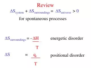
Review. October 29. Geostrophic Flow Thermal Wind Vorticity Sverdrup, Stommel, and Munk Western Intensification – Beta-Effect Planetary Waves – Rossby and Kelvin Coastal Upwelling Deep Circulation – Thermohaline or Meridional Overturning Circulation


Review
E N D
Presentation Transcript
Review October 29
Geostrophic Flow Thermal Wind Vorticity Sverdrup, Stommel, and Munk Western Intensification – Beta-Effect Planetary Waves – Rossby and Kelvin Coastal Upwelling Deep Circulation – Thermohaline or Meridional Overturning Circulation Equatorial Circulation – Eq. undercurrent, Eq. upwelling ENSO Monsoonal Circulation
Geostrophic Equations Where f=2Ωsinθ, the Coriolis parameter Rearranging, the equations become: p0=atmospheric pressure at z=0 and ζ is the height of the sea surface
Hi P Lo P Lo P cf pgf pgf cf ρ=const u,v=const w/z
Top view Side view Local z Rotation about local z relative to fixed space N Pole Vorticity • Vorticity – tendency to rotate • Like angular momentum – must be conserved • Planetary vorticity - f Eq.
y u2 v2 u1 v1 x • Relative Vorticity – ω – current shear Positive rotation (RH rule) Negative rotation
Rearranging, we get: or where β = ∂f/∂y is the rate of change of Coriolis parameter with latitude, and where curlz (t) is the vertical component of the curl of the wind stress.
So again – Dissipation of Vorticity + Redistribution of Vorticity = Input of Vorticity
Let’s Review: Equations of Motion Linear momentum Continuity
Balance Between: Gives: A: 1 – 3 Inertial Oscillations B: 2 – 3 Geostrophy (frictionless) C: 2 – 3 – 5 Sverdrup (1947) (play tricks) D: 2 – 3 – 4 – 5 Munk (1950) solution (Stommel (1948) simplified eddy viscocity) B still applies in C and D – they were derived from B by looking at vorticity in addition to linear momentum Fundamental assumption in B, C, and D is “Steady” – no change with time
Ekman transport – Ekman Pumping – Vortex Stretching/Comperession
Sverdrup + Lateral drag/Eddy Viscocity = Stommel/Munk Gyres A A’
Recall…. Where F (x) and F (y) are all those “friction” terms
heating cooling Thermohaline circulation Eq 80N CLASSICAL MODEL ONLY
Figure 13.4 in Stewart. Sketch of the deep circulation resulting from deep convection in the Atlantic (dark circles) and upwelling through the thermocline elsewhere. After Stommel (1958).
Figure 13.5 in Stewart. Sketch of the deep circulation in the Indian Ocean inferred from the temperature, given in °C. Note that the flow is constrained by the deep mid-ocean ridge system. After Tchernia (1980).
Figure 13.10 in Stewart. Contour plot of salinity as a function of depth in the western basins of the Atlantic from the Arctic Ocean to Antarctica. The plot clearly shows extensive cores, one at depths near 1000 m extending from 50°S to 20°N, the other at is at depths near 2000m extending from 20°N to 50°S. The upper is the Antarctic Intermediate Water, the lower is the North Atlantic Deep Water. The arrows mark the assumed direction of the flow in the cores. The Antarctic Bottom Water fills the deepest levels from 50°S to 30°N. See also Figures 10.16 and 6.11. From Lynn and Reid (1968).
Antarctic Circumpolar Current Figure 13.12 in Stewart. Cross section of neutral density across the Antarctic Circumpolar Current in the Drake Passage from the World Ocean Circulation Experiment section A21 in 1990. The current has three streams associated with the three fronts (dark shading): sACCf = Southern ACC Front, PF = Polar Front, and SAF = Subantarctic Front. Hydrographic station numbers are given at the top, and transports are relative to 3,000 dbar. Circumpolar deep water is indicated by light shading. From Orsi (2000).
Figure 13.13 in Stewart. Distribution of the Subantarctic and Polar Fronts and associated currents in the Antarctic. From Whitworth (1988).
For west propagation: if u=0, then ς=0 ς=0 ς=0 C<0 ς<0 ς>0
Coastal Upwelling • Mid-ocean upwelling – driven by Ekman divergence • Get Ekman divergence at coast due to alongshore winds, offshore Ekman transport, and coastal boundary – leads to Ekman divergence at coast • Along-shore current driven by geostrophic pressure gradient – vertical shear – possible reversal with depth Alongshore current x Thermocline
A’ ME τ(x) Equator B’ B f=0 τ(x) ME A Equatorial Upwelling – Ekman divergence at Equator due to change in sign of Coriolis acceleration f
Equator A A’ pgf pgf f<0 f=0 f>0 Pycnocline is lifted at the Equator, pressure gradient force drives equatorial under current
Sea surface slopes up to the West B’ B pgf East – West slope of the pycnocline Surface current driven by wind is confined to the mixed layer
Cp Sea surface pycnocline Barotropic Wave • Ocean’s response to changing winds • external (Barotropic) waves: Sea surface and density surfaces move together – motion independent of depth
Cp Sea Surface pycnocline Baroclinic Wave • Internal (Baorclinic) waves: Sea surface and density surfaces move in opposite directions • Motion varies with depth
p increasing Hi Hi p decreasing divergence Lo pgf Cf C Lo convergence pgf is balanced by Cf p increasing Hi v=0 Top View • Coastal Kelvin waves get trapped against horizontal boundary Side View Propagate with coast to right in Northern Hemisphere Carry upwelling or downwelling signals Along coast
for baroclinic waves Wave Phase Speed: ~0.5 to 3 m/s for barotropc (external) waves • L: measure of how far a water parcel can travel before it is affected by Coriolis: • f is smallest near the equator and largest near the poles, L increases toward the equator, coastal waves are not trapped at the equator
pgf pgf pgf Divergence Convergence Lo Hi Lo Equator pgf pgf pgf C Equatorial Kelvin Waves • Equator acts like a coast, with water on either side Equatorial Kelvin Waves move only to the East Le ~250 km, C~3 m/s
τ(x) τ(x) z=0 surface 80 m pycnocline 300-400 m Eq. under current 180° El Niño “Normal” state – Trade Winds pile up water in west
El Niño τ(x) τ(x) z=0 surface 200 m 200 m pycnocline Eq. under current 180° El Nino state - Winds relax or even reverse in western and central Pacific – pycnocline flattens out, undercurrent stops
equator Change in Trade Winds generate Kelvin wave that propagates eastward, depressing the pycnocline as it goes
pyc. depressed pyc. uplifted upwelling shuts off In 2-3 months – Kelvin Wave hits the coast of South America, part of it reflects as a RossbyWave, part moves poleward as a coastal Kelvin wave
CKW California Current Rossby Wave Rossby Wave Humbolt Current Coastal Kelvin Waves (CKW) go all the way to Canada and Chile, altering Eastern Boundary Currents and shutting down upwelling – Also influence ACC
ENSO Indiceshttp://ioc3.unesco.org/oopc/state_of_the_ocean/all/
Niño 3.4 The Niño3.4 SST anomaly index is an indicator of central tropical Pacific El Niño conditions. It is calculated with SSTs in the box 170°W - 120°W, 5°S - 5°N.
http://www.pmel.noaa.gov/tao/elnino/nino-home.html Present anomalies are small – near “normal” conditions
Southwest (Summer) Monsoon Currents A schematic representation of identified current branches during the Southwest Monsoon, including some choke point transport numbers (Sv=106m3s−1). Current branches indicated are the South Equatorial Current (SEC), South Equatorial Countercurrent (SECC), Northeast and Southeast Madagascar Current (NEMC and SEMC), East African Coast Current (EACC), Somali Current (SC), Southern Gyre (SG) and Great Whirl (GW) and associated upwelling wedges, Socotra Eddy (SE), Ras al Hadd Jet (RHJ) and upwelling wedges off Oman, West Indian Coast Current (WICC), Laccadive High and Low (LH and LL), East Indian Coast Current (EICC), Southwest and Northeast Monsoon Current (SMC and NMC), South Java Current (JC) and Leeuwin Current (LC). From Schott and McCreary, 2001, Progress In OceanographyVolume 51, Issue 1 , Pages 1-123
Northeast (Winter) Monsoon Currents From Schott and McCreary, 2001, Progress In OceanographyVolume 51, Issue 1 , Pages 1-123
Upwelling signal in northwestern Arabian Sea during southwest monsoon