Download
1 / 59
590 likes | 680 Views
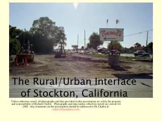
The Rural/Urban Interface of Stockton, California.

E N D
The Rural/Urban Interface of Stockton, California Unless otherwise noted, all photographs and data provided in this presentation are solely the property and responsibility of Richard Chabot. Photographs and data (unless otherwise noted) are current for 2005. Any comments on this presentation should be addressed to Dr. Chabot at: rchabot@humphreys.edu.
You’ve Heard This Before. . . • California is the most populous and the fastest growing state in the U.S. • From 36 million people today, we are projected to be home to more than 50 million people by the year 2040. • One impact of this population growth is the expansion of urban boundaries into rural areas, farming communities, and animal habitats.
Farming in California • Agriculture is unquestionably California’s greatest asset, economically and culturally • Yet this map provided by the American Farmland Trust shows prime farmland to be in extreme danger of development www.farmland.org (Stockton is located here)
The California Department of Conservation estimates that 19,000 acres of land in only five counties (Fresno, Kings, Merced, Madera, and Tulare) were converted from farmland or grazing land to non-agricultural uses between 2002 and 2004. This equals an average of nearly 26 acres a day. While devastating for California farms and our agricultural future, we must also concern ourselves with the types of communities this development is creating
Statewide urban development marginally increased since 1998-2000, but continued its inland encroachment. The San Joaquin Valley’s urbanization rate increased more than 75% in 2000-2002.California Division of Natural Resource Protectionhttp://www.consrv.ca.gov The above developments are provided by, among others, Spanos and Grupe Developers in Stockton, CA. “Urban land expanded by 92,750 acres during the 2002 mapping cycle, with nearly 25% occurring in the San Joaquin Valley. The inland empire counties (Riverside and San Bernardino) and the six-county Sacramento metropolitan area accounted for 22% and 14%, respectively, of the statewide total. Land idling, ecological restoration, rural residential development, and mining operations also effected downward pressure on the agricultural total. Partially countering the decreases were new orchard plantings in foothill areas and a resurgence of carrot and potato cropping in the Antelope Valley (Los Angeles County). The net decrease in irrigated farmland, 53,963 acres, was dominated by losses to Prime Farmland (47,172 acres) during the two-year period.” California Division of Natural Resource Protection
San Joaquin County, Californiahttp://www.sjpnet.org/ Population: 650,000 • Agriculture used to be the county’s economic mainstay • $1.5+ billion in 2004 • Construction has now surpassed this • $1.7+ billion The land for this development used to provide strawberries to the people of Stockton
San Joaquin County Median Family Income: $46,919 Median home-sales prices have been climbing. In spring 2006, the median home price for San Joaquin County was $421,000 and $364,000 in Stockton. (According to figures from the latest TrendGraphix survey) Prices have been going down in a softened housing market, but plans for future growth remain. None of the developers are selling out to farming co-ops or turning their riverfront properties into parkland.
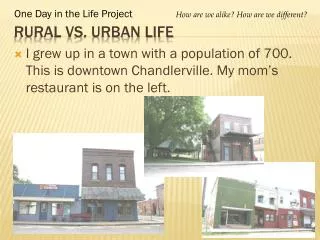
Stockton, CA • Stockton 2006 • 280,000 people and in 2004 ranked 5th fastest growing city in the nation (#1 in CA!) • Once known for crime and boredom • Now nationally known for high housing prices and a construction boom • This photograph shows the sign of the times
Population in San Joaquin County and Stockton proper has boomed , some would say uncontrollably, especially over the last four years
Cities Rulehttp://www.westplanning.com/docs/stockton/documents.htm#maps “In California, virtually all land-use planning and permitting powers are delegated to cities (inside their boundaries) and counties (in unincorporated areas). Although these local governments are required to engage in comprehensive land-use planning efforts, there is no requirement that they coordinate their efforts on a regional or sub-regional level. Each city and county is permitted to pursue its own land-use planning and permit efforts independently.” (p. 4) Quoted from the Public Policy Institute of California publication Urban Development Futures in the San Joaquin Valley (2005) Photograph shows construction of a new part of Frontage Road, near Hammer and Hwy 99, in part of the Oregoni cherry/walnut orchard.
Spring 2005 • Stockton, like other valley cities, has grown with the influx of workers from Sacramento or the Bay Area looking for cheaper housing • The city doesn’t mind the growth; the construction provides great tax revenues • Long term residents are less enthusiastic • Traffic at the intersection of Hammer and Hwy 99
Spring 2005 Change comes quickly to a cherry orchard at Hammer and Hwy 99 This shows the start of a new interchange that will widen an overpass as well as the on- and off-ramps for motorists in Northeast Stockton. With the recent addition of a Super WalMart, Lowes, and new housing subdivisions, longtime local residents are unsure whether to cheer a wider better road system to handle the heavy increase in traffic or cry for the loss of surrounding orchards and farmland. For more information on highway “improvements” in the area, go to http://www.dot.ca.gov/dist10/stip_shoppe_maps/San_Jo_%20Stip%20copy.pdf Spring 2006
What does the scream of a cherry tree sound like? This will be part of the new Highway 99 interchange discussed in the previous slide.
Morada, CA Once located on the far edge of the city, this community is soon to be overrun by Stockton’s growth. This farmland is just around the corner from the cherry orchard pictured on the previous slide. It was recently “acquired” from San Joaquin County by the City of Stockton and is soon to be home to approximately 2,100 new houses. Residents of Morada question the wisdom of such growth when tax revenues are placed above community cohesiveness and sound urban planning practices.
The southern tip of Morada with endangered cherry orchards and fields, soon to be a 2100 mass of homes and commercial space serving the City of Stockton (See next slide) Highway 99 Cherry Orchard Productive Field Hammer Lane Another Cherry Orchard
What the City of Stockton Envisions. . . replacing those cherry trees and fields with a “village” In their words, this will be. . . • A walkable, comfortable and interconnected community that is easy to get around • An interesting, distinctive and visually appealing place to call home • A community that is functional convenient and offers more than just the “basics” For more visit http://www.stocktongov.com/CD/PlanningDivision.cfm The people of Morada have been very vocal in their opposition to this prettified rendition of tomorrow’s urban reality (drawn by the Dahlin Group) Residents to the south of this development are also beginning to stand up and say no.
Farms and orchards throughout the valley are being broken up and sold as housing lots. The eastern edge of Morada (just down the street and across from the farm shown in the previous slide) is witness to this phenomenon. Any guess as to how much these empty, barren 2-acre lots are going for? Each of these 2-acre lots is going for well above $500,000.00. No, that’s not a typo. Yes, just the empty lot. There are five 2-acre sites available here
Small farms are often split up into 2 to 5 acre lots, allowing buyers to build large sprawling homes on their estates or pretend they are “gentleman farmers.” Reality being what it is, most of what is built in California is “the box” on tiny lots.
Robert Frost would not be happy. . . Walls are a common part of new developments. Even along two-land side-streets, the new homes are walled-off from existing developments. You can walk miles down quiet side streets and never see more than the roof of a house and entrance (only rarely gated) to the cookie-cutter but cutely* named subdivision. Note that even on very wide two-lane side streets lining the walls, parking is not allowed. * Oak Grove, Lone Meadows, Hesperion, Cinnamon Bar, etc.
On the northern edge of Morada, a new walled-off housing “community” grows in the middle of a field.
Morada Market A small, family run business and an important part of the Morada community. For more on Morada, contact http://www.moradacal.com/ While more people could mean more business for the market, the sprawl of Stockton has also brought in a Super Wal-Mart and another national grocery chain claiming 11 acres of farmland down the street. If you hate big boxes, try visiting this site: http://www.sprawl-busters.com/victoryz.html
This cherry orchard is located at the newly expanded east end of March Lane. The end of the road, like the edge of this new subdivision, is only temporary. Plans are underway to “punch through” the orchard and link this main thoroughfare with Highway 99
One of the perks of living in Stockton is the fresh fruit and produce. The Oregoni family staff their own roadside cherry stand near the corner of Hammer and Highway 99. The following slide shows the same location as spring 2005 turns to summer.
A few weeks after the photo in the previous slide was taken, construction began in earnest to replace much of the Oregoni cherry/walnut orchard with highway access roads and commercial development
Spring 2005 Another part of the Oregoni orchard making way for another access road and more square feet of commercial space. This particular (soon to be) road is located just behind the Home Depot on Hammer near Highway 99.
Just across the street from the previous photograph are new homes and, of course, commercial space.
Part of the Oregoni orchards has been taken over by a large high school, newly opened and attended by approximately 1800 students.
Although the school pictured in the previous slide is vital to the community and its children, John Oregoni worries that the rights of the students will outweigh his right to care for and harvest from a large portion of the remaining orchard. The Oregonis have largely come to accept the inevitable paving of their family heritage, trying to maintain some control over what does happen to the land while investing in orchards further from the reach of the City of Stockton.
Another high school being built on West Avenue near Eight Mile Road. A middle school is soon to follow. These facilities are coming too slow to meet Stockton’s growing population, yet it’s the surrounding farmland that suffers as it disappears under the pavement.
Eight Mile Road Grapes, corn, strawberries, and alfalfa are common sights driving down Eight Mile Road Eight Mile Road is a dividing line north of Stockton, a two-lane corridor that used to pass through endless fields of corn and grapes, separating the town of Lodi from Stockton. For Sale signs seem to be the latest money crop
No more. Here we see the beginning of a widening of Eight Mile Road into an eight lane super-conductor for trucks and commuters.
A major industrial development and housing complex is planned for this area of Eight Mile Road near Highway 99 This old cannery, a Stockton landmark, used to provide hundreds of full-time and seasonal jobs tied to our agricultural heritage.
More of the future on Eight Mile Road Signs of the times in rural Stockton. A crop of hay turns into a crop of houses
This road connecting Stockton and Lodi is being widened in response to the increased traffic between the two cities. The present greenbelt that separates these two urban areas will probably be nonexistent in twenty years.
The Eastern end of Eight Mile Road, as it crosses Highway 99, is already coming under the bulldozer rather than the plow. Apart from the continued loss of high-quality farmland, the homes, gas-stations, and strip-malls that will cover this land will also affect the previously isolated community of Morada that is just across the (for now) two lane overpass.
Northwest Stockton, showing areas for development now and into the future near I-5 and the west end of 8-Mile Road This area is now fully developed with super-stores and condos. The growth continues to expand outwards into the delta, farmland, and existing communities. I-5 Eight Mile Road
At the west end of Eight Mile Road, just south of the previous slide, a newly proposed development will continue this expansion of Stockton into what is presently 1300 acres of farms and wetlands. This includes more than 7,500 housing units as well as retail and office space.
Just North of the Spanos Site, At Hammer Lane and Interstate 5 • In May 2005, Grupe announced plans to develop the 1,700-acre Shima Tract, a Delta island west of Interstate 5 at Hammer Lane, into a 7,000-home community. The $3 billion project is planned to unfold over the next 18 years. This is just south of the previous two slides
South and West of Stockton. . .are bedroom communities sprouting up to serve the San Francisco/Bay Area • Situated on prime farmland, the new homes will serve the needs of local valley residents as well as Bay Area commuters. The homes are large, upscale, and too expensive for the local median wage earner.
Lathrop. . . Just south of Stockton Housing developments totaling more than ten thousand homes are replacing agricultural land along river-front property. Further developments are expected until something finally floods or profits fall
MossdaleLandingA New Master-Planned, Riverside Community in Lathrop, California(As you saw in the previous slide, more are on the way) This agricultural floodplain is slowly being filled in by new homes A 300,000 sq. ft. commercial center is planned for this corner of the pictured housing development. Map, logo, and homes courtesy of Pacific Union Homes, among others
As of 2006, Lathrop is growing faster than Stockton. Many of these new residents are commuters to the Bay Area. This graph is from the Stockton Record
Are these photos of disappearing farmland or a robust economy?
Just a mile down the road (closer to SF) from the previous photographs sits farmland on the edge, still producing but awaiting its inevitable fate. At the I-5/205 cutoff to SF, developers have plans for thousands more homes and some commercial development to cover this historic riverfront floodplain.
South and to the East of Stockton: Prime farmland along Highway 4 A public ballot measure approved the commercial and residential development of a large chunk of agricultural land between Hwy. 4 and Mariposa Rd. This slide shows land at the Highway 4 and Highway 99 interchange, ready for commercial development. This farmland further east up Highway 4 is considered by the City of Stockton as a perfect place for new homes, but plans have not been finalized..
Just south of Hwy. 4 more development is planned, but without thought of it’s impact on existing businesses and activities. Here, 2500 residential units are to be built, some just under a landing pathway for jets using the Stockton airport. The developer is sure homeowners won’t mind the noise or pollution. Thanks to the Stockton Record for this graphic.
The town of Linden is located just east of Stockton. A small community framed by its many fruit orchards, locals are worried about what development may bring to their way of life.
This is greater downtown Linden, an unincorporated town with an unofficial population of about 1,500 people. Though it looks like a sleepy little burg, it is actually the center of an agricultural gem, growing some of the finest walnuts and cherries America has to offer. It”s orchards and farmland are dissected by Highway 26, linking the foothills to the Central Valley.
A Bird’s Eye View of Linden A 76 home subdivision is being built on this lot (with no cheers from the neighbors)
Jay Colombini is a third generation rancher in the Linden area and member of the school board. He was happy about some economic revitalization in the Linden area but noted that locals are wary of development, especially any large housing projects that may change the area’s economy or sense of uniqueness.