Download
1 / 16
160 likes | 417 Views
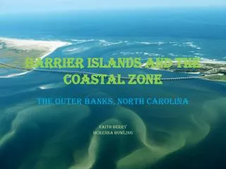
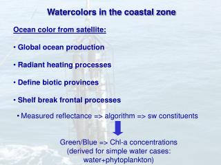
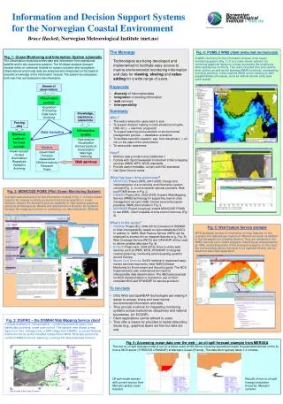
Monitoring the Norwegian Coastal Zone Environment by Johnny A. Johannessen and Nina Winther. Ocean Color Satellite Image. Algae concentration-distribution. Northeast Atlantic in TOPAZ. Bathymetric Map. MONCOZE Main Goal.

E N D
Monitoring the Norwegian Coastal Zone Environment by Johnny A. Johannessen and Nina Winther
Ocean Color Satellite Image Algae concentration-distribution Northeast Atlantic in TOPAZ Bathymetric Map
MONCOZE Main Goal Develop, test and demonstrate a pilot system for monitoring and prediction of the Norwegian Coastal Zone Environment, with special focus on current, temperature and salinity and their influence on water quality (primary production, eutrophication and harmful algal blooms). Bruce Hackett, Lars Petter Røed, Jon Albretsen (met.no) Einar Svendsen, Henrik Søyland, Morten Skogen, Didrik Danielsen (IMR) Johnny A. Johannessen, Nina Winther, Lasse Pettersson, Laurent Bertino (NERSC) Funded byNorwegian Research Council 2001-2005
MONCOZE APPROACH ATMOSPHERIC FORCING SATELLITE OBSERVATION KATEGATT SKAGERRAK NORTH SEA …………….. …………… …………… …………… JASON, Envisat NOAA, SeaWiFS IN SITU OBSERVATION TOPAZ, HYCOM, MIPOM, NORWECOM Buoys, drifters Coastal Observatory OBSERVING SYSTEMS MODELLING SYSTEMS
Horizontal view 3D view 3D Physical Model Wind Stress Cloud Cover River Inputs Heat Flux Boundary Conditions Detailed land mask and bathymetry Current, temperature, salinity, sea level
TEMPERATURE Model Products - current & temperature PHYTOPLANKTON
SAR IMAGE VERSUS MODEL - INTERCOMPARISON ASAR, 9 May 2003 MODEL, 9 May 2003
Validation of Model Products - Salinity TORUNGEN-HIRTSHALS
SERVICES - OIL SPILL MONITORING AND DRIFT PATTERN Occurrence of spills in 2000 from ESA ERS SAR
Coupled Physics-Ecosystem Model Irradiation Pelagic Model Wind Stress Cloud Cover Small Cells Large Cells River Inputs Nutrients Si Phytoplankton NO3 Pico- Flagellates Diatoms Heat Flux Organics Particulates CO2 NH4 Bacteria PO4 Dissolved Hetero- trophs Boundary Conditions Micro- Meso- Zooplankton C,N, P,Si Sed ERSEM S,T,SPM, K,u,v,w Detritus Phyto- plankton Nutrients Pelagic Suspension Feeders D e t r i t u s Aerobic Bacteria N u t r I e n t s Oxygenated Layer Meio- benthos Deposit Feeders 3D Baroclinic Hydrodynamics Redox Discontinuity Layer Anaerobic Bacteria Benthic Model Reduced Layer
From MONCOZE to Operational Oceanography • Monitoring - Satellite observations - in-situ observing network - rapid transmission - near real time processing and distribution. • Modeling - State characterization and prediction - episodic occurances of extreme events - reanalyses - time series. • Products - Current and eddies - temperature - salinity - layer structure - sea level - algae concentration and distribution - eutrophication - pollution - oil dispersion and spreading. • Services - Routine information flow to public and specialized users • Management - More reliable impact, effect analyses, reporting • Security - Ship detection, Search and Rescue, Pollution monitoring
From MONCOZE to Operational Oceanography ARE WE DONE??? ---ON THE WAY BUTNEED ADVANCES IN • Coverage of the entire Norwegian Coast • In-situ observing network with rapid transmission and near real time processing (ships, buoys,gliders). • Coastal observatories at tie-point including HF-radar (CODAR) systems. • Hydrological modelling-river runoff-nutrient loads • Ecosystem modelling and two-way nesting of models into the fjords with very fine (100 m) resolution. LETS HOPE WE HAVE THIS IN PLACE BEFORE THE BIG ENVIRONMENTAL DISASTER HAPPENS WITHIN OUR EXCLUSIVE MARINE ECONOMIC ZONE