Download
1 / 38
380 likes | 573 Views
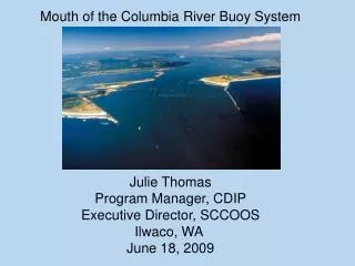
Mouth of the Columbia River Buoy System Julie Thomas Program Manager, CDIP Executive Director, SCCOOS Ilwaco , WA June 18, 2009. C OASTAL D ATA I NFORMATION P ROGRAM. • Based at SIO • 39 Wave Stations • 14 People • $2.5M+ / year budget • Funded by: CDBW USACE

E N D
Mouth of the Columbia River Buoy System Julie Thomas Program Manager, CDIP Executive Director, SCCOOS Ilwaco, WA June 18, 2009
COASTALDATAINFORMATIONPROGRAM • Based at SIO • 39 Wave Stations • 14 People • $2.5M+ / year budget • Funded by: CDBW USACE (SCCOOS BEACON ONR SD Foundation…) CDIP Mission • Develop US nearshore wave climatology for more rational design decisions
OUTLINE • Overview of the Coastal Data Information Program (CDIP) • Overview of the Datawell Wave Buoys, moorings and deployment vessels. • Examples of existing customized Port products: - Los Angeles/Long Beach – San Pedro Channel- San Francisco • Mouth of the Columbia River – location • Funding • Examples of CDIP Products • Reliability Statistics
CDIP Wave Buoys Near Ports and Harbors How important is consistency for The inter and intra-state maritime community? Each port has its own unique Set of challenges…no one Template fits all! Port/Harbor buoys Other CDIP wave buoys
Integrated Ocean Observing System (IOOS) • Supports Science, Engineering, and • Marine Safety • Sponsored by NOAA and USACE • Plan Approved by IOOS Program • Office, March 2009 • Strategic placement of wave buoys for integration with global • and local wave models. • High wave data quality standards
Constructed in the Netherlands, robust, • reliable. Considered as the base system • for wave buoy comparisons in the International Community (JCOMM) • Centimeter accuracy in the wave height, • 5 degrees resolution for wave direction. • Data are transmitted via iridium satellite. • (full xyz and spectra are transmitted) . All raw data are stored on board. • - All data are disseminated on the CDIP • Website in near real-time. The data • update @ 30 minutes. • The parameter (Hs, Tp, Dp, SST ) and spectral data are transmitted to NDBC @ hour. Via AWIPS, data are transmitted to the NWS Office. • Alert system if buoy breaks loose. DATAWELL Directional Wave Buoy
MOORING SYSTEM • 30 m bungee that allows for surface following buoy. Bungee stretches to 4 x its length • - Polypropolene line • 1400 lbs of large anchor chain Compliant mooring System designed to maximize the frequency response of the buoy Instrumentation.
Gray’s Harbor Installation 1981 – present Max Hs = 12m (2/06)
Umpqua (1/06) Max Hs = 10.3m (1/07) Cape Mendocino (3/99) Max Hs = 9.98m (12/08)
The Coastal Wave Network Template • Regional waves are monitored by a pair of Outer & Inner Shelf Buoys. outer Shelf Break inner Harbor PLAN VIEW SHELF CROSS-SECTION
The Coastal Wave Network Template • Outer/Inner wave buoys are placed at wave model boundaries for assimilation and validation. Local Model Global Model Shelf Model Shelf Model Shelf Break Local Harbor Model CROSS SECTION PLAN VIEW
Waves and Currents in the San Pedro Channel SCCOOS providing currents CDIP providing wave observations, Nowcasts and forecasts. http://sccoos.ucsd.edu/themes/harbors
Ports of Los Angeles/Long Beach Website allows you to click on your area of interest for further details. Catalina
3 day wave forecast Capability to send automated notification when thresholds are exceeded!
SAN FRANCISCO BAR BUOY Buoy-driven wave model predictions CDIP Point Reyes Buoy Long Period Swell CDIP Bar Buoy Short Period Seas Swell + Sea Prediction NOAA 46026
Step 1. Validate Buoy-driven Regional Wave Transformation Hindcast at Bar Buoy. Red=Model Blue=Bar Buoy February 2008 HINDCAST VALIDATION
Feb 23, 2008, 9pm. PST 3 m, 10 sec Breaking Waves on the San Francisco Bar
Feb 24, 2008, 3p.m. PST 6 m, 14 sec Breaking Waves on the San Francisco Bar
Marine Incidents near SF Bar Incidents in the Vicinity of SF Bar
Additional Comments (by BOR) ADDITIONAL COMMENTS (BILL O’REILLLY) MCR The buoys can be used to both drive coastal wave models at the offshore and nested nearshore boundaries (hindcasts and nowcast) as well as validate basin- and regional-scale ww3 model forecasts at these critical hi res coastal model "handoff" locations. You can use them in a more regional way. eg. to make wave predictions for Willapa Bay as well, especially if you cheat the inner shelf buoy slightly north of the Columbia River mouth.
USGS/USACE Nominal Ebb tides Max Ebb Tides
Summary The MCR is a complex region. In order to obtain a good wave model/bar forecast, you need high resolution directional wave data. The Inner/Outer Buoy concept has worked well.
Budget Buoy, mooring, shipping, painting $85,000 Salary (Admin, Tech, Programmer, BOR, JOT) $10,000 Travel (5 days SD/Portland) $1300 ________________ Sub Total $96,300 Overhead 27,700 __________________ TOTAL $120,000
What does the $120K cover? Order, shipment, paint, calibration, Integration into CDIP system Iridium configuration and costs, Travel to Portland for installation, Alert notification, Data analysis, quality control, archive and dissemination Bill O’Reilly – wave model collaboration Does not include Vessel costs Anchor chain Local field team
Annual Maintenance $20,000 -6,600 ------------ $13,400 (CDIP) Umpqua Buoy
% Deployed: Percentage of the year during which the buoy was deployed and on site. % Coverage: Percentage of the deployed period for which good spectral data were obtained. Total spectra: The number of spectra files generated for the year. Reliability Statistics 2008
Directional Spectrum plot shows Bi-modal wave direction