Download
1 / 1
10 likes | 118 Views
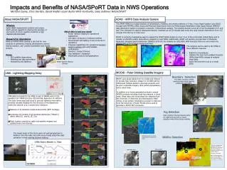
Impact of Satellite OSWV data on NWS Operations. Major Shipping Routes North Pacific 6,000/yr container 1,500/yr bulker. Major Shipping Routes North Atlantic 4,000/yr container transits 1,000/yr bulkers. 195. kts. Hurricane Force Warning Initiated Dec 2000 Detection increased with:

E N D
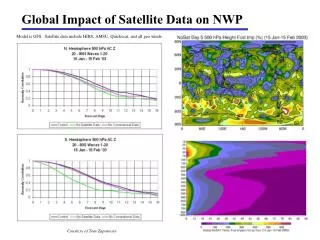
Impact of Satellite OSWV data on NWS Operations Major Shipping Routes North Pacific 6,000/yr container 1,500/yr bulker Major Shipping Routes North Atlantic 4,000/yr container transits 1,000/yr bulkers 195 kts • Hurricane Force Warning Initiated Dec 2000 • Detection increased with: • Forecaster familiarity • Data availability • Improved resolution • Improved algorithm 168 Improved wind algorithm and rain flag Oct 06 WARNING CATEGORIES Pre- QSCAT 1. GALE 34-47 kt 2. STORM >48 QSCAT ERA 1. GALE 34-47 kt 2. STORM 48 -63 kt 3. HURCN FORCE > 64 kt OPC Surface Analysis 2005 10 Jan1200 UTC NCEP GFS Model – SLP, Winds 2005 10 Jan 0900UTC – 3 hr FCST 12.5 km QuikSCAT available May 04 25 km QuikSCAT Available in N-AWIPS Oct 01 988hPa Timelines Timelines Hurricane Force Wind Warning Initiated Dec 00 Totals A-289 P-269 558 38 988hPa QuikSCAT Launch Jun 99 .WARNINGS. ...HURRICANE FORCE WIND WARNING... .LOW 43N161W 962 MB MOVING NE 25 KT. WITHIN 240 NM S AND SW AND 150 NM E AND NE QUADRANTS WINDS 50 TO 70 KT. SEAS 23 TO 35 FT...HIGHEST S OF LOW. ELSEWHERE WITHIN 180 NM OF LOW EXCEPT 300 NM S QUADRANT AND ALSO WITHIN 120 NM NE OF A FRONT FROM 44N160W TO 42N155W TO 40N153W WINDS 45 TO 60 KT. SEAS 15 TO 27 FT 15 2 4 (ASCAT-QuikSCAT) Mean error: 0.02 m/s RMS error: 1.25 m/s (ASCAT-QuikSCAT) Mean error: -0.01 m/s RMS error: 1.35 m/s 7 yr average number of extratropical cyclones observed (contoured) with hurricane force winds for the years 2001 - 2008 7 yr average number of extratropical cyclones observed (contoured) with hurricane force winds for the years 2001 - 2008 11 different cyclones were occurring in the Pacific ocean at the same time QuikSCAT identified HF (>64kts) winds on Dec 13th, this storm struck Seattle on Dec 15th Dec 2006 Pacific NW Storm • Maritime extratropical cyclones exist year round. • Sep through May these storms can generate hurricane force winds, waves up to 100ft, and are a significant threat to ocean and coastal commerce. • When they impact land they produce: • strong winds • high surf • significant coastal flooding • snow, rain, and blizzard conditions • power outages HURCN FORCE STORM GALE LOW Khalil A. Ahmad1 , Zorana Jelenak2 , Paul Chang3 (GOVERNMENT PRINCIPAL INVESTIGATOR) , and Joseph Sienkiewicz4 1Dell-Perot Systems at NESDIS/StAR, 2UCAR at NESDIS/StAR, 3NESDIS/StAR, 4NWS/NCEP/OPC • Requirement: • Weather & Water: • Increase lead-time and accuracy for weather and water warnings and forecasts • Improve predictability of the onset, duration, and impact of hazardous and severe weather and water events • Increase development, application, and transition of advanced science and technology to operations and services • Integrate local, regional, and global observation systems into NOAA’s weather and water services to increase the collaboration between NOAA and external environmental partners • Reduce uncertainty associated with weather and water forecasts and assessments • Enhance environmental literacy and improve understanding, value, and use of weather and water information and services • Marine Transportation: • Support decisions in aviation, marine, and surface navigation • Research, develop, and deploy more accurate and timely information products • Science: • How can near real time (NRT) high quality Satellite Ocean Surface Vector Wind (OSVW) data support and improve NWS • wind warning and forecasting products? • Benefit: • National Weather Service forecasters and their customers: • Emergency planners • General public (recipients of weather warnings) • International users • Marine commerce Utility of Satellite OSWV in Detection of Extratropical (ETC) HF cyclones Satellite OSWV Data Availability in NAWIPS Number of detected HF ETC QuikSCAT (2001 – 2009) Operational ASCAT (2007 – present) ASCAT OSWV Data Improvements Geographic Distribution of ETC HF cyclones Operational ASCAT New ASCAT NOAA / NWS Areas of Responsibility QuikSCAT Number of HF ObservationsOct’07 ~ May’08 Last QuikSCAT HF pass from 11/23/09 at 0547 UTC Satellite OSWV Data as Diagnostic tool High Seas Warning Categories GALE – 34-47 knots Force 8/9 STORM – 48-63 knots Force 10/11 HURRICANE FORCE - >64 knots Force 12 Tropical Cylone Warning Categories TROPICAL STORM – 34-63 knots Force 8-11 HURRICANE - >64 knots Force 12 80-90% reduction in detection of hurricane force winds due to loss of QuikSCAT data at Ocean Prediction Center QuikSCAT Use of Satellite OSWV in NWS Operations UW PBL Model – SLP 2005 10 Jan 0752UTC A Critical Data Source Supporting Marine Weather Forecasting and Warning OSWV Data in Extra-tropics OSWV Data in Tropics • Initiate, continue and terminate marine warnings • Marine wind and wave forecasts • Properly identify features such as lows, highs, fronts and areas of convergence • Real-time verification of numerical weather model guidance which improves wind and wave forecasts Used as justification to initiate advisories on TD Four-E (later TS Douglas) and set initial intensity • Science Challenges: • Full utilization of OSWV data in NWS operations. • Novel techniques for improving resolution of ASCAT C-band scatterometer measurements. • Next Steps: • Continue evaluation of OSWV impacts on NWS operations and work on transitioning OSVW measurements from foreign • scatterometer missions into operations • Transition Path: • Experimental version of new STAR ASCAT product will be evaluated by users and disseminated to AWIPS and NAWIPS if • approved ZCZC MIATCDEP4 ALL TTAA00 KNHC DDHHMM TROPICAL DEPRESSION FOUR-E DISCUSSION NUMBER 1 NWS TPC/NATIONAL HURRICANE CENTER MIAMI FL EP042008 800 PM PDT TUE JUL 01 2008 ASCAT DATA AT AROUND 16Z SHOWED THAT THE LOW PRESSURE AREA SOUTHWEST OF MANZANILLO MEXICO HAD A BROAD CENTER ELONGATED NORTH-NORTHWEST TO SOUTH-SOUTHEAST. SINCE THAT TIME...SATELLITE IMAGERY INDICATES THAT THE CIRCULATION AND ASSOCIATED SHOWER ACTIVITY HAS SOMEWHAT CONSOLIDATED AT THE SOUTHERN END OF THE ELONGATION. BASED ON THIS...ADVISORIES ARE INITIATED ON TROPICAL DEPRESSION FOUR-E. THE INITIAL INTENSITY IS 30 KT IN AGREEMENT WITH SATELLITE INTENSITY ESTIMATES FROM TAFB AND SAB...AS WELL AS THE OBSERVED WINDS IN THE EARLIER ASCAT DATA. ... THE ASCAT DATA SHOWED 25-30 KT WINDS IN A BAND THAT IS CURRENTLY ABOUT 200 N MI FROM THE CENTER IN THE NORTHEASTERN QUADRANT. WHILE THE CENTER OF THE CYCLONE IS EXPECTED TO REMAIN WELL OFFSHORE... This is an example of HURRICANE FORCE extratropical cyclone observed by ASCAT in the North Atlantic ocean. The OPC forecaster placed a HURRICANE warning label on the 1200 UTC surface analysis based on the ASCAT pass.