Download
1 / 4
50 likes | 201 Views
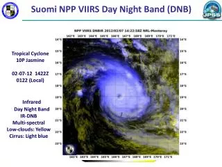
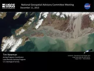
National Geospatial Advisory Committee Meeting December 11, 2013. Tim Newman Acting Program Coordinator Land Remote Sensing Program U.S. Geological Survey. Landsat 8 – Operational Land Imager (OLI) image taken May 28, 2013 of the Copper River – Gulf of Alaska. Suomi NPP VIIRS

E N D
National Geospatial Advisory Committee Meeting December 11, 2013 Tim Newman Acting Program Coordinator Land Remote Sensing Program U.S. Geological Survey Landsat 8 – Operational Land Imager (OLI) image taken May 28, 2013 of the Copper River – Gulf of Alaska Suomi NPP VIIRS Visible Composite
Operational Status • Landsat 8 • USGS assumed operational responsibility from NASA on May 30, 2013 • Collecting well more than 500 new scenes per day • Restored 8-day revisit cycle lost when Landsat 5 was decommissioned • Improvements: better signal-to-noise, new bands (coastal blue, cirrus, thermal) • Better resolution of snow and ice-covered regions • Detection of water column constituents • Better cloud screening • More precise temperature measurements • Landsat 7 • Collecting more than 400 new scenes per day • About 22% of pixels are missing per scene (faulty scan-line corrector) • Sufficient fuel for a few more years of operation; limited subsystem redundancy • Landsat-based Information Products • Standard orthorectified L1T calibrated radiance Landsat scenes • LandsatLook (full-resolution JPEGs browse/print images) • New TM/ETM+ surface reflectance Climate Data Record (CDR) product • New OLI surface temperature CDR in development • Surface Water Extent, Burned Area Extent ECVs available soon for evaluation • Snow-covered area Essential Climate Variable (ECV) late next year
Future Mission Development • NASA and USGS are charged with the task of defining a strategy to extend Landsat’s legacy of over 41 years of data collection • Nearly 5 million scenes in archive; 1000 new scenes acquired daily • 20-year view for continuous data collection • Solution to be flexible enough to ensure continuity with the past, data access in the present, and extensibility to meet the needs of tomorrow • NASA/USGS Sustainable Architecture Study Team is up and running; currently looking at approximately 80 initial concepts • NASA and USGS hosted a Sustainable Land Imaging Architecture Study Industry and Partner Day on September 18, 2013 • Numerous responses received to a follow-up request for information • USGS and NASA hosted a Sustainable Land Imaging Users Forum on December 4, 2013 • One element of a comprehensive USGS requirements collection and analysis project