Download
1 / 1
10 likes | 145 Views
VALIDATION OF SUOMI NPP/VIIRS OPERATIONAL AEROSOL PRODUCTS THROUGH MULTI-SENSOR INTERCOMPARISONS

E N D
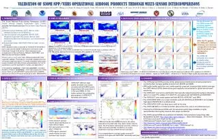
VALIDATION OF SUOMI NPP/VIIRS OPERATIONAL AEROSOL PRODUCTS THROUGH MULTI-SENSOR INTERCOMPARISONS Huang , J. (jingfeng.huang@noaa.gov), I. Laszlo, S. Kondragunta, H. Liu, H-C. Huang, L.A. Remer, H. Zhang, P. Ciren, H. Cronk, J.M. Jackson, N. C. Hsu, B. N. Holben, A. M. Sayer, M. Oo, R. E. Holz, E. J. Hyer, L. A. Munchak, R. Levy, S. Mattoo, M. Petrenko, C.M. Ichoku, R. Kahn, A. Smirnov 1. INTRODUCTION 2. VIIRS vs. Aqua MODIS 3. Multi-Sensor (VIIRS, Aqua MODIS, Terra MODIS, MISR) vs. AERONET (Aerosol Robotic Network) • The Suomi National Polar-orbiting Partnership (S-NPP) Visible Infrared Imaging Radiometer Suite (VIIRS) provides the following aerosol Environment Data Records (EDRs): • Aerosol optical thickness (AOT) (6km at nadir, released as Beta from 05/02/2012) • Aerosol particle size parameter (APSP) EDR (Angstrom Exponent (AE) herein, 6km at nadir, released as Beta from 05/02/2012, not recommended over land) • Suspended matter (SM) EDR (750m at nadir, not yet released) • EDR validations were conducted for 05/02/2012-03/24/2013 over ocean and 01/23/2013-03/24/2013 over land (noted otherwise) through multi-sensor intercomparisons and comparisons to Aerosol Robotic Network (AERONET) and Maritime Aerosol Network (MAN). • A Beta quality product is an “early release product with initial calibration applied. The product is minimally validated and may still contain significant errors. It is made available to allow users to gain familiarity with data formats and parameters, but not for quantitative scientific publications, studies and applications.” The performance of the VIIRS ocean AOT retrievals against AERONET at coastal sites is similar to the heritage satellite products (Aqua and Terra MODIS, Terra MISR). VIIRS 2012 JJA VIIRS 2012 SON VIIRS 2012 DJF OCEAN AOT: VIIRS Mean Bias = 0.011 OCEAN AOT : Aqua MODIS Mean Bias = 0.006 OCEAN AOT: Terra MODIS Mean Bias = 0.010 OCEAN AOT: Terra MISR Mean Bias = 0.038 After the PC update, the VIIRS AOT (550nm) retrievals over land are comparable to heritage satellite products, as compared to AERONET. MODIS 2012 JJA MODIS 2012 SON MODIS 2012 DJF Above: Compared to Aqua MODIS, VIIRS has comparable performances in observing global AOT distribution in the seasonal means. Below: Comparison of the VIIRS and MODIS two-month AOT and AE means (gridded, 0.25°) for Feb-Mar, 2013, after the Processing Coefficient (PC) update on 01/22/2013. LAND AOT: Aqua MODIS Mean Bias = -0.014 LAND AOT: Terra MODIS Mean Bias = -0.043 LAND AOT: Terra MISR Mean Bias = -0.009 LAND AOT: VIIRS Mean Bias = -0.013 The VIIRS AE retrievals over ocean at coastal sites compares well to AERONET similar to the heritage satellite products. VIIRS AOT – MODIS AOT VIIRS AOT MODIS AOT OCEAN AE: Aqua MODIS Mean Bias = -0.128 OCEAN AE: Terra MODIS Mean Bias = -0.230 OCEAN AE: Terra MISR Mean Bias = 0.153 OCEAN AE: VIIRS Mean Bias = 0.254 In the statistics: accuracy = mean bias, precision = standard deviation of biases, uncertainty = root mean square error. Multi-sensor match-up with AERONET were performed by MAPSS (Multi-sensor Aerosol Products Sampling System, NASA/GSFC). Data being used: VIIRS – 01/23/2013-03/24/2013 for Land because of the Processing Coefficient (PC) update on 01/22/2013, 05/02/2012-03/24/2013 for Ocean; MODIS – Same as VIIRS; MISR – 05/02/2012-11/30/2012. Best quality assured data only. VIIRS AE – MODIS AE VIIRS AE MODIS AE 4. VIIRS vs. AERONET (Global View) 5. VIIRS vs. MAN (Maritime Aerosol Network) 7. VIIRS AOT & AE Intermediate Products (IP) 8. SUMMARY • The VIIRS Aerosol EDRs provide similar global aerosol distributions showing potential for continuing their heritage satellite products from MODIS and MISR. • With better spatial resolution over a wide spectral range and increased daily spatial coverage, the VIIRS Aerosol EDRs demonstrate great capability and potential for global aerosol event monitoring. • The VIIRS AOT over land is significantly improved after adjusting spectral surface reflectance ratios in a recent PC update on 01/22/2013, and agrees well with MODIS and AERONET. • The VIIRS AOT over ocean agrees well with MODIS, AERONET, and MAN. • The VIIRS APSP EDR over ocean correlates well with MODIS and AERONET, but is biased high against MODIS AE in a global sense. • The VIIRS APSP EDR over land has no skill at this time. • The VIIRS SM EDR is of limited scientific value at this time, and is not at Beta level yet. • Filtering the VIIRS Aerosol EDRs with the extensive quality flags available is highly recommended. Best quality assured data usage is preferred. • The VIIRS aerosol EDRs are available form NOAA's Comprehensive Large Array-data Stewardship System (http://www.class.ngdc.noaa.gov). (Note: Data between 10/15-11/27 2012 have errors and should not be used.) • VIIRS Aerosol Products Users’ guide is available at: • http://www.star.nesdis.noaa.gov/jpss/ATBD.php#S126472 • VIIRS Aerosol Products README file is under “VIIRS Aerosol” at: • http://www.nsof.class.noaa.gov/saa/products/welcome • Other documents are available at: http://npp.gsfc.nasa.gov/science/documents.html VIIRS AOT (550nm) best quality retrievals over ocean correlate well with MAN cruise observations with mean bias of 0.006 and RMSE of 0.09, further evident the outstanding performance of VIIRS AOT retrievals over ocean. For AOT retrievals over land, there are significant regional differences in the biases between VIIRS and AERONET: high bias over Northern US, but low bias over India and Southeast Asia. There is no significant regional dependence of the bias for AOT ocean retrievals over coastal sites. 6. VIIRS Suspended Matter (SM) EDR • VIIRS SM EDR product reports global distributions of major aerosol types • Ash was tuned out in VCM after 11/02/2012. • VIIRS reports dominant smoke fraction but less dominant dust fraction. VIIRS AOT & AE Intermediate Products (IP) will be released to the public after they reach certain maturity level. The IP products feature pixel resolution (750m at nadir) and are potentially valuable for air quality observations during extreme aerosol outbreaks. It is recommended to use best quality assured IP products that agree with AERONET reasonably well (see above). Although land AE retrievals have no skills, there are regional differences between VIIRS and AERONET: i.e. low biases over western India, eastern US and Mediterranean Sea, but high biases over Amazon, East Asia and some continental areas over Europe. ACKNOWLEGEMENT: Supports from S-NPP and JPSS Programs, and MODIS, MISR, AERONET, MAN, MAPSS teams are greatly appreciated.