Fisheries Triennial Survey Design Evolution for Sustainable Resource Management
40 likes | 139 Views
This study examines the evolution of triennial survey designs from 1983 to 2004 for yellowtail, sablefish, hake, and other species. Data collection methods, vessel charters, strata delineation, trackline spacing, and station allocation strategies are compared across the different survey periods.

Fisheries Triennial Survey Design Evolution for Sustainable Resource Management
E N D
Presentation Transcript
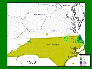
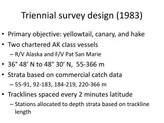
Triennial survey design (1983) • Primary objective: yellowtail, canary, and hake • Two chartered AK class vessels • R/V Alaska and F/V Pat San Marie • 36° 48′ N to 48° 30′ N, 55-366 m • Strata based on commercial catch data • 55-91, 92-183, 184-219, 220-366 m • Tracklines spaced every 2 minutes latitude • Stations allocated to depth strata based on trackline length
Triennial survey design (1989) • Primary objective: juvenile sablefish and hake • Previous rockfish variances too high • Two chartered AK class vessels • F/V Pat San Marie and F/V Golden Fleece • 34° 30′ N to 49° 30′ N?, 55-366 m • High density latitude strata • Strata based on commercial catch data • 55-183, and 184-366 m • Tracklines spaced every 18.5 minutes latitude • High density strata had additional tracklines between in the 55-183m depth strata • 1 station/7.4km in shallow strata • 1 station/9.3km in mid and deep strata
Triennial survey design (1995-2001) • Primary objective: sablefish, hake, slope rockfish • “modified design… periodically to collect more detailed information on specific species groups” • Two chartered AK class vessels • F/V Vesteraalen, R/V Alaska • 34° 30′ N to 49° 30′ N, 55-500m • Stratified by depth • 55-183, 184-366, 367-500 m • 119 tracklines spaced every 10 minutes latitude • 1 station/7.4km in shallow strata • 1 station/9.3km in mid and deep strata
Triennial survey design (2004) • Conducted by the NWFSC • Attempted to follow same protocol as previous surveys