Download
1 / 1
10 likes | 93 Views
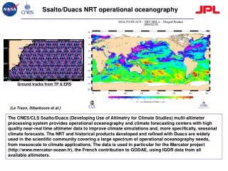
The CNES/CLS Ssalto/Duacs system offers high-quality near-real-time altimeter data to boost climate simulations and seasonal forecasts for operational oceanography needs. Widely used in various applications from mesoscale to climate studies. The processing system is integral for the Mercator project and GODAE.

E N D
Ssalto/Duacs NRT operational oceanography Ground tracks from TP & ERS (Le Traon, Dibarboure et al.) The CNES/CLS Ssalto/Duacs (Developing Use of Altimetry for Climate Studies) multi-altimeter processing system provides operational oceanography and climate forecasting centers with high quality near-real time altimeter data to improve climate simulations and, more specifically, seasonal climate forecasts. The NRT and historical products developed and refined with Duacs are widely used in the scientific community covering a large spectrum of operational oceanography needs, from mesoscale to climate applications. The data is used in particular for the Mercator project (http://www.mercator-ocean.fr), the French contribution to GODAE, using IGDR data from all available altimeters.