Download
1 / 17
170 likes | 284 Views
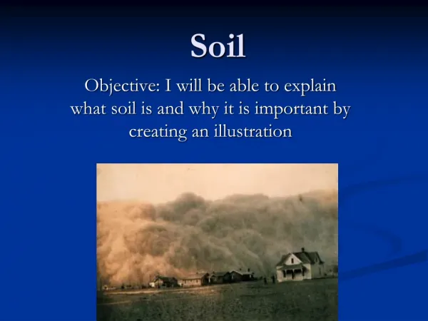
The need for soil information and DSFM activities: the EEA perspective. Anna Rita Gentile, Franz Daffner, Jaume Fons European Environment Agency European Topic Centre on Terrestrial Environment Digital Soil Mapping working group meeting Miskolc, 7-8 April 2005. Background.

E N D
The need for soil information and DSFM activities: the EEA perspective Anna Rita Gentile, Franz Daffner, Jaume Fons European Environment Agency European Topic Centre on Terrestrial Environment Digital Soil Mapping working group meeting Miskolc, 7-8 April 2005
Background • Emerging soil protection policies need timely and reliable soil information. • Inadequate infrastructure for soil information delivery: • No reporting obligations on soil • Information owned by different institutions • Possibility to improve the situation • Better justification of requirements at European level • Stronger coordination/integration of existing networks (ESBN, EIONET) • Better specification in FP7 programme
Existing networks • EIONET • Nominated by countries • Capacity building in member states • Focus on reporting obligations (moral) • Cover a broad range of environmental issues • ESBN • Network of centres of excellence • Providers of soil data & know-how • No own resources
A step further • Steering the process towards a European Soil Information System • Combine capacities • Define an action plan containing • Objectives: information requirements • Definition of targets • Implementation: steps to Digital Soil Functional Map • Road map to targets
Why soil information is needed? • Soil is a basis for human activities • Ensuring sustainable production of biomass • Spatial planning (e.g. Management of contaminated sites) • Transboundary issues • Tools for modeling and outlook (if...) • But, local component important
Statistical information Soil monitoring (sensu stricto) Soil survey (basic information) • Environmental data • Land cover • Topography • Link to other media Impact • Soil media • Status Related information • Drivers • Pressures • Responses Soil Information System
Information required for... • Covering as much as possible the eight threats • Answering relevant policy questions already addressed by the Commission • Making use of existing reporting obligations derived from other policies • Identification of hot spots • Being prepared for new issues
Monitoring and information specifications • Linked to policy-relevant indicators and related data needs • Integrated with existing European monitoring and reporting activities (other media) • Tiered system • country • risk areas/regions of special interest • site-specific • Step-by-step implementation and harmonisation • Guidelines for national monitoring
Soil information • Basic soil information. Soil survey should provide the baseline • Available resource • Characterisation of soils • Assessment of time related soil information (changes) • Evaluation of more dynamic properties • Element contents variation • OM • Nutrients • Heavy metals, pesticides,…
Digital Soil Functional Map • Advantages • Interpreted data • Easy integration • Quality improvement (methodology) • Easy accessibility and transfer of information • Challenges • Too much expectations • Quality data source • Scaling problems: integration of different data sources
Components of the Soil Information System • Basic soil properties • Soil type • Physico-chemical properties • Texture, bulk density, depth • Hydrological properties. Water permeability • pH, base saturaion, OM • Problem areas for different threats • Vulnerability • Risk • Hot spots
Components of the Soil Information System (continued) • Soil functions/properties affected by different threats • Yield function (potential for agricultural production) • Buffering and filtration (pollutants, nutrients) • Regulatory function for water balance • Habitat, Rareness
Example: soil sealing (urbanisation) Loss of soil resources by urbanisation • Type of soils Soil survey • Extension? • Where? • Does it have an impact on agriculture? Intensification,… • Other functions (OM, filtration) Land cover DSFM
Work plan for 2005 • Action plan for soil information (EEA) • Rationale • Basic reference data sets • Information Services • Output. Report covering: • Information requirement specifications • Action plan for monitoring (technical options, organisational settings for monitoring) • Potential connections to other sectors • Input to DSM working group
Where we are • Definition of EEA vision • Link to other EEA projects: • Neighborhood • Indicators • European Spatial Data Infrastructure • PRA.MS • New national expert at EEA
Next steps • Digital Soil Mapping working group meeting. April • Outline of the report. Agreement on contents & contribution. May • Annotated index • Contributions • Schedule • Final report. November.
Further work • Concept for DSFM • Consolidation of the methodology for DSFM • Integration with related data: link to indicators • Improving information exchange • Test at pilot areas, different scales