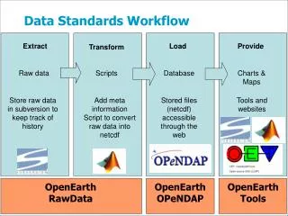
Download

1 / 32
320 likes | 360 Views
This project aims to establish a common set of data standards applicable to trails managed by multiple agencies. It involves developing standardized GPS data dictionaries, databases, and core data standards for efficiently managing trail information. The initiative addresses the importance of standardized terminology, existing data attributes, and implementation feasibility, emphasizing the significance of accurate, shared data across different trail management entities. The Interagency Trail Data Standards (ITDS) provide data attributes, definitions, list of values, parameters, application protocols, and translation crosswalks to ensure consistent and accessible trail information. Collaboration among various agencies is key in implementing and adapting the ITDS to enhance trail management and accessibility. ###

E N D
InteragencyTrail Data Standards USDA Forest Service ▪ Bureau of Land Management National Park Service ▪US Fish and Wildlife Service
Getting It… Together Development of the “ITDS” • Requested by Interagency Trails Council • Establish a common set of data standards • Applicable to all agency-managed trails
Data Dictionary or Database? Interagency Task: • Develop standardized GPS Data Dictionary? • Develop standardized database? • Develop a core set of common data standards?
Data Dictionary or Database? Interagency Task: • Develop standardized GPS Data Dictionary? • Develop standardized database? • Develop a core set of common data standards?
Data Dictionary or Database? Interagency Task: • Develop standardized GPS Data Dictionary? • Develop standardized database? • Develop a core set of common data standards?
Data Dictionary or Database? Interagency Task: • Develop standardized GPS Data Dictionary? • Develop standardized database? • Develop a core set of common data standards ….that can be incorporated into data dictionaries or databases
Trail… What’s a Trail? Interagency Trail Definition: A linear route managed for human-powered, stock, or OHV forms of transportation or for historic or heritage values.
Factors to Consider • Interagency core data set • Data aren’t cheap! • Standardized terminology • Existing, standardized data attributes • Implementation feasibility & timeframes
ITDS Attribute Review Criteria Does (or is) the Attribute… • Relate to a core interagency question? • Of national, regional or statewide significance? • Provide data needed to meet applicable laws, regulations and/or policies? • Address key congressional, OMB and department-wide reporting requirements? • Currently available or obtainable?
What Do We Want To Know? Interagency Trail Questions • Basic Trail Information (trail name, length, location, etc.) • Management Information (trail uses, accessibility status, condition, cost, etc.) • Additional NST / NHT Questions (trail administrator, certified sites and segments, etc.)
Answering the Questions Interagency Trail Data Standards • Data Attribute • Attribute Definition • List of Values (LOVs) • Data Parameters • ITDS Application Protocols • Crosswalk Translation (if needed)
Is the Trail Accessible?Data Standard Example Data Attribute:Accessibility Status Attribute Definition:Accessibility guideline compliance status for the trail or trail segment. List of Values:Accessible Not Accessible Not Evaluated
ITDS Codes Standardized List of Values for each Attribute
ITDS Data Parameters Defined for Each ITDS Attribute • GIS Item Name • GIS Alternate Name • Data Definition (Type & Width) • Attribute Null / Not Null • Multiple Values Allowed?
ITDS Attributes 34 3 13
Interagency BenefitsAdditional Benefits of Working Together Interagency Trail Tools • Trail Class • Managed Use • Designed Use • NHT Corridor Concept • NHT Condition Categories
Currently Underway Interagency Trail and GIS representatives currently collaborating on: Federal Trail Data StandardsPublication of the ITDS by the Federal Geographic Data Committee (FY07-FY08)
Upcoming Tasks? • National Scenic Trail Attributes Identify additionally needed NST attributes • Apply ITDS to Long-Distance Trails Provide implementation guidance, suggestions and examples for NST’s and NHT’s • ITDS Implementation Strategy/Schedule For USFS, BLM, NPS, and FWS • Additional Trail Information Attributes Potential expansion of ITDS to include additional trail use & visitor Information
ITDS USDA Forest Service ▪ Bureau of Land Management National Park Service ▪US Fish and Wildlife Service
Frequently Asked Questions How are agencies incorporating the Interagency Trail Data Standards? BLM: Adapting the standards into FAMS NPS: Adapting the standards into FMSS FWS: Adapting the standards into SAMMS USFS: Majority of standards incorporated in Infra Trails. Remaining standards planned for Infra Trails or Infra Heritage (for specific NHT attributes)
County B 13.2 County A 24.3 5.6 0.0 Frequently Asked Questions What’s “trail segment” mean? “Trail segment” is used informally to identify the specific portion of trail to which a data attribute refers– or to answer the question being asked…
County B 13.2 County A 24.3 5.6 0.0 Frequently Asked Questions Trail Segment Examples: Trail Length: 24.3 miles(segment 0.0 - 24.3) County:5.6 miles County A; 18.7 miles County B (segment 0.0 – 5.6 and 5.6 – 24.3) Trail Class:13.2 miles Trail Class 3; 11.1 miles Trail Class 2 (segment 0.0 – 13.2 and 13.2 – 24.3)
Frequently Asked Questions What’s “No Overlap Allowed” Mean? No Overlap Allowed: Only one attribute value can be recorded at any given location along the trail or trail segment. Example: County Mile 0.00 – 17.4: Park County Mile 17.4 – 28.3: Grove County
Frequently Asked Questions What’s “No Overlap Allowed” Mean? No Overlap Allowed: Only one attribute value can be recorded at any given location along the trail or trail segment. Example: County Mile 0.00 – 17.4: Park County Mile 17.4 – 28.3: Grove County Overlap Allowed: More than one attribute value can be recorded, if applicable, at any given location along the trail or trail segment. Example: Prohibited Use Mile 0.00 – 28.3: ATVs, Motorcycles, Bicycles
Frequently Asked Questions What about “things along the trail”? • “Things along the trail” include trail structures, amenities, viewpoints, etc. • While potentially valuable data at the trail or agency-specific level, this level of detail was determined to be beyond the scope of the interagencystandards.
Frequently Asked Questions For additional questions, answers and clarification: • Appendix G: Interagency Internal Review • Appendix H: Frequently Asked Questions Posted at www.nps.gov/gis/trails/index.html
Bottom-Line Benefits Interagency Trail Data Standards • Improved communication and efficiency • For our internal and external customers • Through proactive interagency trails coordination and collaboration
ITDS USDA Forest Service ▪ Bureau of Land Management National Park Service ▪US Fish and Wildlife Service