Download

1 / 16
160 likes | 181 Views
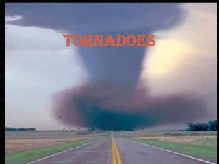
Learn about tornado dynamics, forecasting, and the genesis of tornadoes including the Enhanced Fujita scale and mesocyclone-induced tornadoes.

E N D
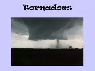
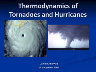
Tornadoes – forecasting, dynamics and genesis Mteor 417 – Iowa State University – Week 12 Bill Gallus
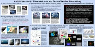
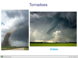
Tools to diagnose severe weather risks • Definition of tornado: A vortex (rapidly rotating column of air) associated with moist convection that is intense enough to do damage at the ground. • Note: Funnel cloud is merely a cloud formed by the drop of pressure inside the vortex. It is not needed for a tornado, but usually is present in all but fairly dry areas.
Intensity Scale: Enhanced Fujita scale since 2007: • EF0 Weak 65-85 mph (broken tree branches) • EF1 Weak 86-110 mph (trees snapped, windows broken) • EF2 Strong 111-135 mph (uprooted trees, weak structures destroyed) • EF3 Strong 136-165 mph (walls stripped off buildings) • EF4 Violent 166-200 mph (frame homes destroyed) • EF5 Violent > 200 mph (steel reinforced buildings have major damage)
Supercell vs QLCS • It has been estimated that 60% of tornadoes come from supercells, with 40% from QLCS systems (may be more in IA). • Instead of treating these differently, we will concentrate on mesocyclonic versus non-mesocyclonic tornadoes • Supercells almost always produce tornadoes from mesocyclones. For QLCS events, it is harder to say what is happening –they may end up with mesocyclones playing a role, but usually these are much shorter lived.
Tornadoes - Mesocyclone-induced a) Usually occur within rotating supercells b) vertical wind shear leads to horizontal vorticity which is tilted by the updraft to produce storm rotation, which is stretched by the updraft into a mesocyclone with scales of a few kms to 10s of kms. c) updrafts, though, explain only mid-level rotation. Low-level rotation seems to require downdrafts, and there are 2 thunderstorm downdrafts to pay attention to: I) FFD (forward-flank-downdraft) marks the edge of rain-cooled air and creates baroclinically-generated horizontal vorticity which can either be stretched by updraft into stronger spin, or slowly sink in downdraft tilting vorticity and advecting it down to help create strong low-level rotation. II) RFD (rear-flank-downdraft) is usually dry and descends from behind the storm (south or southwest side) and appears to play a very MAJOR role in getting tornadoes
d) RFD may have several causes: I) precipitation-loading II) precipitation causes evaporation and negative buoyancy III) stagnation high pressure aloft forces air downward IV) low pressure in area of rapid rotation causes air to descend e) RFD descent can lead to area of anticyclonic rotation on outer edge of hook. Vortex lines in idealized rotating storm show that RFD will increase rotation as it descends, possibly creating strong mesocyclone or tornado cyclone (identified as TVS in radar – tornado vortex signature) f) RFD impacting ground can lead to very strong convergence beneath main rotation area, which could greatly stretch vorticity to create tornado g) Also, rear-to-front flow relative to downdraft will cause vortex rings created by downdraft to tilt and be pulled into updraft, yielding strong low-level rotation h) Anew updraft can form out ahead of the old one if the RFD surges and occludes the older mesocyclone, cutting off inflow to it. This can lead to tornado families, or cyclic tornadoes, or apparent skipping of the tornado.
h) It is also possible the tornado forms as a Descending Reflectivity Core (DRC), or “blob” descends from the storm top in the neighborhood of the hook echo. This can happen just from rain falling (and not evaporative cooling) and would also tilt horizontal vortex lines to enhance cyclonic rotation in one area and create anticyclonic rotation in another. i) Tornado touch-down often happens around the time that storm tops begin to lower and storm seems to weaken. j) Tornado usually happens at the tail end of the hook echo. The hook itself may be created when precipitation is caught in the mesocyclone and swept around the circulation. But, some evidence suggests it descends in place within the hook, almost as though the storm “overflows” with precipitation at the top, and some falls around the updraft where ascent is too strong to allow precipitation to fall. k) as tornado matures, precipitation can wrap around it, hiding it. This is especially true in HP storms. l) some evidence that temperature of the RFD is very important in getting tornado. If too cold, no tornado. Warm RFDs favor strong, long-lived tornadoes.
In summary, mid-level rotation organizes a storm so that it can generate low-level rotation (i.e. Tornado)
2. ) Non-mesocyclone-induced (e.g., landspout) a) can occur within multicell or single cell storms when a low-level zone of vorticity exists (colliding outflow boundaries, eddies along boundaries, fronts) b) low-level vorticity is stretched by intense upward motion and thus a tornado is built from the bottom up. c) the origin is similar to a waterspout, and thus they are sometimes called landspouts d) These systems can still get strong, up to EF3, but stronger tornadoes require mesocyclones e) can be very difficult to locate on Doppler radar
3) Hybrid cases a) some storms have a rather weak mid-level circulation but produce intense tornadoes b) many storms with strong mid-level rotation fail to produce tornadoes. Significant tornadoes may require some pre-existing low-level source of vorticity c) Some landspout tornadoes develop rotation in a deep enough column to take on some mesocyclone characteristics.
QLCS tornadoes • Latest theories suggest QLCS tornadoes may not differ too much in their cause from supercells – as sinking air in main rain region helps create vortex rings that are tilted by rear-to-front flow through them, pulling them into updraft. Strong cyclonic rotation can develop on north side of strong updrafts.
Forecasting Previously, people looked for high CAPE, high 0-3km Storm Relative Helicity (SRH), and EHI > 1-2 Now, other parameters are favored more. In general you want a warm RFD and lots of low-level stretching. Thus, LCL height < 800 m is needed for significant tornado (low LCLs are good) MLLCL < 1000-1200 m for tornadoes 0-1 km RH > 65% (dew point depressions at surface of 10-11 F or less) LFC height < 1303 m for F2 or stronger, average for any tornado is 1499 m, for supercells without tornadoes, it is around 1890 m 0-1 km EHI (median for sig tornadoes is 2.1, for weak it is 1.4) 0-1 km SRH (165 average for sig tornadoes, 137 for weak) 0-3 km CAPE (F2-F5 tornadoes usually have around 100 J/kg or more) MLCIN < 50 J/kg for tornadoes Vorticity Generation Potential (VGP = shear*CAPE**0.5) should > .27 for sig tornadoes 0-1 km bulk shear > 15-20 knots for good tornadoes
In general, you want: (1) “moist” low-levels (high RH, low LCL) (2) good stretching potential down low (0-3 km CAPE, 0-1 km EHI, LFC, CIN) (3) good low-level shear (0-1 km SRH, 0-3 km VGP) Different rules tend to apply for tropical system tornadoes or for cold core low tornadoes Jon Davies has shown for big cold 500 mb lows, 0-3 km CAPE and low-level vorticity can be most important parameters. Temps and dew points are often in the 50s or 60s with mainly cloudy, cool conditions when these happen.