Download

1 / 128
1.28k likes | 1.31k Views
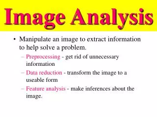
Explore XGOHI data analysis, including imagery examples, brightness temperature differences, wind detection, fire characterization, and the benefits of remapping GOES-10 data. Conclusions and future work highlighted.

E N D
XGOHIImage and Select Product Analysis T. Schmit, NOAA/NESDIS ASPB C. Schmidt, CIMSS G. S. Wade , NOAA/NESDIS ASPB T. Schreiner, CIMSS D. Stettner, CIMSS D. Santek, SSEC and the SSEC Data Center Madison, WI 9-October-2007
Outline • Introduction • 25-June-2007 analysis • Using SSEC archive for non-remapped (‘control’) data • Imagery examples • Image differences • Histograms • Products: • CSBT (Clear-Sky Brightness Temperature) • Winds • Fires • 02-Oct-2007 • Conclusions/Future work • Back-up slides • Approximately 80 slides
Introduction • Due to a large (and increasing) satellite inclination, a remap (before) GVAR distribution for GOES-10 Imager data are being considered. • Remapped GOES-10 GVAR data from 25-June-2007 and via the satellite re-broadcast (12-July-2007, 23-July-2007) were investigated. • Problems with the navigation of the “control” (org.) data were found on the user side, most likely due to NOAA ELUG legacy code still being used for the IMC OFF test condition. • Acquired “control” data through direct ingest at SSEC which had high BER noise without a tracking antenna for the relatively high inclination of GOES-10. • Experience with remapped 4um MET-8 data from EUMETSAT (and the nature of fire pixels) focused our analysis on the fire detection and characterization.
Why XGOHI? GOES-9 High Inclination Movie (Inclination of approximately 1.8 degrees)
“Direct Ingest” or “org.” -- Nav off, also some noise due to ingest
GOES-10 (Remapped), no ingest noise due to ftp’ed datasets Good navigation. Actually June 25th data.
GOES-10 Visible band (Remapped) Actually June 25th data.
Visible Some of the differences are caused by differing navigation, along with one dataset has noisy values due to ingest.
Visible Some of the differences are caused by differing navigation, along with one dataset has noisy values due to ingest.
IR Window Some of the differences are caused by differing navigation, along with one dataset has noisy values due to ingest.
IR Window Some of the differences are caused by differing navigation, along with one dataset has noisy values due to ingest.
Mean Stats (N=4,860,000) In general, the mean values are very similar.
Clear-Sky Brightness Temperature GOES-10 (Org.) Shortwave Window
GOES-10 (Remapped) Clear-Sky Brightness Temperature GOES-10 (Remapped) Shortwave Window
Clear-Sky Brightness Temperature GOES-12 Shortwave Window
Archive vs Remapped winds • Remapped data successfully ran through the Atmospheric Motion Vector (AMV) (aka “winds”) codes. • Given the differences in the image datasets (noise, nav offsets, registration errors in the non-remapped data), the derived wind sets are ‘quite close’.
Fire Detection (0 to -20 latitude ) G-10 origG-10 remapG-12Processed 182 116 143 Low poss 147 90 72 All 379 227 236 • Subset was used to eliminate a bad line of data in the unremapped dataset. • Note that the unremapped data has additional noise due to local satellite ingest. • GOES-12 has a hotter saturation temperature, along with a different view angle.
Fires • Only one time period was extensively investigated. • As expected, fire detection results are different between the remapped and non-remapped datasets, although they are generally similar. • GOES-10 remapped apparently have less fires detected that the remapped data, but a similar overall value compared to GOES-12. • Suggest further study to quantify differences, especially with a dataset that only has any differences being the remapping. • Fire applications should not stop the implementation of the XGOHI operations.
GOES-10 Fires CPTEC, Brazil Courtesy of web page of Dr. Alberto Setzer http://www.cptec.inpe.br/satelite/metsat/queimada/GeoSat/Old/Qda/Goes10/2007/10/
Apparent earth ‘wobble’ is removed prior to distribution. Good navigation with XGOHI data. Each user does not need to remap GOES-10 Imager data. Done once, with the same method. Remap data latency increase is not huge (~3 minutes). In general, the fire signature is retained. Meteorological product information retained. Helps prepare uses for future remapped imager data (eg, the ABI) Detector number/line information is lost. (Most users/applications do not use this information.) Process is not reversible Users still need to remap GOES-10 Sounder data. (Fewer users of direct GOES Sounder radiances) Increased data latency (~ 3 minutes). Fire detection is changed (slightly degraded) from original data. (No ‘truth’ for comparisons.) Pro’s and Con’s of XGOHI
Conclusions • SSEC Data was able to read the remapped GVAR data both via ftp and the downlink. • Image comparison are favorable. Good navigation/registration of the remapped “XGOHI” data. • Several imager products were produced from the XGOHI remapped data. Results were not identical, but similar. • Compared to GOES-12, meteorological products are similar. • Care must be taken to monitor the fire products. • Given the current remapping parameters, the pro’s of XGOHI (steady image loops) outweigh the con’s (slightly changed hot spot detection) for this extended life operations. • Given that the details of the remap matter, thanks to many for making these re-mapped data available before operational implementation and considering the need of hot spot detection.
Possible Future work • Broadcast more sample “XGOHI” data. • Look at more/difference cases, especially with the other variables constant. • Have additional uses investigate other datasets/time periods, especially for fire applications. • Leverage XGOHI remapping experience to prepare for the (remapped) ABI data on GOES-R.
Outline • Introduction • 22-November-2006 • Navigation way off (100 km to a continent) • 25-June-2007 • Using SSEC archive for non-remapped data, nav error ~10km • Imagery • Histograms • Products: • CSBT Winds Fires • 12-July-2007 • Imagery • 23-July-2007 • Imagery • Conclusions
Terrible Nav – can’t used this “control” (non-remapped) dataset