Download
1 / 102
1.02k likes | 1.04k Views
Learn about California fault lines, earthquake history, and impacts. Topics include San Andreas Fault, historical earthquakes, seismic activity, and geological structures. Discover key events like the 1906 San Francisco earthquake.

E N D
Faulting - Normal faults • Sierra Nevada fault is the most important example in California • March 27, 1872 Owens valley earthquake • 8.5 M - California’s greatest • 29 killed • Cities on normal faults – Bishop, Reno, Carson City
Types of faults - Thrust faults • The southern boundary of the transverse range is a series of east trending thrust faults • Santa Monica fault system • Sierra Madre fault system • The 1994 Northridge earthquake was an example • These faults may be characterized by very high horizontal acceleration
Types of faults - Thrust faults • Thrust faults may be buried beneath parts of the Los Angeles basin and not visible on the surface • Cities on or very near thrust faults • Pasadena • all foothill communities
Types of faults - Strike slip faults • These faults dominate the geology of California • Active for 30 m.y. • 10's to 100's of miles of displacement • These are the most active faults in California • 6 out of 10 earthquakes occur on these faults
Types of faults - Strike slip faults • Right lateral faults are most common • They dominate the peninsular range and coast range • They trend NW-SE • Mostly active
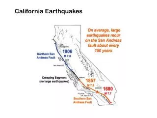
Types of faults - Strike slip faults • San Andreas-San Jacinto faults are most important • Right lateral • 600 miles in length • 300+ miles of displacement • Fault makes a major bend through the transverse range
Types of faults - Strike slip faults • San Andreas-San Jacinto faults are most important • Studies by Caltech indicate 9 major San Andreas earthquakes since the 6th century • Past events ~ 575, 665, 860, 965, 1190, 1245, 1470, 1745, 1857 • Average repeat interval of 160 years
Types of faults - Strike slip faults • San Andreas-San Jacinto faults are most important • 2 major historic earthquakes • (1) 1857 Fort Tejon - 8 M • (2) 1906 San Francisco - 8.3 M
Diagram of southern California showing the San Andreas Fault as a master player in a tectonic setting that includes other faults and compressional fold belts
Types of faults – Strike slip faults • Offshore geology • Important because of proximity to large population centers • Geology is mostly right-lateral strike-slip faults • Cities on strike slip faults – San Bernardino, San Francisco
The April 18, 1906 San Francisco earthquake • Geology of the 1906 earthquake • Magnitude of 8.3 is estimated • Earthquake produced 50 seconds of extreme shaking • The epicenter was 27 miles north of San Francisco • But the damage extended far south and east • Santa Rosa on deep, soft alluvium had worse damage than San Francisco even though it is 19 miles from the San Andreas
The April 18, 1906 San Francisco earthquake Isoseismal map for the San Francisco, California, earthquake of April 18, 1906. Isoseismals are based on MM intensity estimates from data. http://neic.usgs.gov/neis/eq_depot/usa/1906_04_18_iso.html
The April 18, 1906 San Francisco earthquake • A surface rupture 270 miles long extended north and south of San Francisco • Surface offsets of 20 feet • Right-lateral displacement
The April 18, 1906 San Francisco earthquake • The damage to man-made structures • Unreinforced brick and combination brick-frame buildings collapsed Mission Dolores on Dolores at 16th street, and the wrecked Parish church next to it. From the Archives of The Museum of the City of San Francisco
The April 18, 1906 San Francisco earthquake • The damage to man-made structures • The great fire • Water mains were broken to complicate an already inadequate system • 500 blocks burned – 28,000 buildings • Fire burned for 3 days and 3 nights Crowds gather at Market and Laguna streets to flee the Great Fire. Building at lower center right still survives as do along Laguna. Almost all others pictured here burned. From the Archives of The Museum of the City of San Francisco
The April 18, 1906 San Francisco earthquake • The death count in San Francisco • The official 1906 city death count - only 260 people • The official San Francisco government policy of 1906 was to deny the importance of the earthquake • 1987 review by the San Francisco city archivist
The April 18, 1906 San Francisco earthquake • Excellent book on the 1906 earthquake - “The San Francisco earthquake” by Thomas Gordon • Also visit: Museum of the City of San Francisco - 1906 Earthquake and Fire • 16 Views of the Great Earthquake and Fire (in PowerPoint)
The Loma Prieta earthquake • Geological setting of the October 17, 1989 earthquake • The San Andreas and Hayward faults • Right-lateral strike slip faults
The Loma Prieta earthquake • Geological setting of the October 17, 1989 earthquake • The San Andreas and Hayward faults • The part of the fault that ruptured on October 17th is a southern portion of the 280-mile long 1906 break • This area was said to have had a 30 to 60% probability of a M 6-7 earthquake in the next 20 years
The threat of earthquakes extends across the entire San Francisco Bay region, and a major quake is likely before 2030. Knowing this will help people make informed decisions as they continue to prepare for future quakes.
http://geopubs.wr.usgs.gov/fact-sheet/fs151-99/ The Loma Prieta earthquake • Some basics of the October 17th earthquake • Magnitude of 7.1 • Epicenter was 10 miles north of Santa Cruz • Mercalli intensity depended greatly on the firmness of the earth • Rupture area is a southern portion of the 280-mile long 1906 break
The Loma Prieta earthquake Isoseismal map for the Santa Cruz Mountains (Loma Prieta), California, earthquake of October 18, 1989.
The Loma Prieta earthquake • Some basics of the October 17th earthquake • Maximum horizontal acceleration was 0.45 - 0.55 g's near the epicenter • The San Andreas Fault broke along a 25-mile segment in the Santa Cruz Mountains • Focus 11 miles deep • Earth shifted in a right lateral direction 6.5 feet horizontally and 4.5 feet vertical up on the southwest side
The Loma Prieta earthquake • Types of geological damage • Types of geological damage • No surface rupture (all subsurface) • Lurch cracks • Landsliding • Liquefaction
The Loma Prieta earthquake • Types of geological damage • Lurch cracks • Abundant in an area about 3 miles wide near the epicenter • Regional stress • Weak, unconsolidated tertiary sedimentary rocks not being able to respond elastically to severe shaking • Cracks damaged pavement, sidewalks, buildings etc.
The Loma Prieta earthquake • Types of geological damage • Landsliding • Many landslides occurred in the mountains south of S.F. • They are almost entirely on south facing slopes • Many are old landslides that were reactivated • Some roads were closed
The Loma Prieta earthquake • Types of geological damage • Soil liquefaction • Liquefaction is caused by increased pore water pressure • This is an especially severe problem around the San Francisco bay • Large parts of the bay have either: • Soft, water-saturated natural sediment deposited by rivers • Soft sandy man-made fills partly from the 1906 earthquake
The Loma Prieta earthquake • Types of geological damage • The marina of San Francisco • Located 50 miles from the epicenter and still had a IX intensity • A lagoon was filled with 1906 debris to form today's Marina district • Damage included fires, collapsed buildings, broken utilities
An automobile lies crushed under the third story of this apartment building in the Marina District. The ground levels are no longer visible because of structural failure and sinking due to liquefaction. [J.K. Nakata, U.S. Geological Survey]
Smoldering remains of the apartment complex at the corner of Beach and Divisadero Streets, Marina District. [J.K. Nakata, U.S. Geological Survey]
The Loma Prieta earthquake • Types of geological damage • East Bay area • Soil liquefaction damaged: • the Oakland port facility • runway at Oakland international airport • and possibly the Nimitz freeway
The part of the Cypress freeway structure in Oakland, California, that stood on soft mud (dashed red line) collapsed in the 1989 Loma Prieta earthquake, killing 42 people. Adjacent parts of the structure (solid red) that were built on firmer ground remained standing. Seismograms (upper right) show that the shaking was especially severe in the soft mud. (Photograph by Lloyd S. Cluff)
Aerial view of collapsed sections of the Cypress viaduct of Interstate Highway 880. [H.G. Wilshire, U.S. Geological Survey]
The Loma Prieta earthquake • Types of geological damage • East Bay area • Comparison with 1906 • Areas that liquefied in 1906 also did so in 1989 • Water mains needed to fight fires that broke in 1906 did so in 1989 • Maps of damage and intensity for 1906 are similar to 1989
If the Loma Prieta (M~7.0) trace looks smaller, it is because the 1906 (M~7.8) earthquake released approximately 16 times more energy:
Sand boil or sand volcano measuring 2 m (6.6 ft) in length erupted in median of Interstate Highway 80 west of the Bay Bridge toll plaza when ground shaking transformed loose water-saturated deposit of subsurface sand into a sand-water slurry (liquefaction). Vented sand contains marine-shell fragments. [J.C. Tinsley, U.S. Geological Survey]
The Loma Prieta earthquake • Human damage • Injuries • 62 deaths • 3,757 injuries • 12,000 homeless • $6 billion in property damage
The Loma Prieta earthquake • Buildings • No building constructed to code collapsed • Buildings on solid ground in the epicentral area did well if they were built to code • Buildings 50 miles away in San Francisco on weak fill did poorly
The Loma Prieta earthquake • Buildings • Older buildings sometimes did poorly because • General deterioration • Not attached to the foundation • Unreinforced masonry, brick or stone • Lack of lateral reinforcement • Pounding by adjacent buildings
The Loma Prieta earthquake • Bridges • The Nimitz freeway (rte 880) - triple-decker built between 1949-1954 • Southbound lanes fell on the Oakland bound lanes killing 41 • Damage has been attributed to inadequate bracing and poor soil • Freeway was pre-1971 and funds for retrofitting for earthquake safety had been withdrawn • One span of the Oakland bay bridge fell • Cause uncertain
Aerial view of the collapsed section of the San Francisco-Oakland Bay Bridge. View westward. [C.E. Meyer, U.S. Geological Survey]
The Loma Prieta earthquake • Predicted and actual events of October 17, 1989 • Predicted are based on a model 6.5 to 7.5 M earthquake on the Hayward fault • The following is a comparison of events predicted by the U.S. geological survey to occur based on a study of the Hayward fault compared to what actually occurred on October 17, 1989.
San Fernando EQ aka Sylmar EQ February 9, 1971, 6:01 am PST MW 6.6 Fort Tejon EQ January 9, 1857, ~8:20 am PST Mw 8.0 Northridge EQ January 17, 1994 4:30:55 am PST MW 6.7 Map of southern California, with epicenters of historic earthquakes (as far back as 1812) of particular note plotted over the background topography. Shown, too, are major highways (in tan) and the surface traces of major faults (in greenish-blue). This map does not show the epicenters of all earthquakes greater than magnitude 4.5 recorded in the southern California area since the 19th century. From: http://www.scecdc.scec.org/clickmap.html
The 1971 San Fernando Earthquake • Facts • Time: February 9, 1971, 6:01 am PST • Magnitude: Mw 6.6; Intensity: XI • Depth: 8.4 km • Length of shaking: 60 seconds! • Type of faulting: thrust • Fault involved: San Fernando Fault Zone; • Minor offset reported on the eastern Santa Susana Fault Zone