Download
1 / 22
220 likes | 457 Views
FEMA Region III Storm Surge Project. Construction of The Digital Elevation Model The Foundation of a Storm Surge Model FEMA Region III Coastal Storm Surge Project Workshop November 1 2011 Michael F. Forte, Lisa Stillwell, Jason F. Miller, Jeffrey L. Hanson. FEMA Region III Domain.

E N D
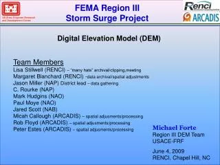
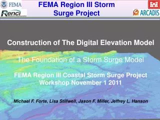
FEMA Region III Storm Surge Project Construction of The Digital Elevation Model The Foundation of a Storm Surge Model FEMA Region III Coastal Storm Surge Project Workshop November 1 2011 Michael F. Forte, Lisa Stillwell, Jason F. Miller, Jeffrey L. Hanson
FEMA Region III Domain 6 States Pennsylvania Delaware Maryland Virginia North Carolina New Jersey Chesapeake and Delaware Bays, Numerous Rivers & Atlantic Seaboard
Data Gathering USACE District offices of Philadelphia, Baltimore, and Norfolk played critical role in obtaining the most accurate up-to-date datasets for Region • Over 125 data sets evaluated (~2 TB) • Data types: • TIFF • CSV • ASCII GRID • Raster • FLT • LAS • Shapefile • SID • and more… • Projections: • NJ, DE, MD, VA State Plane • UTM • Datums: • NAD27 • NAD83 • Tidal (MSL, MLLW, etc.)
Data Sources • US Army Corps of Engineers • USGS • NOAA / NGDC • NC Division of Emergency Management Flood Plain Mapping Program (NCDEM – FMP) • Individual States
Topographic LiDARCoverage 24 LiDARData sets National Elevation Dataset (NED) covered remaining areas
Conversion Horizontal Conversion Geographic Coordinates Decimal Degrees (NAD83) Elevation/depth relative to North American Vertical Datum 1988 (NAVD88) meters
Conversion Vertical Datum Conversion V – Datum (NOAA) Unit Conversion Mean Lower Low water MLLW North American Vertical Datum of 1988 NAVD 88 m
Regional Organization FEMA Region 3 Divided Into 20 Tiles For Efficient Data Management Certain Tiles Contain Up To 6 Gigabytes Of Data.
10m Resolution Interpolation IVS 3-D Fledermaus Interpolation Parameters Weighted Moving Average Algorithm Search weight – average value of 3-5 used Grid Cell Size - 0.00011degrees ~10m cell size Iterative process obtaining best result given data density and Quality Ex. Search Weight
QA/QC Result after interpolation Obvious errors literally “jump out”
USACE Districts DEM Review Cross section from tile 8 reveals anomaly Coordinates are defined for peak and Investigated using Google earth.
USACE Districts DEM Review 8NS5 – Google earth search revealed some square areas that may contain higher elevations (possible mining activities).
ARCADIS DEM Review Tile 3 DEM Reveals Barrier Island not present in Aerial Photograph
Tile 3 Bridge serves as impediment to water flow Bridge Removal
Bridge Removal Tile 3 Delaware River Bridge Impediment Fledermaus conversion to “PFM” and bridge is manually removed
Bridge Removal Tile 3 Re-interpolated with bridge removed
Land Water Interface Lidar Datasets Need Clipping Around land/water interface Profile displays jump of 2.5m
High Quality DEM for Mid-Atlantic • Most Complete up to date seamless DEM available for Mid-Atlantic Region • Comprised of 120 Datasets (~2TB) • Serves a variety of purposes from modeling to sea level rise studies
Documentation /Submittal 1.1 • Documents DEM data, procedures, and USACE District Review • Published as U.S. Army Corps of Engineers ERDC-CHL Technical Report • Available at: • dodreports.com/pdf/ada539477.pdf