Download

1 / 9
90 likes | 232 Views
Title: Total Lightning and Non- Supercell (“ Landspout ”) Tornadogenesis Co-Principle Investigators: Ed Szoke, Dan Bikos & Dr . Steven D. Miller (CIRA/CSU ) Prof . Steven Rutledge ( Department of Atmospheric Science, CSU )

E N D
Title: Total Lightning and Non-Supercell(“Landspout”) Tornadogenesis Co-Principle Investigators: Ed Szoke, Dan Bikos & Dr. Steven D. Miller (CIRA/CSU) Prof. Steven Rutledge (DepartmentofAtmospheric Science, CSU) *keycomponent: Fullfundingof a graduatestudentthrough Steve R Other Participants: Geoffrey Stanos (NASA/SPoRT, Huntsville, Alabama) Dave Barjenbruch, Robert Glancy, Robert Kleyla and Lisa Kriederman (NOAA/NWS/Boulder Weather Forecast Office) Rob Cox and Rebecca Mazur (NOAA/NWS/Cheyenne (Wyoming) Weather Forecast Office) Brian Motta (NOAA/NWS HQ Training Division, Boulder, Colorado) Project Duration: 2 Years (FY15+16) : 1 July 2015 – 30 June 2017
Why is this different from previous/ongoing studies of total lightning and severe weather & tornadoes? • By design we are focusing just on non-supercell tornadoes • WHY? • They present a big warning challenge because the typical radar signals associated with (supercell) tornado development are not present • So one would think forecasters would be interested in anything that might help give them some more lead time • The formation mechanism for the non-supercell tornado is directly linked to the updraft of a developing cell • So there should be a very “clean” link to total lightning • This link is not at all clear-cut for supercell tornado development • There does not seem to be much previous and ongoing research with total lightning and severe weather focusing on this type of tornado....(exceptions that we are aware of: see next slide)
Some previous applicable studies that we are aware of • A new study by Larry Carey (UAH/AB) • Just started: M.S. student working on non-supercell tornadoes and total lightning around the northern AL LMA • This would make a nice compliment to a study out here (High Plains) • Would the/any signals in total lightning be different? • In a recent exchange with Chris Schultz he cited the only nonsupercell tornado that he has looked at that occurred near Huntsville on 3 June 2009 • He noted that the associated cell never produced any lightning since it formed a tornado before the cloud got about the 0o C level • Raises the question of how different our signals might be out here where such an occurrence is unlikely • Goodman et al Central FL study (19th SLS Conference) • Seemed like the nonsupercell cases (3 shown) varied a lot in relation to LJ (next slide) • More recently – Gatlin and Goodman (JAOT 2010): • The nonsupercelltornadic storm shown was quite different from the cases seen here last summer • Noted on page 10: “the Lightning Jump (LJ) should theoretically not provide as much advance notification of tornadogenesis for nonsupercell storms as it would for supercell storms” – opportunity to see if this is really true • Maybe regionally dependent?
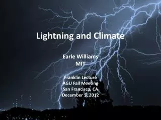
Max reflectivity The Florida cases examined on the left are the only ones we are aware of that examine total lightning and nonsupercell tornadoes (assuming the weak ones are nonsupercells?). A Colorado nonsupercell case (near Erie on 26 Jul 1995) is shown on the right. It is suspected that the DIA storm would exhibit a similar profile. Weak tornado case Weak tornado case T: 2135-2153 From Goodman et al, 19th SLS Conf (1998): FL tornado examples From Brady & Szoke, MWR (1989): CO nonsupercell tornado case Vorticity (x10-2 s-1 Waterspout case
DIA tornado of 18 June 2013 (another nonsupercell tornado occurred near the CYS radar in July) • We think an important first step is to look at both these cases in detail with total lightning as this establishes 2 baseline cases that are very well observed • Add additional cases if available • Then can apply any total lightning criteria to other storms to see if any criteria can be found that would be useful to forecasters • Both with and without a nonsupercell tornado DIA tornado on the airport grounds Tornado track courtesy of forecaster Dave Barjenbruch
CO LMA display 1930-40 UTC CO LMA display 1940-50 UTC CO LMA display 2000-2010 UTC Velocity at 0.3o from TDWR at 2005 UTC